mail_outline sales@mediastorehouse.com
141 items
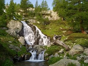
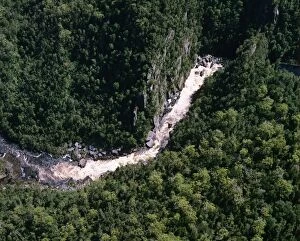
waterfall in Mercantour NP, Casterino, FranceSM-2294 waterfall in Mercantour NP, Casterino, France Stefan Meyers Please note that prints are for personal display purposes only and may not be reproduced in anyway.
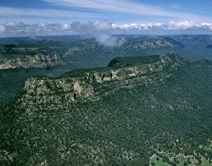
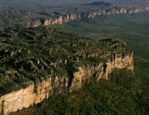
Aerial - Glen Davis area with view south to Blue Mountains National Park - New South Wales, Australia JPF52859JPF-14408 Aerial - Glen Davis area with view south to Blue Mountains National Park New South Wales, Australia Jean-Paul Ferrero Please note that prints are for personal display purposes only
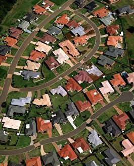
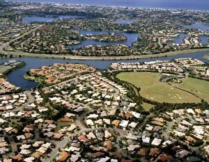
Aerial - Suburban housing development - Port Macquarie, New South Wales, Australia JPF52917JPF-14407 Aerial - Suburban housing development Port Macquarie, New South Wales, Australia Jean-Paul Ferrero Please note that prints are for personal display purposes only
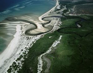
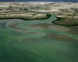
Aerial - Boucaut Bay river mouth, sandy beach & mangroves, Arnhemland (Aboriginal Land), Northern TerritoryJPF-14405 Aerial - Boucaut Bay river mouth, sandy beach & mangroves Arnhemland (Aboriginal Land), Northern Territory, Australia Jean-Paul Ferrero Please note that prints are for personal display
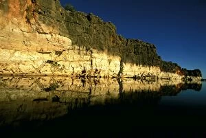
Geikie Gorge - Fitzroy River cuts throughancient limestone cliffs of fossilised reefs - Geikie Gorge National ParkJPF-14403 Geikie Gorge - Fitzroy River cuts throughancient limestone cliffs of fossilised reefs Geikie Gorge National Park, West Kimberley region
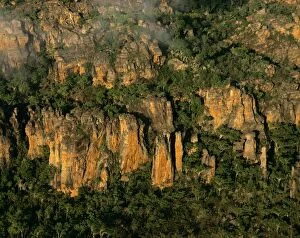
Aerial - Mt Brockman, part of Arnhem Land Escarpment Stone Country: sandstone: kombolgie formation, early ProterozoicJPF-14402 Aerial - Mt Brockman, part of Arnhem Land Escarpment Stone Kakadu National Park (World Heritage Area), Northern Territory, Australia Country: sandstone: kombolgie formation
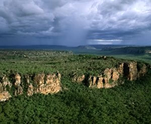
Arnhemland Escarpment with tropical rain storm approaching, wet season (January)JPF-14401 Arnhemland Escarpment with tropical rain storm approaching Kakadu National Park (World Heritage Area), Northern Territory, Australia wet season (January)
Aerial of land rich in iron oxides - the Pilbara seabed rose to form one of Earth's first permanent land massesJPF-14400 Aerial of land rich in iron oxides Hamersley Range, Pilbara region, Western Australia The Pilbara seabed rose to form one of Earths first permanent land masses about 3.5 billion yeras ago
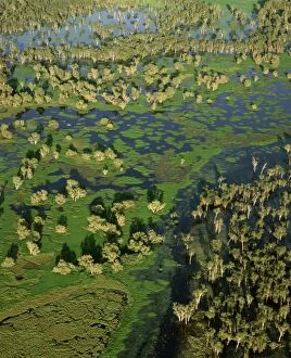
Magela Creek wetlands, Paperbark swamp (Melaleuca spp forest, M. cajuputi, M)JPF-14399 Magela Creek wetlands, Paperbark swamp (Melaleuca spp forest, M.cajuputi, M.leucadendra) aerial Kakadu National Park (World Heritage Area), Northern Territory
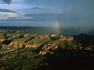
Arnhemland Escarpment - with tropical rain storm approaching and rainbow, wet season (January)JPF-14397 Arnhemland Escarpment - with tropical rain storm approaching and rainbow wet season (January). Sandstone: Kombolgie Formation (early Proterozoic)
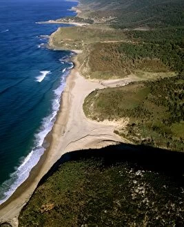
Aerial - Garie Beach, north and south Era beaches with Burning Palms Beach in background, Royal National ParkJPF-14396 Aerial - Garie Beach, north and south Era beaches with Burning Palms Beach in background Royal National Park, New South Wales
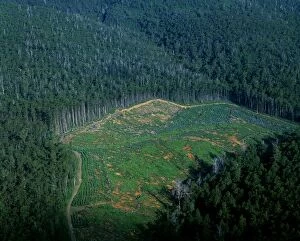
Logging industry: native eucalypt forest cleared for pine plantation loss of biodiversity, Northeastern TasmaniaJPF-14395 Logging industry: native eucalypt forest cleared for pine plantation loss of biodiversity Northeastern Tasmania
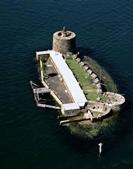
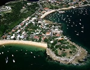
Aerial - Fort Denison Sydney, New South Wales, Australia JPF52647JPF-14394 Aerial - Fort Denison Sydney, New South Wales, Australia Jean-Paul Ferrero Please note that prints are for personal display purposes only and may not be reproduced in anyway.
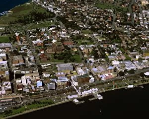
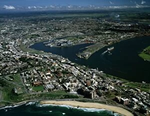
Aerial - City of Newcastle - New South Wales, Australia JPF-14392JPF-14393 Aerial - City of Newcastle - New South Wales, Australia Jean-Paul Ferrero Please note that prints are for personal display purposes only and may not be reproduced in anyway.
Aerial - City of Newcastle - New South Wales, Australia JPF53024JPF-14392 Aerial - City of Newcastle - New South Wales, Australia Jean-Paul Ferrero Please note that prints are for personal display purposes only and may not be reproduced in anyway.
Aerial - Bungle Bungle Range almost vertical shot from the air of sandstone range formed 400 million years agoJPF-14391 Aerial - Bungle Bungle Range almost vertical shot from the air of sandstone range formed 400 million years ago Purnululu National Park
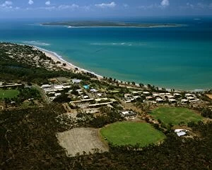
Aerial - Nhulunbuy with Bremer Island in the distance, Gove Peninsula, Northern Territory, Australia JPF55060JPF-14390 Aerial - Nhulunbuy with Bremer Island in the distance Gove Peninsula, Northern Territory, Australia Jean-Paul Ferrero Please note that prints are for personal display purposes only
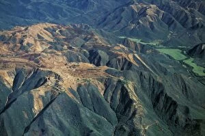
Aerial - Folded mountains near Glen Helen & Finke Gorge West MacDonnell National Park, Northern TerritoryJPF-14389 Aerial - Folded mountains near Glen Helen & Finke Gorge West MacDonnell National Park, Northern Territory, Australia Jean-Paul Ferrero Please note that prints are for personal display
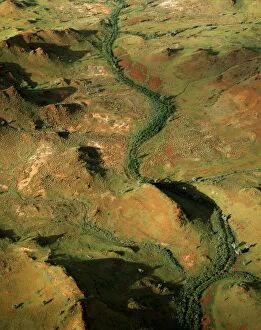
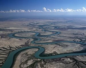
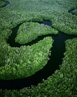
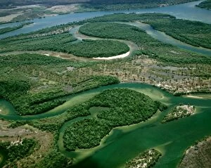
Aerial - Gin Arm Creek, oxbows (meanders) Gulf of Carpentaria, Queensland, Australia JPF48722JPF-14388 Aerial - Gin Arm Creek, oxbows (meanders) Gulf of Carpentaria, Queensland, Australia Jean-Paul Ferrero Please note that prints are for personal display purposes only
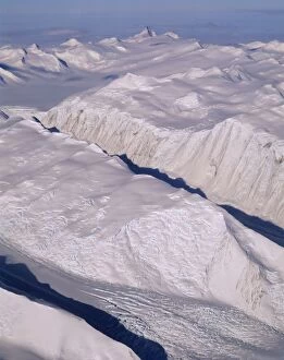
Aerial - Glacier - Admiralty Mountain - Transantarctic Mountains, Antarctica JPF48796JPF-14387 Aerial - Glacier - Admiralty Mountain Transantarctic Mountains, Antarctica Jean-Paul Ferrero Please note that prints are for personal display purposes only
Aerial - Gordon River Franklin - Gordon Wild Rivers National Park, Tasmania, Australia JPF49316JPF-14384 Aerial - Gordon River Franklin Gordon Wild Rivers National Park, Tasmania, Australia Jean-Paul Ferrero Please note that prints are for personal display purposes only
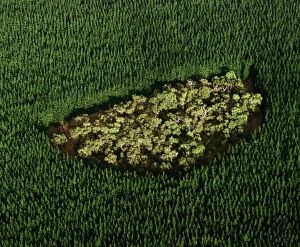
Remnant of native forest in pine plantation - near Mount Gambier, South Australia JPF49482JPF-14382 Remnant of native forest in pine plantation near Mount Gambier, South Australia Jean-Paul Ferrero Please note that prints are for personal display purposes only
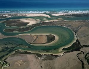
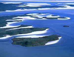
Aerial - Murray River mouth with Hindmarsh Island, Younghusband and Sir Richard Peninsulas South Australia JPF49642JPF-14381 Aerial - Murray River mouth with Hindmarsh Island Younghusband and Sir Richard Peninsulas South Australia Jean-Paul Ferrero Please note that prints are for personal display purposes only
Aerial - Newcastle Bay and Kennedy Inlet - with mangroves - Cape York Peninsula, Queensland, Australia JPF49931JPF-14380 Aerial - Newcastle Bay and Kennedy Inlet - with mangroves Cape York Peninsula, Queensland, Australia Jean-Paul Ferrero Please note that prints are for personal display purposes only
Aerial - Archer River - Gulf of Carpentaria, Cape York Peninsula, Queensland, Australia JPF49961JPF-14379 Aerial - Archer River Gulf of Carpentaria, Cape York Peninsula, Queensland, Australia Jean-Paul Ferrero Please note that prints are for personal display purposes only
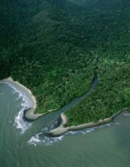
Aerial - Tropical rainforest near Cape Tribulation Daintree National Park, Queensland, Australia JPF50066JPF-14378 Aerial - Tropical rainforest near Cape Tribulation Daintree National Park, Queensland, Australia Jean-Paul Ferrero Please note that prints are for personal display purposes only
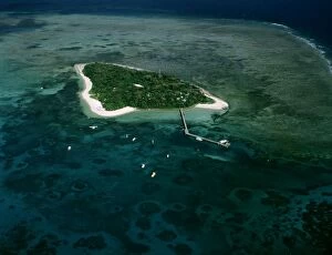
Aerial - Green Island - Green Island National Park, Great Barrier Reef off Cairns, Queensland, Australia JPF50168JPF-14377 Aerial - Green Island Green Island National Park, Great Barrier Reef off Cairns, Queensland, Australia Jean-Paul Ferrero Please note that prints are for personal display purposes only
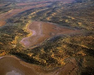
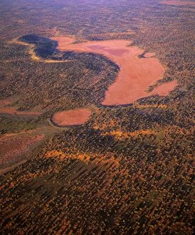
Aerial - Playas / claypans and low dunes the most vegetated and largest sand dune desert in AustraliaJPF-14374 Aerial - Playas / claypans and low dunes the most vegetated and largest sand dune desert in Australia Maralinga-Tjarutja Aboriginal lands - Near Lake Meramangye, Great Victoria Desert
Aerial - Playas/claypans and low dunes the most vegetated and largest sand dune desert in AustraliaJPF-14373 Aerial - Playas/claypans and low dunes the most vegetated and largest sand dune desert in Australia Maralinga-Tjarutja Aboriginal lands - near Lake Meramangye, Great Victoria Desert
Aerial - Arnhem Land Escarpment - Kakadu National Park (World Heritage Area) - Northern Territory, Australia JPF47969JPF-14372 Aerial - Arnhem Land Escarpment Kakadu National Park (World Heritage Area) - Northern Territory, Australia Jean-Paul Ferrero Please note that prints are for personal display purposes only
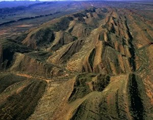
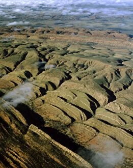
Aerial - James Ranges (Ltalaltuma Aboriginal Land) - Showing geological folds, Northern Territory, Australia JPF47799JPF-14371 Aerial - James Ranges (Ltalaltuma Aboriginal Land) - Showing geological folds Northern Territory, Australia Jean-Paul Ferrero Please note that prints are for personal display purposes only
Aerial - Lake Gairdner - salt lake, South Australia JPF47601JPF-14370 Aerial - Lake Gairdner - salt lake South Australia Jean-Paul Ferrero Please note that prints are for personal display purposes only and may not be reproduced in anyway.
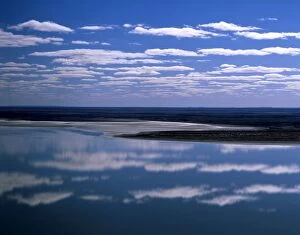
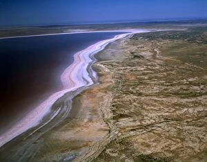
Lake Eyre South, filled Lake Eyre National Park, South Australia JPF48157JPF-14369 Lake Eyre South Lake Eyre National Park, South Australia Jean-Paul Ferrero Please note that prints are for personal display purposes only and may not be reproduced in anyway.
Aerial - McArthur River near delta Gulf of Carpentaria, Northern Territory, Australia JPF48204JPF-14368 Aerial - McArthur River near delta Gulf of Carpentaria Northern Territory, Australia Jean-Paul Ferrero Please note that prints are for personal display purposes only
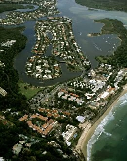
Aerial - Noosa: Heads, main beach & Sound - Sunshine Coast, Queensland, Australia JPF48317JPF-14367 Aerial - Noosa: Heads, main beach & Sound Sunshine Coast, Queensland, Australia Jean-Paul Ferrero Please note that prints are for personal display purposes only
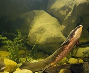
Queensland Lungfish JPF51993JPF-14358 Queensland Lungfish Neoceratodus forsteri Jean-Paul Ferrero Please note that prints are for personal display purposes only and may not be reproduced in anyway.
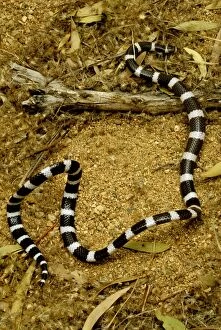
Eastern bandy-bandy - ‘looping in alarm, a nocturnal burrowing snake, Western New South Wales, Australia JPF45686JPF-14353 Eastern bandy-bandy - looping in alarm, a nocturnal burrowing snake Western New South Wales, Australia Vermicella annulata Jean-Paul Ferrero Please note that prints are for personal display
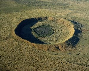
Aerial - Wolfe Creek meteor crater - 25 million years old, Wolfe Creek Crater National Park, Kimberley regionJPF-14352 Aerial - Wolfe Creek meteor crater - 25 million years old Wolfe Creek Crater National Park, Kimberley region, Western Australia Jean-Paul Ferrero Please note that prints are for personal
Aerial - Nickel mines - Thio, east coast, New Caledonia JPF46283JPF-14351 Aerial - Nickel mines - Thio East coast, New Caledonia Jean-Paul Ferrero Please note that prints are for personal display purposes only and may not be reproduced in anyway.
Aerial - Rainbow over Perth, Western Australia JPF46414JPF-14349 Aerial - Rainbow over Perth Western Australia Jean-Paul Ferrero Please note that prints are for personal display purposes only and may not be reproduced in anyway.
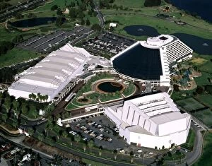
Aerial - Burwood Casino - Perth, Western Australia JPF46403JPF-14348 Aerial - Burwood Casino Perth, Western Australia Jean-Paul Ferrero Please note that prints are for personal display purposes only and may not be reproduced in anyway.
Aerial - Lake Eyre North Dry salt lake that floods a few times each centuryJPF-14347 Aerial - Lake Eyre North Dry salt lake that floods a few times each century Jackboot Bay, along Hunt Peninsula (Elliot Price Conservation Park) Lake Eyre National Park
Aerial - Camp Cove, Laings Point and Watsons Bay - Sydney Harbour, New South Wales, Australia JPF45384JPF-14345 Aerial - Camp Cove, Laings Point and Watsons Bay Sydney Harbour, New South Wales, Australia Jean-Paul Ferrero Please note that prints are for personal display purposes only
Aerial - Robina and Mermaid Waters Gold Coast, Queensland JPF46582JPF-14346 Aerial - Robina and Mermaid Waters Gold Coast, Queensland, Australia Jean-Paul Ferrero Please note that prints are for personal display purposes only and may not be reproduced in anyway
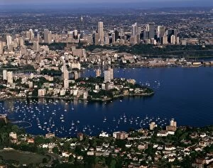
Aerial - Sydney - with Double Bay in foreground Sydney, New South Wales, Australia JPF47089JPF-14343 Aerial - Sydney - with Double Bay in foreground Sydney, New South Wales, Australia Jean-Paul Ferrero Please note that prints are for personal display purposes only
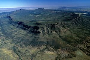
Aerial - Wilpena Pound Flinders Ranges National Park, South Australia JPF42901JPF-14340 Aerial - Wilpena Pound Flinders Ranges National Park, South Australia Jean-Paul Ferrero Please note that prints are for personal display purposes only and may not be reproduced in anyway
Robin - in green bush with snow - UKMAB-1254 Robin - in green bush with snow UK Erithacus rubecula Mark Boulton Please note that prints are for personal display purposes only and may not be reproduced in any way.
Robin - close up in snow UKMAB-1098 Robin - close up in snow UK Erithacus rubecula Mark Boulton Please note that prints are for personal display purposes only and may not be reproduced in any way.