mail_outline sales@mediastorehouse.com
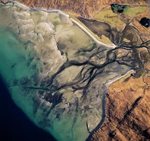
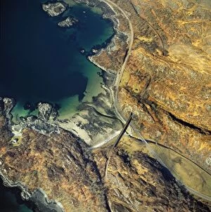
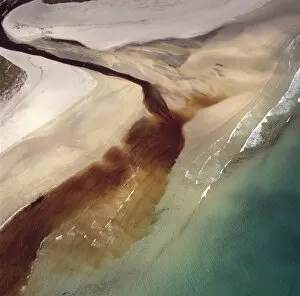
Aerial image of Scotland, UK: Barrisdale Bay, fresh water channels flow out through the sands into the fjord of LochAW-6840 Aerial image of Scotland, UK: Barrisdale Bay fresh water channels flow out through the sands into the fjord of Loch Hourn, the Knoydart Peninsula, near Corran
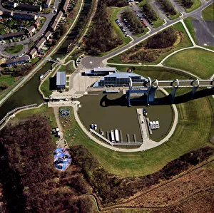
Aerial image of Scotland, UK: The Falkirk Wheel, Falkirk, Scotland, a rotating boat lift connecting the ForthAW-6886 Aerial image of Scotland, UK The Falkirk Wheel, Falkirk, Scotland, a rotating boat lift connecting the Forth and Clyde Canal with the Union Canal
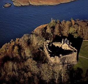
Aerial image of Scotland, UK: Dunstaffnage Castle, a partially ruined 13th century castleAW-6876 Aerial image of Scotland, UK Dunstaffnage Castle, a partially ruined 13th century castle, situated on a platform of conglomerate rock on a promontory at the south-west of the entrance to Loch
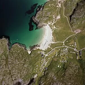
Aerial image of Scotland, UK: Aerial image of Scotland, UK: Ardnambuth beach and peninsula, Lochailort, HighlandAW-6832 Aerial image of Scotland, UK: Aerial image of Scotland, UK: Ardnambuth beach and peninsula Lochailort, Highland, Scotland Adrian Warren contact details: prints@ardea.com tel
Aerial image of Scotland, UK: Achmelvich (Gaelic: Achadh Mhealbhaich), a settlement situated, near Lochinver, HighlandAW-6830 Aerial image of Scotland, UK: Achmelvich (Gaelic: Achadh Mhealbhaich) a settlement situated, near Lochinver, Highland
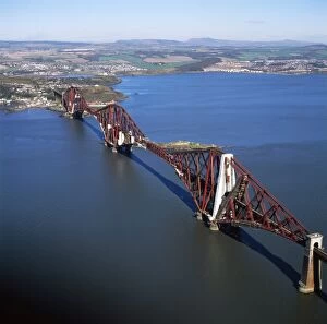
Aerial image of Scotland, UK: The Forth Bridge (Forth Rail Bridge or Forth Railway Bridge), a cantileverAW-6889 Aerial image of Scotland, UK The Forth Bridge (Forth Rail Bridge or Forth Railway Bridge), a cantilever, railway bridge over the Firth of Forth (estuary of firth) in the east of Scotland
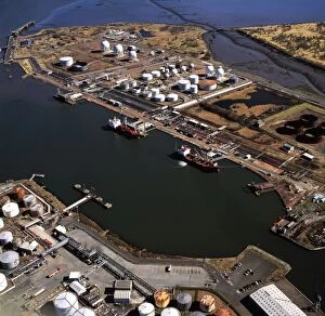
Aerial image of Scotland, UK: Grangemouth Docks and Grangemouth oil refineryAW-6897 Aerial image of Scotland, UK Grangemouth Docks and Grangemouth oil refinery Adrian Warren contact details: prints@ardea.com tel: +44 (0) 20 8318 1401
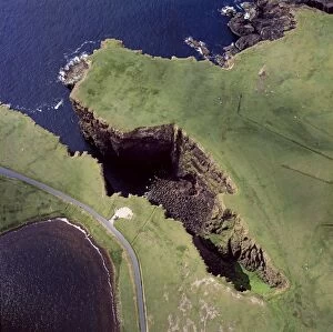
Aerial image of Scotland, UK: Volcanic Cliffs, just North east of Esha Ness (Eshaness), Northmavine peninsulaAW-6883 Aerial image of Scotland, UK Volcanic Cliffs, just North east of Esha Ness (Eshaness), Northmavine peninsula, Shetland Islands
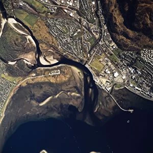
Aerial image of Scotland, UK: Fort William, the largest town in the highlands of ScotlandAW-6888 Aerial image of Scotland, UK Fort William, the largest town in the highlands of Scotland, lies at the southern end of the Great Glen
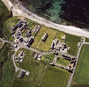
Aerial image of Scotland, UK: Ruined Church, Eynhallow, a small uninhabited island lies in Eynhallow Sound betweenAW-6884 Aerial image of Scotland, UK Ruined Church, Eynhallow, a small uninhabited island lies in Eynhallow Sound between Mainland, Orkney and Rousay, Orkney Islands
Aerial image of Scotland, UK: Glamis Castle, was the childhood home of Elizabeth Bowes-Lyon (the Queen Mother)AW-6892 Aerial image of Scotland, UK Glamis Castle, was the childhood home of Elizabeth Bowes-Lyon (the Queen Mother), village of Glamis, Angus
Aerial image of Scotland, UK: Dunnideer Castle, a 13th century tower houseAW-6874 Aerial image of Scotland, UK Dunnideer Castle, a 13th century tower house, built partially from the remains of an existing vitrified hill fort, Aberdeenshire, Scotland
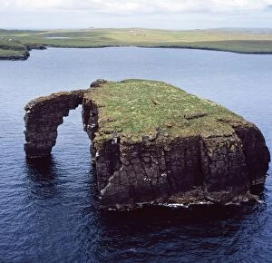
Aerial image of Scotland, UK: Dore Holm, a small islet with a natural arch, off the south coast of Esha NessAW-6880 Aerial image of Scotland, UK Dore Holm, a small islet with a natural arch, off the south coast of Esha Ness, in the west of Mainland
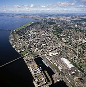
Aerial image of Scotland, UK: Dundee City, the fourth-largest city in ScotlandAW-6873 Aerial image of Scotland, UK Dundee City, the fourth-largest city in Scotland, on the north bank of the River Tay's estuary, Lowlands
Aerial image of Scotland, UK: Dunbar, a town in East Lothian on the southeast coast of ScotlandAW-6870 Aerial image of Scotland, UK Dunbar, a town in East Lothian on the southeast coast of Scotland Adrian Warren contact details: prints@ardea.com tel: +44 (0) 20 8318 1401
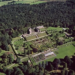
Aerial image of Scotland, UK: Drummond Castle and one of Scotland's finest Italian Renaissance style formalAW-6868 Aerial image of Scotland, UK Drummond Castle and one of Scotland's finest Italian Renaissance style formal gardens, south of Crieff
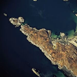
Aerial image of Scotland, UK: Corra-Bheinn, Isle of Mull, Argyll and Bute, Inner HebridesAW-6867 Aerial image of Scotland, UK: Corra-Bheinn, Isle of Mull, Argyll and Bute, Inner Hebrides Adrian Warren contact details: prints@ardea.com tel: +44 (0) 20 8318 1401
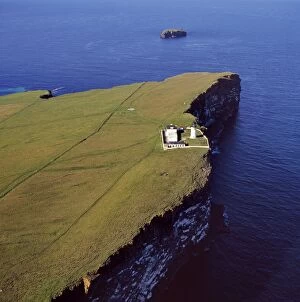
Aerial image of Scotland, UK: Lighthouse at Copinsay, Orkney MainlandAW-6866 Aerial image of Scotland, UK: Lighthouse at Copinsay, Orkney Mainland Adrian Warren contact details: prints@ardea.com tel: +44 (0) 20 8318 1401
Aerial image of Scotland, UK: Dun Carloway, Carloway, on the west coast of the Isle of LewisAW-6861 Aerial image of Scotland, UK: Dun Carloway, Carloway, on the west coast of the Isle of Lewis, Outer Hebrides a remarkably well preserved Iron Age Broch
Aerial image of Scotland, UK: Clickimin broch, Lerwick, Shetland IslandsAW-6864 Aerial image of Scotland, UK: Clickimin broch, Lerwick, Shetland Islands a large and well preserved Iron Age broch in Scotland which contained a later wheelhouse
Aerial image of Scotland, UK: Callanish Standing Stones, Callanais, Isle of Lewis and HarrisAW-6860 Aerial image of Scotland, UK: Callanish Standing Stones, Callanais, Isle of Lewis and Harris, Outer Hebrides a group of stones that date from the late Stone Age and early Bronze Age
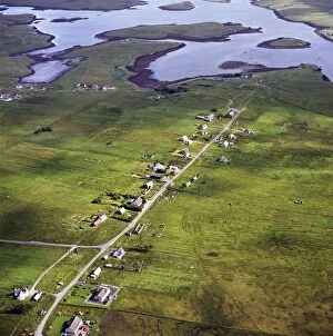
Aerial image of Scotland, UK: Callanish, a village (township), situated on a headland jutting into a sea lochAW-6859 Aerial image of Scotland, UK: Callanish, a village (township), situated on a headland jutting into a sea loch Loch Roag, near Stornoway, West Side of the Isle of Lewis, Outer Hebrides
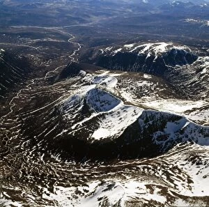
Aerial image of Scotland, UK: Cairn Toul (Hill of the barn) of The Cairngorms, the fourth highest mountain in ScotlandAW-6858 Aerial image of Scotland, UK: Cairn Toul (Hill of the barn) of The Cairngorms the fourth highest mountain in Scotland, surpassed only by Ben Nevis, Ben Macdui and Braeriach
Aerial image of Scotland, UK: Brough of Deerness, Mull Head, Mainland Orkney - Remains of a 10th century chapel in aAW-6855 Aerial image of Scotland, UK: Brough of Deerness, Mull Head, Mainland Orkney Remains of a 10th century chapel in a spectacular headland setting on the eastern tip of Deerness
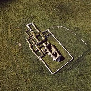
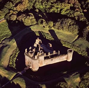
Aerial image of Scotland, UK: Caerlaverock Castle, a 13th-century triangular moated castle in the Caerlaverock NationalAW-6856 Aerial image of Scotland, UK: Caerlaverock Castle a 13th-century triangular moated castle in the Caerlaverock National Nature Reserve area at the Solway Firth, Glencaple
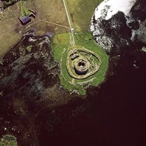
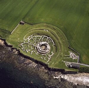
Aerial image of Scotland, UK: The Broch of Gurness, an Iron Age broch with a surrounding settlement on the northwestAW-6854 Aerial image of Scotland, UK: The Broch of Gurness an Iron Age broch with a surrounding settlement on the northwest coast of Mainland Orkney Adrian Warren contact details
Aerial image of Scotland, UK: Earl's Palace, Birsay, a 16th century ruined castleAW-6850 Aerial image of Scotland, UK: Earl's Palace, Birsay, a 16th century ruined castle north west corner of Mainland Orkney Adrian Warren contact details: prints@ardea.com tel
Aerial image of Scotland, UK: Brough of Birsay, a small uninhabited tidal island off the north west coast of MainlandAW-6849 Aerial image of Scotland, UK: Brough of Birsay, a small uninhabited tidal island off the north west coast of Mainland Orkney, north west coast of Orkney Mainland
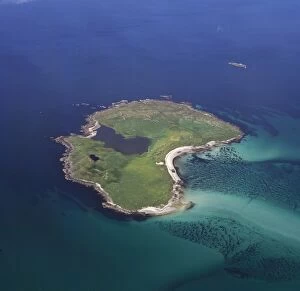
Aerial image of Scotland, UK: Boreray, an island in the Outer Hebrides, lies 2km north of North UistAW-6852 Aerial image of Scotland, UK: Boreray, an island in the Outer Hebrides lies 2km north of North Uist, West Coast Scotland. The island is dominated by Loch Mr ('big loch')
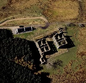
Aerial image of Scotland, UK: Bernera Barracks, Glenelg, HighlandAW-6846 Aerial image of Scotland, UK Bernera Barracks, Glenelg, Highland Adrian Warren contact details: prints@ardea.com tel: +44 (0) 20 8318 1401
Aerial image of Scotland, UK: Castle Law, an Iron Age hill fort, sits above the confluence of the River TayAW-6829 Aerial image of Scotland, UK: Castle Law, an Iron Age hill fort, sits above the confluence of the River Tay and River Earn Abernethy
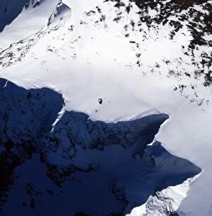
Aerial image of Scotland, UK: Summit of Ben Nevis (Scottish Gaelic: Beinn Nibheis)AW-6845 Aerial image of Scotland, UK: Summit of Ben Nevis (Scottish Gaelic: Beinn Nibheis) the highest mountain in Great Britain
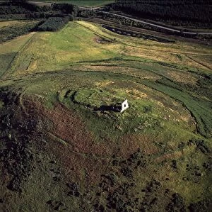
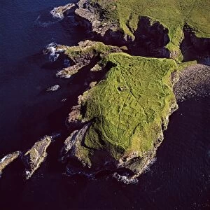
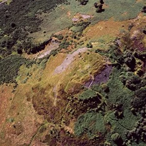
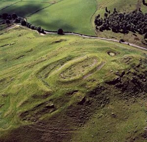
Aerial image of Scotland, UK: Hill of Barra, an Iron Age hill fort withtraces of mediaeval ridgeAW-6839 Aerial image of Scotland, UK: Hill of Barra an Iron Age hill fort with traces of medieval ridge and furrow cultivation
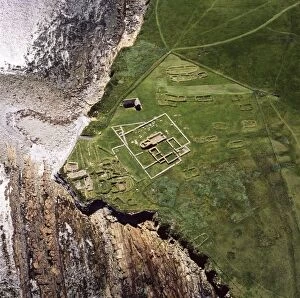
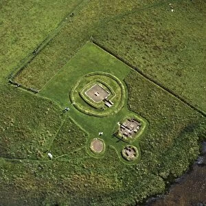
Aerial image of Scotland, UK: The Neolithic Barnhouse Settlement, sited by the shore of Loch of HarrayAW-6838 Aerial image of Scotland, UK: The Neolithic Barnhouse Settlement sited by the shore of Loch of Harray, Orkney Mainland
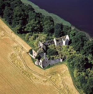
Aerial image of Scotland, UK: Ballinbreich Castle (Chapel Hill, Chapel Of Glenduchie) by the river Tay, FifeAW-6836 Aerial image of Scotland, UK: Ballinbreich Castle (Chapel Hill, Chapel Of Glenduchie) by the river Tay, Fife Adrian Warren contact details: prints@ardea.com tel: +44 (0) 20 8318 1401
Aerial image of Scotland, UK: Ardnambuth beach, Lochailort, Highland, ScotlandAW-6833 Aerial image of Scotland, UK Ardnambuth beach, Lochailort, Highland, Scotland Adrian Warren contact details: prints@ardea.com tel: +44 (0) 20 8318 1401
Aerial image of Scotland, UK: Sinclair's Bay, south of Keiss, north-east Caithness, east coast of ScotlandAW-6851 Aerial image of Scotland, UK: Sinclair's Bay south of Keiss, north-east Caithness, east coast of Scotland. Water of the Burn of Lyth flows through Loch of Wester
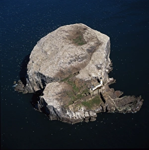
Aerial image of Scotland, UK: Bass Rock (The Bass), Volcanic plug of Phonolite in the Firth of Forth, near AuldhameAW-6841 Aerial image of Scotland, UK: Bass Rock (The Bass) Volcanic plug of Phonolite in the Firth of Forth, near Auldhame, East Lothian