mail_outline sales@mediastorehouse.com
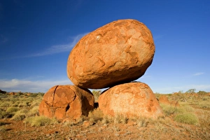
Devils Marbles - a balanced rock of red granite is situated on top of two boulders - Devils Marbles Conservation AreaSAS-1129 Devils Marbles - a balanced rock of red granite is situated on top of two boulders Devils Marbles Conservation Area, Northern Territory, Australia The Devils Marbles
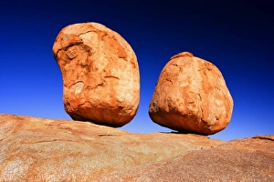
Devils Marbles - two nearly perfectly circular shaped boulder of red granite balanced on bedrock - Devils MarblesSAS-1126 Devils Marbles - two nearly perfectly circular shaped boulder of red granite balanced on bedrock Devils Marbles Conservation Area, Northern Territory, Australia The Devils Marbles
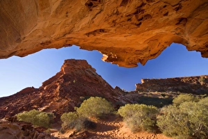
Mushroom Rock view from sandstone rock formation called the mushroom onto the colourful cliffs of Rainbow ValleySAS-1092 Mushroom Rock - view from sandstone rock formation called the mushroom onto the colourful cliffs of Rainbow Valley
Lost City at sunset - ancient sandstone formations carved out by the Finke river millions of years ago - Finke GorgeSAS-1087 Lost City at sunset - ancient sandstone formations carved out by the Finke river millions of years ago Finke Gorge National Park, Northern Territory
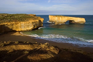
London Bridge - collapsed sandstone arch London Bridge. The force of the sea eats more and more of the rocks awaySAS-1086 London Bridge - collapsed sandstone arch London Bridge. Port Campbell National Park, Great Ocean Road, Victoria, Australia The force of the sea eats more and more of the rocks away
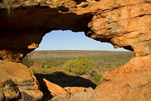
Keep River Rock formations - a window in the red rocks with a view toward the less rockier section of the NationalSAS-1079 Keep River Rock formations - a window in the red rocks with a view toward the less rockier section of the National Park
Thunderstorm over the Bay of Islands - dark clouds are gathering over sandstone rock stacks in the Bay of IslandsSAS-1043 Thunderstorm over the Bay of Islands Bay of Islands Coastal Park, Great Ocean Road, Victoria, Australia dark clouds are gathering over sandstone rock stacks in the Bay of Islands
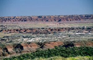
USA - Arizona - Blue Mesa Petrified Forest National Park - Painted Desert showing gully erosionWAT-2304 USA - Arizona - Blue Mesa Petrified Forest National Park Painted Desert showing gully erosion M. Watson Please note that prints are for personal display purposes only
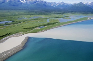
Alaska USA - showing river joining sea Hallo Bay, Katmai, AlaskaWAT-1574 Alaska USA - showing river joining sea Hallo Bay, Katmai, Alaska. M. Watson Please note that prints are for personal display purposes only and may not be reproduced in any way
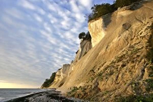
Cliffs of Moen steep chalk cliffs and pebble beach Mons Klint, Moen Peninsula, DenmarkSAS-45 Cliffs of Moen - steep chalk cliffs and pebble beach Mons Klint, Moen Peninsula, Denmark Steffen & Alexandra Sailer Please note that prints are for personal display purposes only
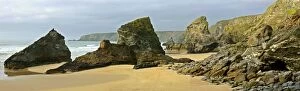
Bedruthan Steps rugged coastline with sea stacks Cornwall, England, UKSAS-133 Bedruthan Steps - rugged coastline with sea stacks Cornwall, England, UK Steffen & Alexandra Sailer Please note that prints are for personal display purposes only
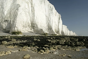
UK - chalk cliffs coastline with white cliffs. Seven Sisters Country Park, East Sussex, England, UKSAS-131 UK - chalk cliffs coastline with white cliffs. Seven Sisters Country Park, East Sussex, England, UK Steffen & Alexandra Sailer Please note that prints are for personal display purposes only
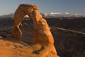
Delicate Arch - probably the best-known natural arch in the USA. Evening light. Arches National Park, UtahROG-12272 Delicate Arch - probably the best-known natural arch in the USA, evening light. Arches National Park, Utah, USA Bob Gibbons Please note that prints are for personal display purposes only
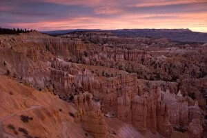
Bryce Canyon: Dawn view from Sunset PointROG-12255 Bryce Canyon National Park - dawn view from Sunset Point Utah, USA Bob Gibbons Please note that prints are for personal display purposes only and may not be reproduced in any way
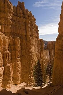
Bryce Canyon: Sandstone cliffs below Sunset PointROG-12252 Bryce Canyon National Park, Sandstone cliffs below Sunset Point. Utah, USA Bob Gibbons Please note that prints are for personal display purposes only and may not be reproduced in any way
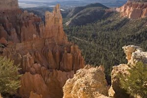
Bryce Canyon, FairviewROG-12249 Bryce Canyon, National Park, Fairview, Utah, USA Bob Gibbons Please note that prints are for personal display purposes only and may not be reproduced in any way
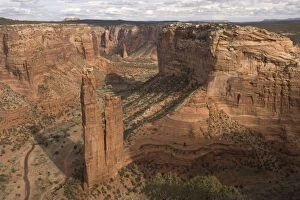
Canyon de Chelly National Monument, on Navajo tribal ground. View over Spider Rock and upper canyonROG-12232 Canyon de Chelly National Monument Navajo tribal ground Bob Gibbons Please note that prints are for personal display purposes only and may not be reproduced in any way
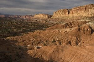
View of the extensive Waterpocket Fold in Capitol Reef National Park - a vast 100-mile long foldROG-12213 View of the extensive Waterpocket Fold Capitol Reef National Park Bob Gibbons Please note that prints are for personal display purposes only and may not be reproduced in any way
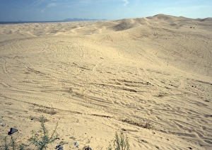
Algodones dunes - huge off-road vehicle recreation area, now devoid of vegetationROG-11859 Algodones dunes - huge off-road vehicle recreation area, now devoid of vegetation. SE California, near Mexican border, USA
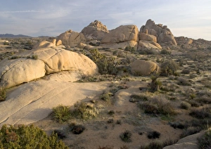
Joshua Tree National Park California, USAROG-11839 Joshua Tree National Park California, USA. Bob Gibbons Please note that prints are for personal display purposes only and may not be reproduced in any way
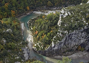
Gorge du Verdon, Provence-Alpes, in autumn. Looking down into gorge from balcons de la MesclaROG-11821 France - Gorge du Verdon, Provence-Alpes, in autumn. Looking down into gorge from balcons de la Mescla Bob Gibbons Please note that prints are for personal display purposes only
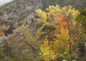
Gorge du Verdon, Provence-Alpes: autumn colour from black poplars, aspens etcROG-11820 Gorge du Verdon, Provence-Alpes: autumn colour from black poplars, aspens etc. France Bob Gibbons Please note that prints are for personal display purposes only
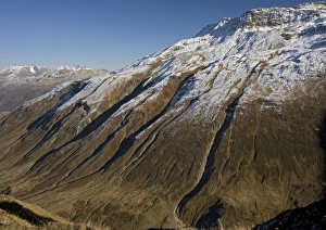
Erosion on mountains just east of the Furka Pass, south Switzerland. After first autumn snowROG-11728 Erosion on mountains just east of the Furka Pass, south Switzerland. After first autumn snow. Bob Gibbons Please note that prints are for personal display purposes only
Dorset World Heritage coast, just west of Lulworth. Chalk cliffsROG-11493 Dorset World Heritage coast, just west of Lulworth. Chalk cliffs. Part of the Jurassic coast, Dorset, UK Bob Gibbons Please note that prints are for personal display purposes only
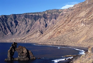
Canary Islands - La Arena beach. Hierro IslandPPG-1660 La Arena beach, Hierro Island, Canary Islands Pascal Goetgheluck Please note that prints are for personal display purposes only and may not be reproduced in any way
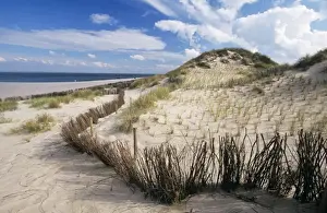
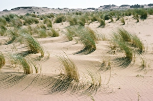
Dune - with dunegras branches for fixing the duneME-399 Dune - with dunegrass branches for fixing the dune Johan De Meester Please note that prints are for personal display purposes only and may not be reproduced in any way
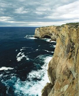
Australia Cliffs in Jervis Bay, New South Wales. Nature reserve of the Capital Territory about 170 km south of SydneyJPF-5428 AUSTRALIA - Cliffs in Jervis Bay Nature Reserve of the Captial Territory about 170Km South of Sydney. New South Wales Jean Paul Ferrero Please note that prints are for personal display
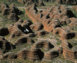
Western Australia Pumululu National Park Bungle Bungle Range. Sandstone range formed 400 million years ago from layeredJPF-12796 Western AUSTRALIA - Sandstone range eroded into Beehive formation and deep canyon valleys. Ecotourism: light plane flying over the range Purnululu National Park
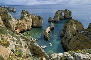
Portugal - cliffs Ponta da Piedade Nr LagosJLMO-1773 Portugal - cliffs Ponta da Piedade Nr Lagos John Mason Please note that prints are for personal display purposes only and may not be reproduced in any way
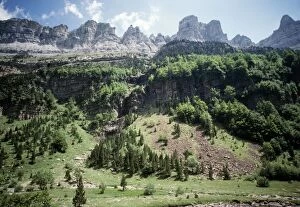
Spain Ordesa Natinal ParkJLMO-1023 SPAIN -Ordesa National Park John Mason Please note that prints are for personal display purposes only and may not be reproduced in any way
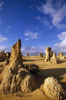
Western Australia - The Pinnacles Desert Nambung National Park, Western AustraliaGET-961 Western AUSTRALIA - The Pinnacles Desert, Nambung National Park Nambung National Park, Western Australia. Geoff Trinder Please note that prints are for personal display purposes only
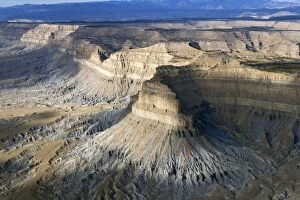
Aerial view of the Book Cliffs - north of the town of Green River, Utah; looking North-EastFG-eb-890 The Book Cliffs are carved into the Mancos Shale (marine deposits, grey talus slope), capped by sandstone of the Mesaverde Group, Upper Cretaceous Utah
Aerial view of the Book Cliffs - looking north, Between Grand Junction, Colorado, and Green RiverFG-eb-889 The Book Cliffs are carved into the Mancos Shale (marine deposits, grey talus slope), capped by sandstone of the Mesaverde Group, Upper Cretaceous Utah
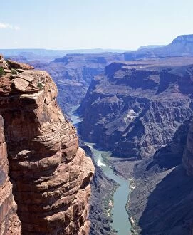
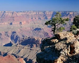
USA Colorado River, Grand Canyon, Arizona, USAFG-6037 Colorado River - running through the Grand Canyon Arizona, USA Francois Gohier Please note that prints are for personal display purposes only and may not be reproduced in any way
Arizona, USA Grand CanyonFG-6035 USA - ARIZONA - GRAND CANYON Francois Gohier Please note that prints are for personal display purposes only and may not be reproduced in any way
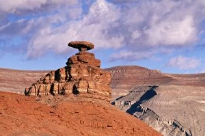
USA Mexican hat, Erosional formation, UtahFG-12246 USA - Utah, Mexican Hat, Erosion Formation Francois Gohier Please note that prints are for personal display purposes only and may not be reproduced in any way
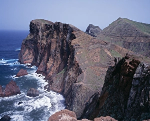
Madeira Ponta De Sao Lourenco (most westerly point)DAD-776 MADEIRA - Ponta De Sao Lourenco, Nature Reserve David C Dixon Please note that prints are for personal display purposes only and may not be reproduced in any way
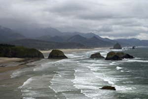
Cannon Beach and Sea Stacks from Ecola State Park North Oregon Coast USA LA000882COS-1508 Cannon Beach and Sea Stacks from Ecola State Park North Oregon Coast, USA Bill Coster Please note that prints are for personal display purposes only and may not be reproduced in any way
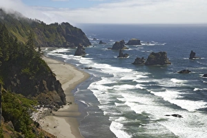
Shoreline between Brookings & Gold Beach showing offshore stacks Oregon Coast, USA LA000847COS-1504 Shoreline between Brookings & Gold Beach showing offshore stacks Oregon Coast, USA Bill Coster Please note that prints are for personal display purposes only
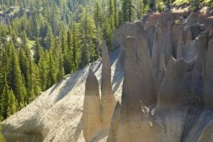
The Pinnacles Crater Lake National Park Oregon, USA LA000700COS-1488 The Pinnacles Crater Lake National Park, Oregon, USA Bill Coster Please note that prints are for personal display purposes only and may not be reproduced in any way
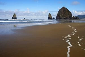
Haystack Rock at low tide Cannon Beach, Oregon, USA LA000948COS-1444 Haystack Rock at low tide Cannon Beach, Oregon, USA Bill Coster Please note that prints are for personal display purposes only and may not be reproduced in any way
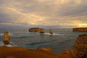
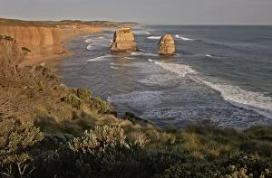
Australia, Victoria - Looking west to the Twelve Apostles Port Campbell National Park September 2005AU-00020-jon Australia, Victoria - Looking west to the Twelve Apostles Port Campbell National Park September 2005 Auscape Please note that prints are for personal display purposes only
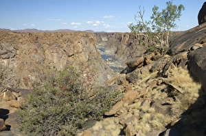
Orange River below Augrabies Falls viewed from Arafat lookout. Karoo Boer-bean tree (Schotia afra)ASW-4284 South Africa - Augrabies Falls National Park, Northern Cape Orange River below Augrabies Falls viewed from Arafat lookout. Karoo Boer-bean tree (Schotia afra) flowering in foreground
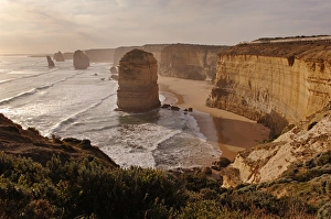
Australia, Victoria - Looking east to the Twelve Apostles Port Campbell National Park September 2005AU-00018-jon Australia, Victoria - Looking east to the Twelve Apostles Port Campbell National Park September 2005 Auscape Please note that prints are for personal display purposes only
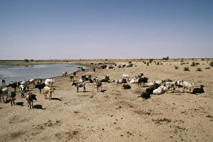
Africa Cattle herd by water, desertification. Sahel region, Burkina FasoBMD-4 BURKINA FASO - Sahel cattle herd Africa Brian McDairmant Please note that prints are for personal display purposes only and may not be reproduced in any way
Marram Grass - & sand dunes CorfuSG-7008 Marram Grass - & sand dunes Corfu Ardea London Please note that prints are for personal display purposes only and may not be reproduced in any way
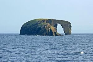
Rock Arch Dore Holm, Shetland's most famous rock arch Northmavine, North Mainland, Shetland Isles, Scotland, UKSAS-522 Rock Arch - Dore Holm, Shetland's most famous rock arch Northmavine, North Mainland, Shetland Isles, Scotland