mail_outline sales@mediastorehouse.com
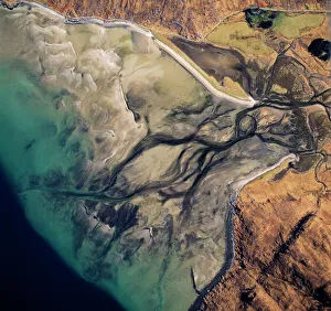
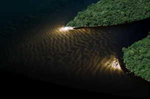
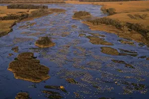
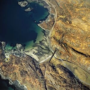
Aerial image of Scotland, UK: Barrisdale Bay, fresh water channels flow out through the sands into the fjord of LochAW-6840 Aerial image of Scotland, UK: Barrisdale Bay fresh water channels flow out through the sands into the fjord of Loch Hourn, the Knoydart Peninsula, near Corran
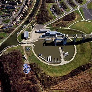
Aerial image of Scotland, UK: The Falkirk Wheel, Falkirk, Scotland, a rotating boat lift connecting the ForthAW-6886 Aerial image of Scotland, UK The Falkirk Wheel, Falkirk, Scotland, a rotating boat lift connecting the Forth and Clyde Canal with the Union Canal
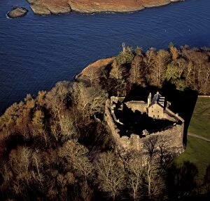
Aerial image of Scotland, UK: Dunstaffnage Castle, a partially ruined 13th century castleAW-6876 Aerial image of Scotland, UK Dunstaffnage Castle, a partially ruined 13th century castle, situated on a platform of conglomerate rock on a promontory at the south-west of the entrance to Loch
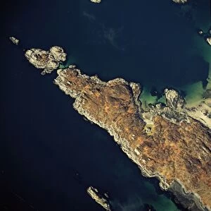
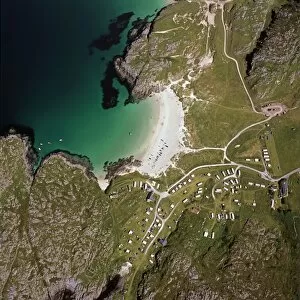
Aerial image of Scotland, UK: Aerial image of Scotland, UK: Ardnambuth beach and peninsula, Lochailort, HighlandAW-6832 Aerial image of Scotland, UK: Aerial image of Scotland, UK: Ardnambuth beach and peninsula Lochailort, Highland, Scotland Adrian Warren contact details: prints@ardea.com tel
Aerial image of Scotland, UK: Achmelvich (Gaelic: Achadh Mhealbhaich), a settlement situated, near Lochinver, HighlandAW-6830 Aerial image of Scotland, UK: Achmelvich (Gaelic: Achadh Mhealbhaich) a settlement situated, near Lochinver, Highland
Aerial view of Mount Kukenaam (Kukenan, Kukenan, Cuguenan), eastern cliff, Venezuela, South AmericaAW-6715 Aerial view of Mount Kukenaam (Kukenn, Kukenan, Cuguenan) eastern cliff, Venezuela, South America tepui Adrian Warren Please note that prints are for personal display purposes only
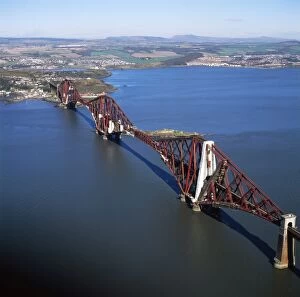
Aerial image of Scotland, UK: The Forth Bridge (Forth Rail Bridge or Forth Railway Bridge), a cantileverAW-6889 Aerial image of Scotland, UK The Forth Bridge (Forth Rail Bridge or Forth Railway Bridge), a cantilever, railway bridge over the Firth of Forth (estuary of firth) in the east of Scotland
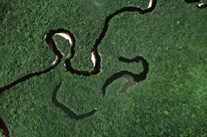
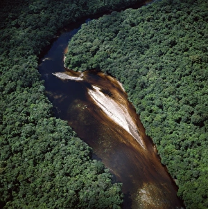
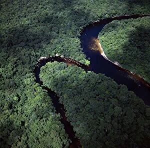
Aerial view of Rain Forest with Caroni River and Ox-Bows, Venezuela, South AmericaAW-6647 Aerial view of Rain Forest with Caroni River and Ox-Bows Venezuela, South America Adrian Warren contact details: prints@ardea.com tel: +44 (0) 20 8318 1401
Aerial image of Guyana, South America: Paikwa River, Upper Mazaruni District, riverbend and sandbarsAW-6651 Aerial image of Guyana, South America Paikwa River, Upper Mazaruni District, riverbend and sandbars Adrian Warren contact details: prints@ardea.com tel: +44 (0) 20 8318 1401
Aerial view of Rain Forest, Caroni River with sandbars, Venezuela, South AmericaAW-6646 Aerial view of Rain Forest, Caroni River with sandbars Venezuela, South America Adrian Warren contact details: prints@ardea.com tel: +44 (0) 20 8318 1401
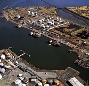
Aerial image of Scotland, UK: Grangemouth Docks and Grangemouth oil refineryAW-6897 Aerial image of Scotland, UK Grangemouth Docks and Grangemouth oil refinery Adrian Warren contact details: prints@ardea.com tel: +44 (0) 20 8318 1401
Aerial image of Guyana, South America: Kako River, Upper Mazaruni DistrictAW-6650 Aerial image of Guyana, South America Kako River, Upper Mazaruni District Adrian Warren contact details: prints@ardea.com tel: +44 (0) 20 8318 1401
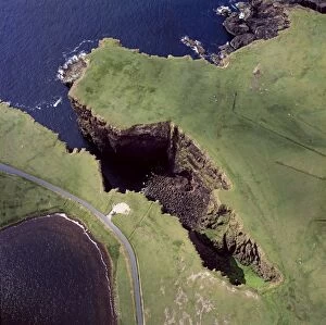
Aerial image of Scotland, UK: Volcanic Cliffs, just North east of Esha Ness (Eshaness), Northmavine peninsulaAW-6883 Aerial image of Scotland, UK Volcanic Cliffs, just North east of Esha Ness (Eshaness), Northmavine peninsula, Shetland Islands
Aerial image of Scotland, UK: Fort William, the largest town in the highlands of ScotlandAW-6888 Aerial image of Scotland, UK Fort William, the largest town in the highlands of Scotland, lies at the southern end of the Great Glen
Aerial image of Guyana, South America: confluence of Paikwa River with Kako River, Upper Mazaruni DistrictAW-6652 Aerial image of Guyana, South America confluence of Paikwa River with Kako River, Upper Mazaruni District Adrian Warren contact details: prints@ardea.com tel: +44 (0) 20 8318 1401
Aerial image of Scotland, UK: Ruined Church, Eynhallow, a small uninhabited island lies in Eynhallow Sound betweenAW-6884 Aerial image of Scotland, UK Ruined Church, Eynhallow, a small uninhabited island lies in Eynhallow Sound between Mainland, Orkney and Rousay, Orkney Islands
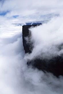
Aerial View of Mount Kukenaam (Kukenan, Kukenan, Cuguenan), Venezuela, South AmericaAW-6718 Aerial View of Mount Kukenaam (Kukenan, Kukenan, Cuguenan) Venezuela, South America Adrian Warren contact details: prints@ardea.com tel: +44 (0) 20 8318 1401
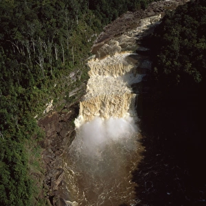
Aerial image of Guyana, South America: Peaima Falls, Upper Mazaruni RiverAW-6659 Aerial image of Guyana South America: Peaima Falls, Upper Mazaruni River Adrian Warren contact details: prints@ardea.com tel: +44 (0) 20 8318 1401
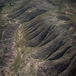
Aerial Viw of Guyana, South America: highland savannah and erosion, near Ireng River, Rupununi DistrictAW-6657 Aerial Viw of Guyana, South America highland savannah and erosion, near Ireng River, Rupununi District Adrian Warren contact details: prints@ardea.com tel: +44 (0) 20 8318 1401
Aerial image of Angel Falls and Mount Auyantepui (Auyantepuy, Devil's Mountain), Tepuis, Venezuela, South AmricaAW-6677 Aerial image of Angel Falls and Mount Auyantepui (Auyantepuy, Devil's Mountain) Tepuis, Venezuela, South America Canaima National Park UNESCO World Heritage site Adrian Warren contact
Aerial image of Scotland, UK: Glamis Castle, was the childhood home of Elizabeth Bowes-Lyon (the Queen Mother)AW-6892 Aerial image of Scotland, UK Glamis Castle, was the childhood home of Elizabeth Bowes-Lyon (the Queen Mother), village of Glamis, Angus
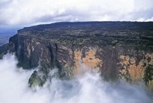
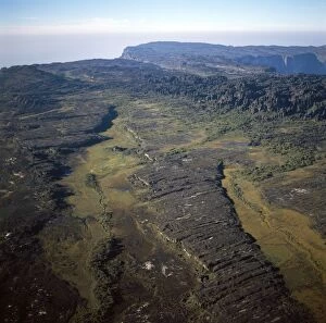
Aerial image of Tepuis, Venezuela, South America: Mount Roraima, swamps and rock labyrinths on summit plateau inAW-6698 Aerial image of Tepuis, Venezuela, South America Mount Roraima, swamps and rock labyrinths on summit plateau in Brazilian and Guyanese sectors Adrian Warren contact details
Sandhill Cranes - roosting along Platte River in early morning - Nebraska - Spring migration - March B8150TOM-1864 Sandhill Cranes - roosting along Platte River in early morning Nebraska - Spring migration - March Grus canadensis Tom & Pat Leeson contact details: prints@ardea.com tel
Aerial image of Scotland, UK: Dunnideer Castle, a 13th century tower houseAW-6874 Aerial image of Scotland, UK Dunnideer Castle, a 13th century tower house, built partially from the remains of an existing vitrified hill fort, Aberdeenshire, Scotland
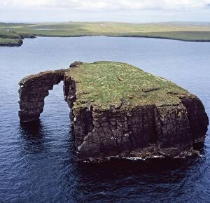
Aerial image of Scotland, UK: Dore Holm, a small islet with a natural arch, off the south coast of Esha NessAW-6880 Aerial image of Scotland, UK Dore Holm, a small islet with a natural arch, off the south coast of Esha Ness, in the west of Mainland
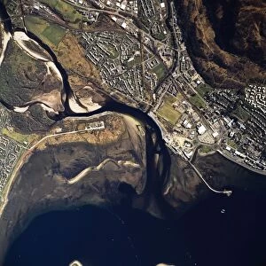
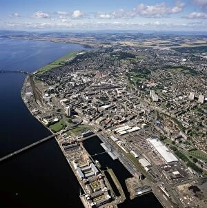
Aerial image of Scotland, UK: Dundee City, the fourth-largest city in ScotlandAW-6873 Aerial image of Scotland, UK Dundee City, the fourth-largest city in Scotland, on the north bank of the River Tay's estuary, Lowlands
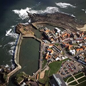
Aerial image of Scotland, UK: Dunbar, a town in East Lothian on the southeast coast of ScotlandAW-6870 Aerial image of Scotland, UK Dunbar, a town in East Lothian on the southeast coast of Scotland Adrian Warren contact details: prints@ardea.com tel: +44 (0) 20 8318 1401
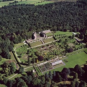
Aerial image of Scotland, UK: Drummond Castle and one of Scotland's finest Italian Renaissance style formalAW-6868 Aerial image of Scotland, UK Drummond Castle and one of Scotland's finest Italian Renaissance style formal gardens, south of Crieff
Aerial image of Scotland, UK: Corra-Bheinn, Isle of Mull, Argyll and Bute, Inner HebridesAW-6867 Aerial image of Scotland, UK: Corra-Bheinn, Isle of Mull, Argyll and Bute, Inner Hebrides Adrian Warren contact details: prints@ardea.com tel: +44 (0) 20 8318 1401
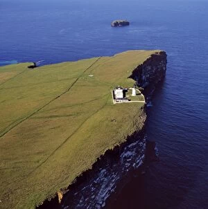
Aerial image of Scotland, UK: Lighthouse at Copinsay, Orkney MainlandAW-6866 Aerial image of Scotland, UK: Lighthouse at Copinsay, Orkney Mainland Adrian Warren contact details: prints@ardea.com tel: +44 (0) 20 8318 1401
Aerial image of Scotland, UK: Dun Carloway, Carloway, on the west coast of the Isle of LewisAW-6861 Aerial image of Scotland, UK: Dun Carloway, Carloway, on the west coast of the Isle of Lewis, Outer Hebrides a remarkably well preserved Iron Age Broch
Aerial image of Scotland, UK: Clickimin broch, Lerwick, Shetland IslandsAW-6864 Aerial image of Scotland, UK: Clickimin broch, Lerwick, Shetland Islands a large and well preserved Iron Age broch in Scotland which contained a later wheelhouse
Aerial image of Scotland, UK: Callanish Standing Stones, Callanais, Isle of Lewis and HarrisAW-6860 Aerial image of Scotland, UK: Callanish Standing Stones, Callanais, Isle of Lewis and Harris, Outer Hebrides a group of stones that date from the late Stone Age and early Bronze Age
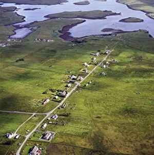
Aerial image of Scotland, UK: Callanish, a village (township), situated on a headland jutting into a sea lochAW-6859 Aerial image of Scotland, UK: Callanish, a village (township), situated on a headland jutting into a sea loch Loch Roag, near Stornoway, West Side of the Isle of Lewis, Outer Hebrides
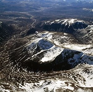
Aerial image of Scotland, UK: Cairn Toul (Hill of the barn) of The Cairngorms, the fourth highest mountain in ScotlandAW-6858 Aerial image of Scotland, UK: Cairn Toul (Hill of the barn) of The Cairngorms the fourth highest mountain in Scotland, surpassed only by Ben Nevis, Ben Macdui and Braeriach
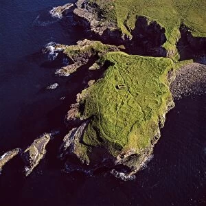
Aerial image of Scotland, UK: Brough of Deerness, Mull Head, Mainland Orkney - Remains of a 10th century chapel in aAW-6855 Aerial image of Scotland, UK: Brough of Deerness, Mull Head, Mainland Orkney Remains of a 10th century chapel in a spectacular headland setting on the eastern tip of Deerness
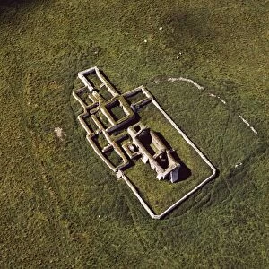
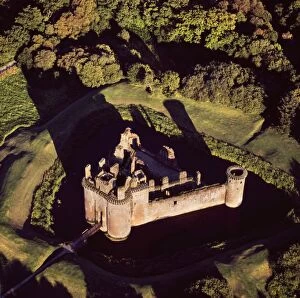
Aerial image of Scotland, UK: Caerlaverock Castle, a 13th-century triangular moated castle in the Caerlaverock NationalAW-6856 Aerial image of Scotland, UK: Caerlaverock Castle a 13th-century triangular moated castle in the Caerlaverock National Nature Reserve area at the Solway Firth, Glencaple
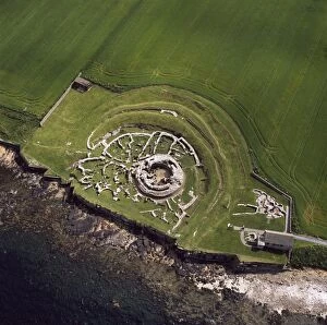
Aerial image of Scotland, UK: The Broch of Gurness, an Iron Age broch with a surrounding settlement on the northwestAW-6854 Aerial image of Scotland, UK: The Broch of Gurness an Iron Age broch with a surrounding settlement on the northwest coast of Mainland Orkney Adrian Warren contact details
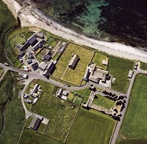
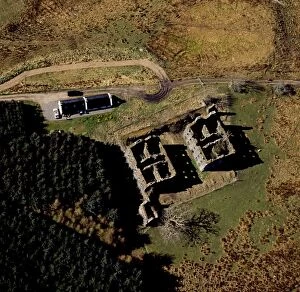
Aerial image of Scotland, UK: Earl's Palace, Birsay, a 16th century ruined castleAW-6850 Aerial image of Scotland, UK: Earl's Palace, Birsay, a 16th century ruined castle north west corner of Mainland Orkney Adrian Warren contact details: prints@ardea.com tel
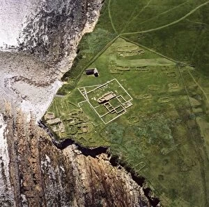
Aerial image of Scotland, UK: Brough of Birsay, a small uninhabited tidal island off the north west coast of MainlandAW-6849 Aerial image of Scotland, UK: Brough of Birsay, a small uninhabited tidal island off the north west coast of Mainland Orkney, north west coast of Orkney Mainland
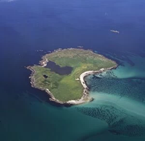
Aerial image of Scotland, UK: Boreray, an island in the Outer Hebrides, lies 2km north of North UistAW-6852 Aerial image of Scotland, UK: Boreray, an island in the Outer Hebrides lies 2km north of North Uist, West Coast Scotland. The island is dominated by Loch Mr ('big loch')
Aerial image of Scotland, UK: Bernera Barracks, Glenelg, HighlandAW-6846 Aerial image of Scotland, UK Bernera Barracks, Glenelg, Highland Adrian Warren contact details: prints@ardea.com tel: +44 (0) 20 8318 1401
Aerial image of Scotland, UK: Castle Law, an Iron Age hill fort, sits above the confluence of the River TayAW-6829 Aerial image of Scotland, UK: Castle Law, an Iron Age hill fort, sits above the confluence of the River Tay and River Earn Abernethy
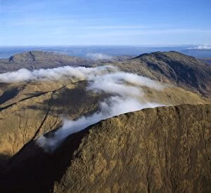
Aerial image of Scotland, UK: Summit of Ben Nevis (Scottish Gaelic: Beinn Nibheis)AW-6845 Aerial image of Scotland, UK: Summit of Ben Nevis (Scottish Gaelic: Beinn Nibheis) the highest mountain in Great Britain
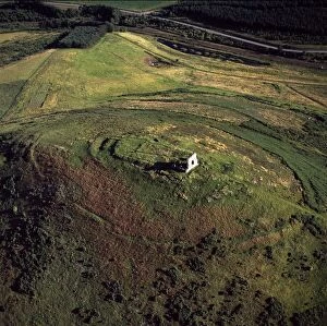
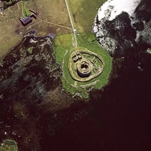
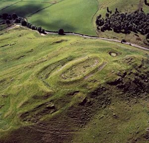
Aerial image of Scotland, UK: Hill of Barra, an Iron Age hill fort withtraces of mediaeval ridgeAW-6839 Aerial image of Scotland, UK: Hill of Barra an Iron Age hill fort with traces of medieval ridge and furrow cultivation
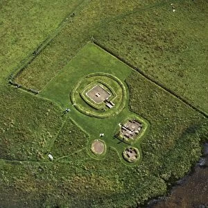
Aerial image of Scotland, UK: The Neolithic Barnhouse Settlement, sited by the shore of Loch of HarrayAW-6838 Aerial image of Scotland, UK: The Neolithic Barnhouse Settlement sited by the shore of Loch of Harray, Orkney Mainland
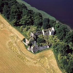
Aerial image of Scotland, UK: Ballinbreich Castle (Chapel Hill, Chapel Of Glenduchie) by the river Tay, FifeAW-6836 Aerial image of Scotland, UK: Ballinbreich Castle (Chapel Hill, Chapel Of Glenduchie) by the river Tay, Fife Adrian Warren contact details: prints@ardea.com tel: +44 (0) 20 8318 1401
Aerial image of Scotland, UK: Ardnambuth beach, Lochailort, Highland, ScotlandAW-6833 Aerial image of Scotland, UK Ardnambuth beach, Lochailort, Highland, Scotland Adrian Warren contact details: prints@ardea.com tel: +44 (0) 20 8318 1401