mail_outline sales@mediastorehouse.com
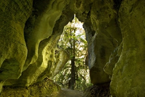
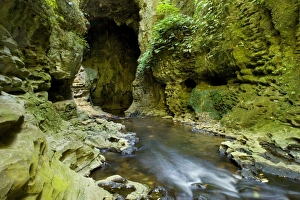
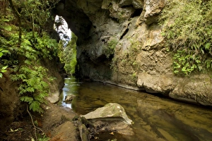
Limestone Tunnel a narrow path leads through a cave-like tunnel of limestone Ruakuri Bush and Scenic Reserve, WaitomoSAS-885 Limestone Tunnel - a narrow path leads through a cave-like tunnel of limestone Ruakuri Bush and Scenic Reserve, Waitomo, King Country, North Island
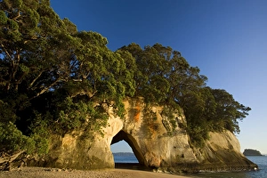
Cathedral Cove tree-clad cliff with a natural rock arch seen from beach at Cathedral Cove Cathedral CoveSAS-877 Cathedral Cove - tree-clad cliff with a natural rock arch seen from beach at Cathedral Cove Cathedral Cove, Coromandel Peninsula, North Island
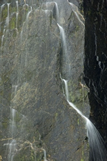
Cascades water falling down nearly vertical cliff creating many tiny cascades Franz Josef GlacierSAS-868 Cascades - water falling down nearly vertical cliff creating many tiny cascades Franz Josef Glacier, Westland National Park, West Coast, South Island
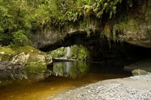
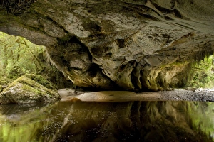
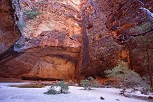
Moria Gate Arch and picturesque Oparara river located amidst lush and untouched native rainforest Oparara BasinSAS-866 Moria Gate Arch - and picturesque Oparara river located amidst lush and untouched native rainforest Oparara Basin, Karamea region, West Coast, South Island
Limestone Tunnel river flows through a deep and narrow gorge into a cave-like limestone tunnel Ruakuri BushSAS-861 Limestone Tunnel - river flows through a deep and narrow gorge into a cave-like limestone tunnel Ruakuri Bush and Scenic Reserve, Waitomo, King Country, North Island
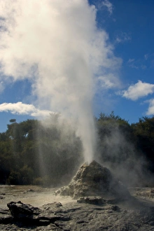
Lady Knox Geyser erupting Geyser spewing water and steam in the blue sky Waiotapu Thermal Area, Rotorua, North IslandSAS-860 Lady Knox Geyser - erupting Geyser spewing water and steam in the blue sky Waiotapu Thermal Area, Rotorua, North Island
Moria Gate Arch and picturesque Oparara river seen from the inside of the arch which is actually more a cave OpararaSAS-858 Moria Gate Arch - and picturesque Oparara river seen from the inside of the arch which is actually more a cave Oparara Basin, Karamea region, West Coast, South Island
Natural Bridge natural limestone arch and brook at Mangapohoe Natural Bridge Waitomo, King Country, North IslandSAS-853 Natural Bridge - natural limestone arch and brook at Mangapohoe Natural Bridge Waitomo, King Country, North Island
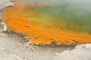
The Champagne Pool a colourful hot spring in Waiotapu geothermal area. The surface temperature of this big spring is 74SAS-838 The Champagne Pool - a colourful hot spring in Waiotapu geothermal area. The surface temperature of this big spring is 74 C and it bubbles due to uprising carbon dioxide
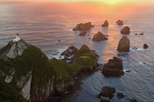
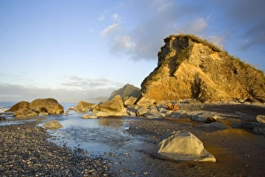
Nugget Point sea stacks called nuggets and Nugget Point Lighthouse facing towards rising sun Catlins, SouthlandSAS-831 Nugget Point - sea stacks called nuggets and Nugget Point Lighthouse facing towards rising sun Catlins, Southland, South Island
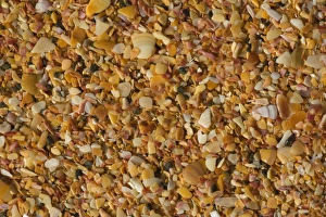
Shell beach the beach at Cable Bay is made up of uncountable tiny fragments of shells in lots of different coloursSAS-817 Shell beach - the beach at Cable Bay is made up of uncountable tiny fragments of shells in lots of different colours and hues
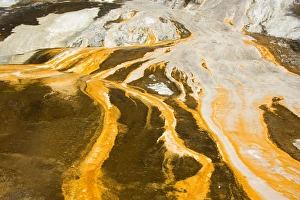
Emerald Terrace colourful silica terrace formed by hot water algae growing in the geothermal area of Orakei Korako alsoSAS-784 Emerald Terrace - colourful silica terrace formed by hot water algae growing in the geothermal area of Orakei Korako also called The Hidden Valley Orakei Korako, Waikato, North Island
Shoreline cliffs and rocks at Gillespies Beach in last evening light Westland National Park, West Coast, South IslandSAS-782 Shoreline - cliffs and rocks at Gillespies Beach in last evening light Westland National Park, West Coast, South Island
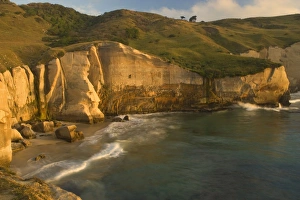
Seascape Tunnel Beach and surrounding cliffs just after sunrise Tunnel Beach, Coastal Otago, South Island, New ZealandSAS-778 Seascape - Tunnel Beach and surrounding cliffs just after sunrise Tunnel Beach, Coastal Otago, South Island, New Zealand Steffen & Alexandra Sailer Please note that prints are for personal
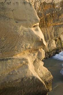
Cliff Face sandstone cliff which's shape looks like the profile of a man's face complete with eyes, noseSAS-758 Cliff Face - sandstone cliff which's shape looks like the profile of a man's face complete with eyes, nose, mouth and chin Tunnel Beach, Otago, South Island
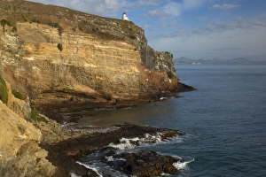
Taiaroa Head cliffs of Taiaroa Head with Taiaroa Head Lighthouse. On the tip of the cliff around the lighthouse isSAS-755 Taiaroa Head - cliffs of Taiaroa Head with Taiaroa Head Lighthouse. On the tip of the cliff around the lighthouse is the only mainland breeding colony of the Royal Albatross
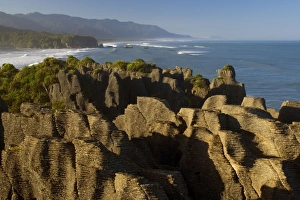
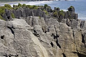
Pancake Rocks famous flat limestone rock formations at Punakaiki with rainforest-clad coastline Paparoa National ParkSAS-751 Pancake Rocks - famous flat limestone rock formations at Punakaiki with rainforest-clad coastline Paparoa National Park, West Coast, South Island
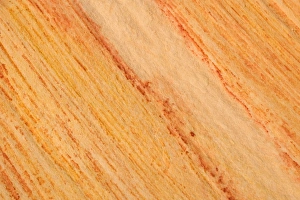
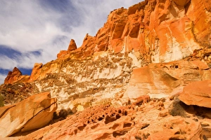
colourful sandstone - detail of a coloured sandstone rock. The colours range from yellow to orange and dark redSAS-1143 colourful sandstone - detail of a coloured sandstone rock. Rainbow Valley, Simpson Desert area, Northern Territory
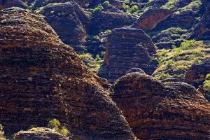
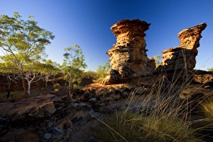
Sandstone Domes - famous banded, beehive-shaped domes, the world's most exceptional example of cone karstSAS-1142 Sandstone Domes - famous banded, beehive-shaped domes, the world's most exceptional example of cone karst formations Bungle Bungle National Park, Purnululu National Park
Domes and Piccaninny creek - famous, banded sandstone domes and dried-up riverbed of Piccaninny Creek - Bungle BungleSAS-1141 Domes and Piccaninny creek - famous, banded sandstone domes and dried-up riverbed of Piccaninny Creek Bungle Bungle National Park, Purnululu National Park, Western Australia
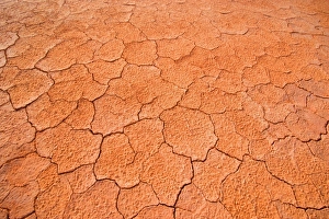
Dried-up earth - the hot sun in the Simpson Desert area blazes down onto the earthSAS-1134 Dried-up earth - the hot sun in the Simpson Desert area blazes down onto the earth and dries it up until the soil cracks, creating an intricrate pattern Rainbow Valley, Simpson Desert area
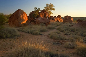
Devils Marbles - several circular shaped marbles of red granite situated amidst grassy bushland in last evening lightSAS-1132 Devils Marbles - several circular shaped marbles of red granite situated amidst grassy bushland in last evening light Devils Marbles Conservation Area, Northern Territory
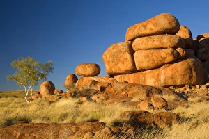
Devils Marbles - a ghost gum tree and three balanced rocks of almost perfect circular shape are located on top of aSAS-1130 Devils Marbles - a ghost gum tree and three balanced rocks of almost perfect circular shape are located on top of a rock formation, amidst grassy bushland Devils Marbles Conservation Area
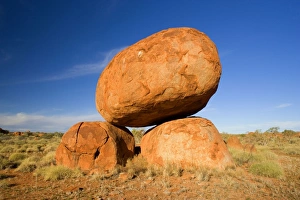
Devils Marbles - a balanced rock of red granite is situated on top of two boulders - Devils Marbles Conservation AreaSAS-1129 Devils Marbles - a balanced rock of red granite is situated on top of two boulders Devils Marbles Conservation Area, Northern Territory, Australia The Devils Marbles
Devils Marbles - two nearly perfectly circular shaped boulder of red granite balanced on bedrock - Devils MarblesSAS-1126 Devils Marbles - two nearly perfectly circular shaped boulder of red granite balanced on bedrock Devils Marbles Conservation Area, Northern Territory, Australia The Devils Marbles
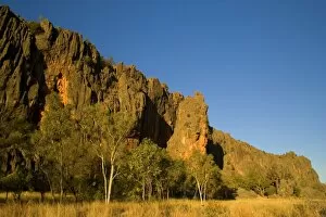
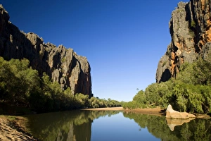
Windjana Gorge - the sheer, vertical wall of Windjana Gorge rises up abrubtly out of grassy bushland dotted with gumSAS-1120 Windjana Gorge - the sheer, vertical wall of Windjana Gorge rises up abrubtly out of grassy bushland dotted with gum trees in last evening light
Windjana Gorge - ragged entrance of Windjana Gorge which nearly dried up Lennard river seen from the insideSAS-1119 Windjana Gorge - ragged entrance of Windjana Gorge with nearly dried up Lennard river seen from the inside. The riff walls rise vertically up the sides of the river Windjana Gorge National
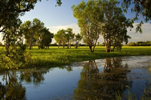
Wetlands - evening mood in a wetland with huge Paperbark trees and swamp grass reflected in a billabong (waterhole)SAS-1117 Wetlands - evening mood in a wetland with huge Paperbark trees and swamp grass reflected in a billabong (waterhole) Northern Territory
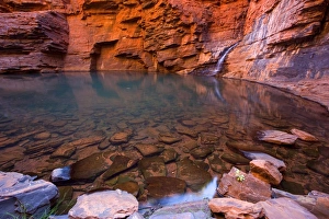
Handrail Pool - a waterfall flows into a hugh pool hidden within the steep, red and very terraced walls of Weano GorgeSAS-1116 Handrail Pool - a waterfall flows into a hugh pool hidden within the steep, red and very terraced walls of Weano Gorge
Rainbow Valley - colourful rock formation with bands of different coloured sandstoneSAS-1100 Rainbow Valley - colourful rock formation with bands of different coloured sandstone, from yellow to orange and rusty brown Rainbow Valley, Simpson Desert area, Northern Territory
Mushroom Rock view from sandstone rock formation called the mushroom onto the colourful cliffs of Rainbow ValleySAS-1092 Mushroom Rock - view from sandstone rock formation called the mushroom onto the colourful cliffs of Rainbow Valley
Lost City at sunset - ancient sandstone formations carved out by the Finke river millions of years ago - Finke GorgeSAS-1087 Lost City at sunset - ancient sandstone formations carved out by the Finke river millions of years ago Finke Gorge National Park, Northern Territory
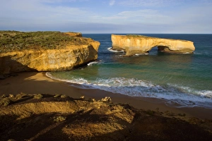
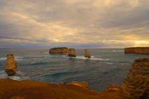
London Bridge - collapsed sandstone arch London Bridge. The force of the sea eats more and more of the rocks awaySAS-1086 London Bridge - collapsed sandstone arch London Bridge. Port Campbell National Park, Great Ocean Road, Victoria, Australia The force of the sea eats more and more of the rocks away
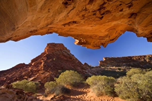
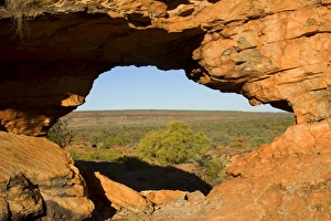
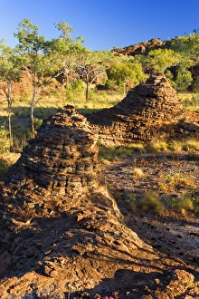
Keep River Rock formations - a window in the red rocks with a view toward the less rockier section of the NationalSAS-1079 Keep River Rock formations - a window in the red rocks with a view toward the less rockier section of the National Park
Keep River Rock formations - view from above onto beehive-shaped rock formationsSAS-1078 Keep River Rock formations - view from above onto beehive-shaped rock formations and eucalypt trees Keep River National Park, Northern Territory
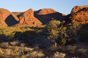
Keep River Rock formations - chimney shaped rock formations and gum trees in early morning light - Keep River NationalSAS-1077 Keep River Rock formations - chimney shaped rock formations and gum trees in early morning light Keep River National Park, Northern Territory
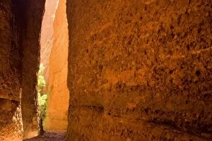
Echidna Chasm - a very narrow, enchanting slot canyon which is partly only one metre wideSAS-1055 Echidna Chasm - a very narrow, enchanting slot canyon which is partly only one metre wide. When the sun is high, it reflects on the walls
Thunderstorm over the Bay of Islands - dark clouds are gathering over sandstone rock stacks in the Bay of IslandsSAS-1043 Thunderstorm over the Bay of Islands Bay of Islands Coastal Park, Great Ocean Road, Victoria, Australia dark clouds are gathering over sandstone rock stacks in the Bay of Islands
Amphitheatre - striking amphitheatre in Cathedral Gorge which is nestled within the famous beehive-shaped domes ofSAS-1040 Amphitheatre - striking amphitheatre in Cathedral Gorge which is nestled within the famous beehive-shaped domes of the Bungle Bungles
Conglomerate rock outcrops. Tiha beach - Waitaki Waitakere Ranges - Auckland - New ZealandMAB-791 Conglomerate rock outcrops Tiha beach - Waitaki Waitakere Ranges - Auckland - New Zealand Mark Boulton Please note that prints are for personal display purposes only
Limestone outcrops on cliffs. Punakaiki South Island - New Zealand. Pancake rocks form the main focus for visitors inMAB-543 Limestone outcrops on cliffs Punakaiki South Island - New Zealand Pancake rocks form the main focus for visitors in Paparoa National Park where high outcrops of limestone have been formed by
Worthington Glacier Valdez Highway, AlaskaWS-130 WORTHINGTON GLACIER - Valdez Highway Alsaka, USA William Stribling Please note that prints are for personal display purposes only and may not be reproduced in any way
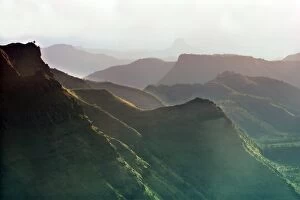
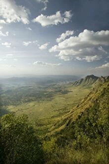
Africa - Rift Valley, Maralal, KenyaWAT-9151 Africa - Rift Valley, Maralal, Kenya M. Watson Please note that prints are for personal display purposes only and may not be reproduced in any way
Kenya - Rift Valley near town of MaralalWAT-8929 KENYA - Rift Valley near town of Maralal Africa M. Watson Please note that prints are for personal display purposes only and may not be reproduced in any way
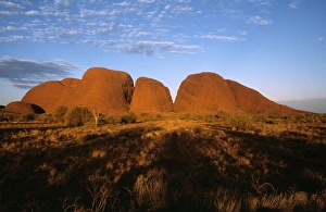
Australia - Kata Tjuta (the Olgas) Uluru-kata Tjuta National Park, Northern TerritoryWAT-2681 Australia - Kata Tjuta (the Olgas) Uluru-kata Tjuta National Park, Northern Territory. M. Watson Please note that prints are for personal display purposes only
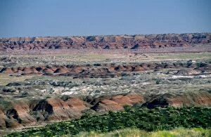
USA - Arizona - Blue Mesa Petrified Forest National Park - Painted Desert showing gully erosionWAT-2304 USA - Arizona - Blue Mesa Petrified Forest National Park Painted Desert showing gully erosion M. Watson Please note that prints are for personal display purposes only
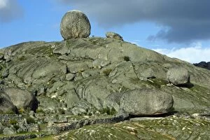
Granite Boulder Terrain - beside Valencia de Alcantara, Extremadura, SpainUSH-2856 Granite Boulder Terrain - beside Valencia de Alcantara Extremadura, Spain Duncan Usher Please note that prints are for personal display purposes only and may not be reproduced in any way
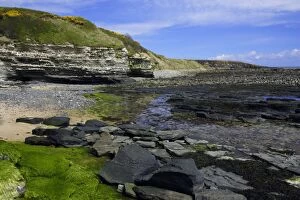
Howick Scar-at low tide, south of Craster, Northumberland NP, UKUSH-2130 Howick Scar - at low tide south of Craster, Northumberland NP, UK Duncan Usher Please note that prints are for personal display purposes only and may not be reproduced in any way