mail_outline sales@mediastorehouse.com
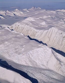
Aerial - Glacier - Admiralty Mountain - Transantarctic Mountains, Antarctica JPF48796JPF-14387 Aerial - Glacier - Admiralty Mountain Transantarctic Mountains, Antarctica Jean-Paul Ferrero Please note that prints are for personal display purposes only
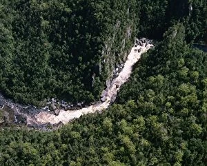
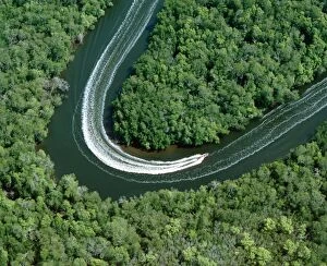
Aerial - Gordon River Franklin - Gordon Wild Rivers National Park, Tasmania, Australia JPF49316JPF-14384 Aerial - Gordon River Franklin Gordon Wild Rivers National Park, Tasmania, Australia Jean-Paul Ferrero Please note that prints are for personal display purposes only
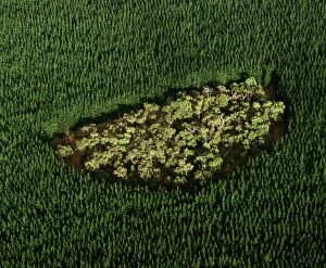
Remnant of native forest in pine plantation - near Mount Gambier, South Australia JPF49482JPF-14382 Remnant of native forest in pine plantation near Mount Gambier, South Australia Jean-Paul Ferrero Please note that prints are for personal display purposes only
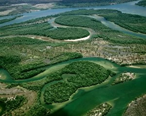
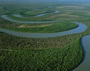
Aerial - Archer River - Gulf of Carpentaria, Cape York Peninsula, Queensland, Australia JPF49961JPF-14379 Aerial - Archer River Gulf of Carpentaria, Cape York Peninsula, Queensland, Australia Jean-Paul Ferrero Please note that prints are for personal display purposes only
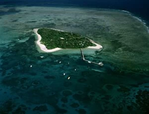
Aerial - Green Island - Green Island National Park, Great Barrier Reef off Cairns, Queensland, Australia JPF50168JPF-14377 Aerial - Green Island Green Island National Park, Great Barrier Reef off Cairns, Queensland, Australia Jean-Paul Ferrero Please note that prints are for personal display purposes only
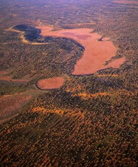
Aerial - Playas/claypans and low dunes the most vegetated and largest sand dune desert in AustraliaJPF-14373 Aerial - Playas/claypans and low dunes the most vegetated and largest sand dune desert in Australia Maralinga-Tjarutja Aboriginal lands - near Lake Meramangye, Great Victoria Desert
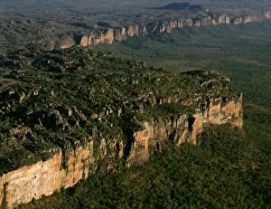
Aerial - Arnhem Land Escarpment - Kakadu National Park (World Heritage Area) - Northern Territory, Australia JPF47969JPF-14372 Aerial - Arnhem Land Escarpment Kakadu National Park (World Heritage Area) - Northern Territory, Australia Jean-Paul Ferrero Please note that prints are for personal display purposes only
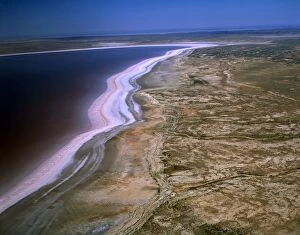
Aerial - Lake Gairdner - salt lake, South Australia JPF47601JPF-14370 Aerial - Lake Gairdner - salt lake South Australia Jean-Paul Ferrero Please note that prints are for personal display purposes only and may not be reproduced in anyway
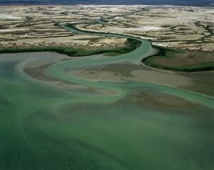
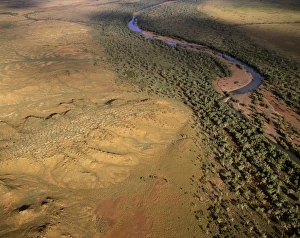
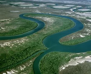
Aerial - McArthur River near delta Gulf of Carpentaria, Northern Territory, Australia JPF48204JPF-14368 Aerial - McArthur River near delta Gulf of Carpentaria Northern Territory, Australia Jean-Paul Ferrero Please note that prints are for personal display purposes only
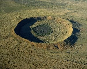
Aerial - Wolfe Creek meteor crater - 25 million years old, Wolfe Creek Crater National Park, Kimberley regionJPF-14352 Aerial - Wolfe Creek meteor crater - 25 million years old Wolfe Creek Crater National Park, Kimberley region, Western Australia Jean-Paul Ferrero Please note that prints are for personal
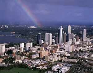
Aerial - Rainbow over Perth, Western Australia JPF46414JPF-14349 Aerial - Rainbow over Perth Western Australia Jean-Paul Ferrero Please note that prints are for personal display purposes only and may not be reproduced in anyway
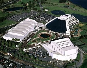
Aerial - Burwood Casino - Perth, Western Australia JPF46403JPF-14348 Aerial - Burwood Casino Perth, Western Australia Jean-Paul Ferrero Please note that prints are for personal display purposes only and may not be reproduced in anyway
Aerial - Lake Eyre North Dry salt lake that floods a few times each centuryJPF-14347 Aerial - Lake Eyre North Dry salt lake that floods a few times each century Jackboot Bay, along Hunt Peninsula (Elliot Price Conservation Park) Lake Eyre National Park
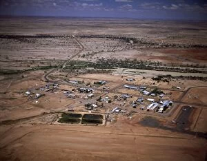
Aerial - Birdsville - Queensland, Australia JPF41526JPF-14305 Aerial - Birdsville - Queensland, Australia Jean-Paul Ferrero Please note that prints are for personal display purposes only and may not be reproduced in anyway
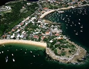
Aerial - Camp Cove, Laings Point and Watsons Bay - Sydney Harbour, New South Wales, Australia JPF45384JPF-14345 Aerial - Camp Cove, Laings Point and Watsons Bay Sydney Harbour, New South Wales, Australia Jean-Paul Ferrero Please note that prints are for personal display purposes only
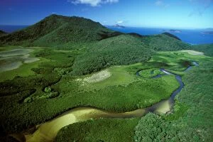
Aerial - Hill Inlet with mangroves, Whitsunday Island Whitsunday Group, Great Barrier Reef Marine ParkJPF-14302 Aerial - Hill Inlet with mangroves Whitsunday Island Whitsunday Group, Great Barrier Reef Marine Park (World Heritage Area), Queensland
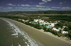
Aerial of Beach - Sheraton Mirage - Port Douglas, North Queensland, Australia JPF23194JPF-14251 Aerial of Beach Sheraton Mirage - Port Douglas, North Queensland, Australia Jean-Paul Ferrero Please note that prints are for personal display purposes only
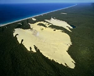
Aerial - Lake Wabby deepest perched lake, being engulfed by sand dune, Fraser Island, Queensland, Australia JPF34171JPF-14296 Aerial - Lake Wabby deepest perched lake, being engulfed by sand dune Fraser Island, Queensland, Australia Jean-Paul Ferrero Please note that prints are for personal display purposes only
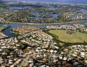
Aerial - Robina and Mermaid Waters Gold Coast, Queensland JPF46582JPF-14346 Aerial - Robina and Mermaid Waters Gold Coast, Queensland, Australia Jean-Paul Ferrero Please note that prints are for personal display purposes only and may not be reproduced in anyway
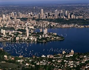
Aerial - Sydney - with Double Bay in foreground Sydney, New South Wales, Australia JPF47089JPF-14343 Aerial - Sydney - with Double Bay in foreground Sydney, New South Wales, Australia Jean-Paul Ferrero Please note that prints are for personal display purposes only
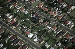
Aerial view of Campbelltown Greater Sydney, New South Wales, Australia JPF09410JPF-14217 Aerial view of Campbelltown Greater Sydney, New South Wales, Australia Jean-Paul Ferrero Please note that prints are for personal display purposes only and may not be reproduced in anyway
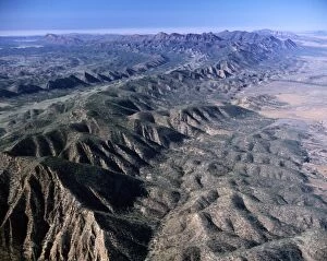
Aerial: south of Brachina Gorge Flinders Ranges National Park, South Australia JPF41752JPF-14329 Aerial: south of Brachina Gorge Flinders Ranges National Park, South Australia Jean-Paul Ferrero Please note that prints are for personal display purposes only
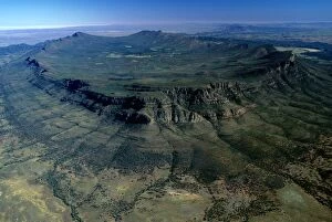
Aerial - Wilpena Pound Flinders Ranges National Park, South Australia JPF42901JPF-14340 Aerial - Wilpena Pound Flinders Ranges National Park, South Australia Jean-Paul Ferrero Please note that prints are for personal display purposes only and may not be reproduced in anyway
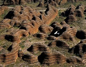
Aerial - Bungle Bungle Range & plane Sandstone range formed 400 million years ago from layered sediments washed into aJPF-14315 Aerial - Bungle Bungle Range & plane Sandstone range Purnululu National Park, Kimberley region, Western Australia Formed 400 million years ago from layered sediments washed into a rift
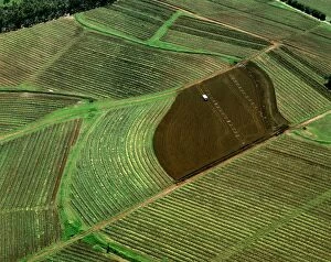
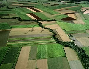
Aerial: vineyards Hunter Valley, New South Wales, Australia JPF53017JPF-13991 Aerial: vineyards Hunter Valley New South Wales, Australia Jean-Paul Ferrero Please note that prints are for personal display purposes only and may not be reproduced in anyway
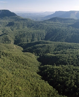
Jamison Valley Blue Mountains National Park, New South Wales, Australia JPF00369JPF-14029 Jamison Valley Blue Mountains National Park New South Wales, Australia Jean-Paul Ferrero Please note that prints are for personal display purposes only and may not be reproduced in anyway
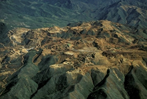
Aerial - Landscape damaged by nickel mining Thio, east coast New Caledonia, Melanesia JPF52552JPF-13974 Aerial - Landscape damaged by nickel mining Thio, east coast New Caledonia, Melanesia Jean-Paul Ferrero Please note that prints are for personal display purposes only
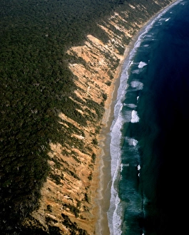
Aerial - Sand cliffs - Cooloolah Section, Great Sandy National Park, Queensland, Australia JPF52892JPF-13992 Aerial - Sand cliffs - Cooloolah Section Great Sandy National Park, Queensland, Australia Jean-Paul Ferrero Please note that prints are for personal display purposes only
Fishing boat on mangrove-lined inlet, Kennedy Inlet, Newcastle Bay Cape York Peninsula, Queensland, Australia JPF52242JPF-13959 Fishing boat on mangrove-lined inlet, Kennedy Inlet Newcastle Bay Cape York Peninsula, Queensland, Australia Jean-Paul Ferrero Please note that prints are for personal display purposes only
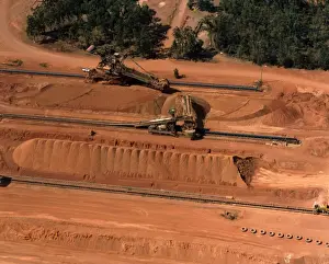
Aerial - Bauxite mining used in aluminium manufacture Weipa, Cape York, Queensland, Australia JPF52276JPF-13963 Aerial - Bauxite mining used in aluminium manufacture Weipa, Cape York, Queensland, Australia Jean-Paul Ferrero Please note that prints are for personal display purposes only
Aerial - Pattern of sand dunes south of Hat Head aerial, New South Wales, Australia JPF52864JPF-13994 Aerial - Pattern of sand dunes south of Hat Head aerial, New South Wales, Australia Jean-Paul Ferrero Please note that prints are for personal display purposes only
Aerial - Sand dunes near Ayers Rock / Uluru Uluru-Kata Tjuta National Park (World Heritage Area), Northern TerritoryJPF-13995 Aerial - Sand dunes near Ayers Rock / Uluru Uluru-Kata Tjuta National Park (World Heritage Area) Northern Territory
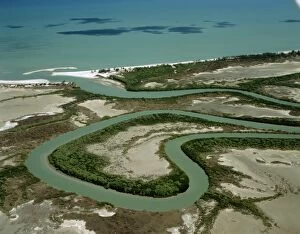
Aerial - North Kennedy River with mangrove-lined banks, Lakefield National Park, far north QueenslandJPF-13956 Aerial - North Kennedy River with mangrove-lined banks Lakefield National Park, far north Queensland, Australia Jean-Paul Ferrero Please note that prints are for personal display purposes
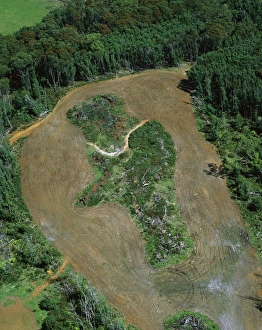
Logging roads & forest clearing showing loss of biodiversity near Cumberland Lake, West coast, TasmaniaJPF-13955 Logging roads & forest clearing showing loss of biodiversity near Cumberland Lake West coast, Tasmania, Australia Jean-Paul Ferrero Please note that prints are for personal display purposes
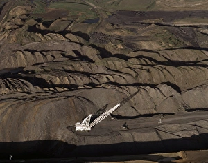
Aerial - Curragh open cut coal mine north of Blackwater, Queensland, Australia JPF52264JPF-13962 Aerial - Curragh open cut coal mine north of Blackwater Queensland, Australia Jean-Paul Ferrero Please note that prints are for personal display purposes only
Oakover River aerial, near Great Sandy Desert, east of Isabella Range, Western Australia JPF52504JPF-13973 Oakover River aerial, near Great Sandy Desert, east of Isabella Range Western Australia Jean-Paul Ferrero Please note that prints are for personal display purposes only
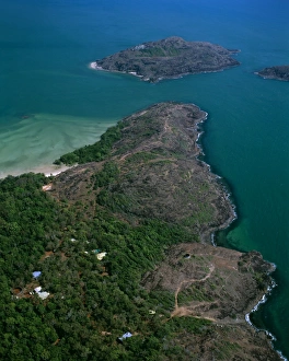
Aerial - Tip of Cape York with Cape York Island beyond and Eborac Island on rightJPF-13972 Aerial - Tip of Cape York with Cape York Island beyond and Eborac Island on right, northernmost point of continental Australia, Cape York Peninsula, Queensland
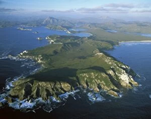
Aerial - Port Davey, Hilliard Head, Stephens Bay, Mt Rugby beyond Southwest National ParkJPF-13835 Aerial - Port Davey, Hilliard Head, Stephens Bay, Mt Rugby beyond Southwest National Park Tasmania (World Heritage Area)
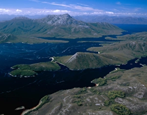
Aerial - Bathurst Channel, Pim Point, Mt Rugby and Bathurst Harbour Southwest National ParkJPF-13838 Aerial - Bathurst Channel, Pim Point, Mt Rugby and Bathurst Harbour Southwest National Park Tasmania (World Heritage Area)
Aerial - Duck Creek, Gulf of Carpentaria Cape York Peninsula, Queensland, Australia JPF50098JPF-13863 Aerial - Duck Creek Gulf of Carpentaria Cape York Peninsula, Queensland, Australia Jean-Paul Ferrero Please note that prints are for personal display purposes only
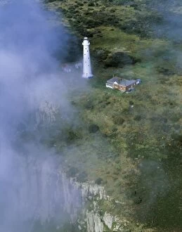
Aerial - Tasman Island and lighthouse Tasman Peninsula, Tasmania, AustraliaJPF-13854 Aerial - Tasman Island and lighthouse Tasman Peninsula Tasmania, Australia Jean-Paul Ferrero Please note that prints are for personal display purposes only
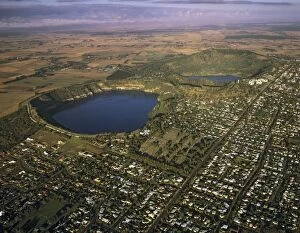
Aerial - Mount Gambier and Blue Lake South Australia JPF49542JPF-13844 Aerial - Mount Gambier and Blue Lake South Australia Jean-Paul Ferrero Please note that prints are for personal display purposes only and may not be reproduced in anyway
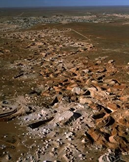
Aerial - Opal mining from the air, and town of Coober Pedy beyond - South Australia JPF51910JPF-13919 Aerial - Opal mining from the air and town of Coober Pedy beyond - South Australia Jean-Paul Ferrero Please note that prints are for personal display purposes only
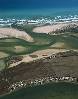
Aerial - Murray River mouth & Hindmarsh island, with Younghusband Pneinsula & Sir Richard Peninsula South AustraliaJPF-13858 Aerial - Murray River mouth & Hindmarsh island, with Younghusband Peninsula & Sir Richard Peninsula South Australia Jean-Paul Ferrero Please note that prints are for personal display
Aerial - Canefields near Cairns North Queensland, Australia JPF50155JPF-13860 Aerial - Canefields near Cairns North Queensland, Australia Jean-Paul Ferrero Please note that prints are for personal display purposes only and may not be reproduced in anyway
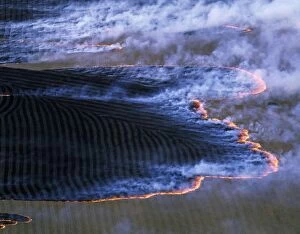
Fire (burning-off) Southern Australia, February, Tasmania JPF49472JPF-13846 Fire (burning-off) Southern Australia February, Tasmania Jean-Paul Ferrero Please note that prints are for personal display purposes only and may not be reproduced in anyway
Jabiluka Uranium Mine Kakadu National Park (World Heritage Area), Northern Territory, Australia JPF51440JPF-13914 Jabiluka Uranium Mine Kakadu National Park (World Heritage Area) Northern Territory, Australia Jean-Paul Ferrero Please note that prints are for personal display purposes only
Aerial - Cape York Peninsula - Nassau & Scrutton Rivers - Queensland - Australia JPF50105JPF-13861 Aerial - Cape York Peninsula Nassau & Scrutton Rivers - Queensland - Australia Jean-Paul Ferrero Please note that prints are for personal display purposes only