mail_outline sales@mediastorehouse.com
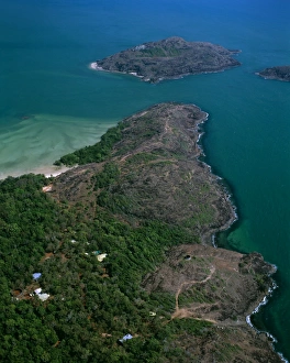
Aerial - Tip of Cape York with Cape York Island beyond and Eborac Island on rightJPF-13972 Aerial - Tip of Cape York with Cape York Island beyond and Eborac Island on right, northernmost point of continental Australia, Cape York Peninsula, Queensland
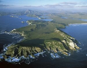
Aerial - Port Davey, Hilliard Head, Stephens Bay, Mt Rugby beyond Southwest National ParkJPF-13835 Aerial - Port Davey, Hilliard Head, Stephens Bay, Mt Rugby beyond Southwest National Park Tasmania (World Heritage Area)
Aerial - Bathurst Channel, Pim Point, Mt Rugby and Bathurst Harbour Southwest National ParkJPF-13838 Aerial - Bathurst Channel, Pim Point, Mt Rugby and Bathurst Harbour Southwest National Park Tasmania (World Heritage Area)
Aerial - Duck Creek, Gulf of Carpentaria Cape York Peninsula, Queensland, Australia JPF50098JPF-13863 Aerial - Duck Creek Gulf of Carpentaria Cape York Peninsula, Queensland, Australia Jean-Paul Ferrero Please note that prints are for personal display purposes only
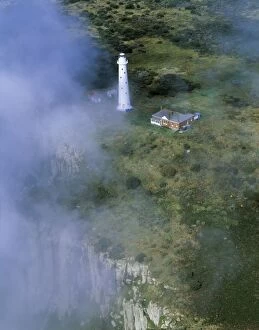
Aerial - Tasman Island and lighthouse Tasman Peninsula, Tasmania, AustraliaJPF-13854 Aerial - Tasman Island and lighthouse Tasman Peninsula Tasmania, Australia Jean-Paul Ferrero Please note that prints are for personal display purposes only
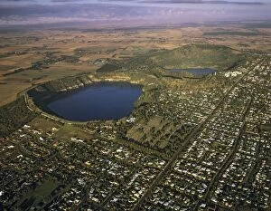
Aerial - Mount Gambier and Blue Lake South Australia JPF49542JPF-13844 Aerial - Mount Gambier and Blue Lake South Australia Jean-Paul Ferrero Please note that prints are for personal display purposes only and may not be reproduced in anyway
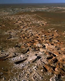
Aerial - Opal mining from the air, and town of Coober Pedy beyond - South Australia JPF51910JPF-13919 Aerial - Opal mining from the air and town of Coober Pedy beyond - South Australia Jean-Paul Ferrero Please note that prints are for personal display purposes only
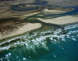
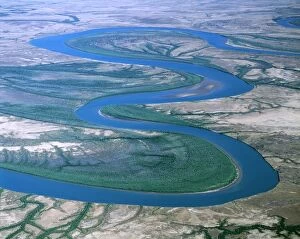
Aerial - Murray River mouth & Hindmarsh island, with Younghusband Pneinsula & Sir Richard Peninsula South AustraliaJPF-13858 Aerial - Murray River mouth & Hindmarsh island, with Younghusband Peninsula & Sir Richard Peninsula South Australia Jean-Paul Ferrero Please note that prints are for personal display
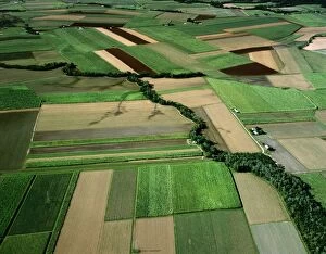
Aerial - Canefields near Cairns North Queensland, Australia JPF50155JPF-13860 Aerial - Canefields near Cairns North Queensland, Australia Jean-Paul Ferrero Please note that prints are for personal display purposes only and may not be reproduced in anyway
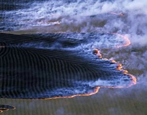
Fire (burning-off) Southern Australia, February, Tasmania JPF49472JPF-13846 Fire (burning-off) Southern Australia February, Tasmania Jean-Paul Ferrero Please note that prints are for personal display purposes only and may not be reproduced in anyway
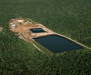
Jabiluka Uranium Mine Kakadu National Park (World Heritage Area), Northern Territory, Australia JPF51440JPF-13914 Jabiluka Uranium Mine Kakadu National Park (World Heritage Area) Northern Territory, Australia Jean-Paul Ferrero Please note that prints are for personal display purposes only
Aerial - Cape York Peninsula - Nassau & Scrutton Rivers - Queensland - Australia JPF50105JPF-13861 Aerial - Cape York Peninsula Nassau & Scrutton Rivers - Queensland - Australia Jean-Paul Ferrero Please note that prints are for personal display purposes only
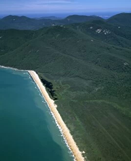
Aerial - Five Mile Beach - Wilsons Promontory National Park, Victoria, Australia JPF49704JPF-13856 Aerial - Five Mile Beach Wilsons Promontory National Park, Victoria, Australia Jean-Paul Ferrero Please note that prints are for personal display purposes only
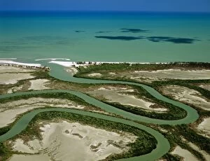
Aerial - Murray River mouth with Sir Richard Peninsula (bottom) and Younghusband Peninsula (top)JPF-13842 Aerial - Murray River mouth with Sir Richard Peninsula (bottom) and Younghusband Peninsula (top) Coorong National Park, South Australia
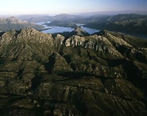
Aerial - SW Cape Mountain Range, Bathurst harbour Southwest National Park, Tasmania (World Heritage Area)JPF-13853 Aerial - SW Cape Mountain Range, Bathurst harbour Southwest National Park, Tasmania (World Heritage Area), Australia Jean-Paul Ferrero Please note that prints are for personal display
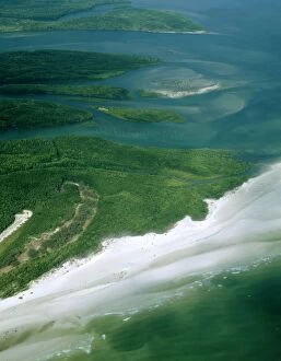
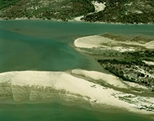
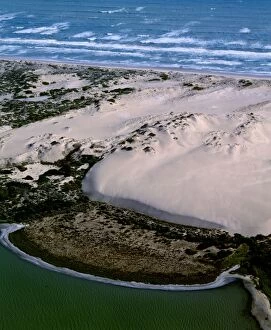
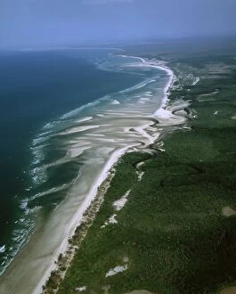
Aerial - Sandy Cape - Arthur Pieman Protected Area, Tasmania, Australia JPF49284JPF-13849 Aerial - Sandy Cape - Arthur Pieman Protected Area Tasmania, Australia Jean-Paul Ferrero Please note that prints are for personal display purposes only and may not be reproduced in anyway
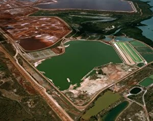
Aerial - Bauxite mine, Gove eastern Arnhemland, Northern Territory, Australia JPF49980JPF-13850 Aerial - Bauxite mine, Gove eastern Arnhemland Northern Territory, Australia Jean-Paul Ferrero Please note that prints are for personal display purposes only
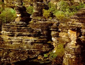
Eroded sandstone on western edge of the Arnhemland Escarpment Kombolgie FormationJPF-13884 Eroded sandstone on western edge of the Arnhemland Escarpment Kombolgie Formation: sediments deposited in early Proterozoic(1700 Ma), Ubirr, Kakadu National Park (World Heritage Area)
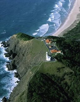
Byron Bay lighthouse - aerial, Byron Bay, New South Wales, Australia JPF48933JPF-13830 Byron Bay lighthouse - aerial Byron Bay, New South Wales, Australia Jean-Paul Ferrero Please note that prints are for personal display purposes only and may not be reproduced in anyway
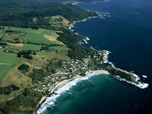
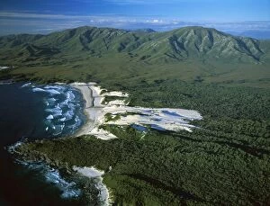
Aerial - Sisters Beach and farmland north coast Tasmania, Australia JPF49103JPF-13839 Aerial - Sisters Beach and farmland north coast Tasmania, Australia Jean-Paul Ferrero Please note that prints are for personal display purposes only and may not be reproduced in anyway
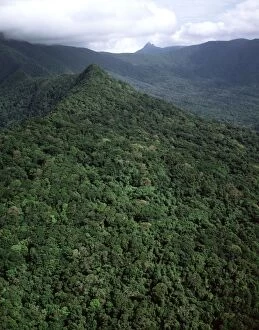
Aerial - Tropical rainforest near Cape Tribulation Daintree National Park, Queensland, Australia JPF50058JPF-13866 Aerial - Tropical rainforest near Cape Tribulation Daintree National Park Queensland, Australia Jean-Paul Ferrero Please note that prints are for personal display purposes only
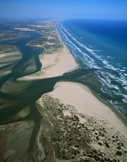
Aerial - Murray River mouth, with Sir Richard Peninsula & Younghusband Peninsula South Australia JPF49635JPF-13841 Aerial - Murray River mouth, with Sir Richard Peninsula & Younghusband Peninsula South Australia Jean-Paul Ferrero Please note that prints are for personal display purposes only
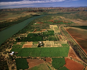
Aerial - Ord River Irrigation Scheme near Kununurra, Western Australia JPF51804JPF-13921 Aerial - Ord River Irrigation Scheme near Kununurra Western Australia Jean-Paul Ferrero Please note that prints are for personal display purposes only and may not be reproduced in anyway
Aerial - Newcastle Bay and Kennedy Inlet with mangroves, Cape York Peninsula, Queensland, Australia JPF49938JPF-13852 Aerial - Newcastle Bay and Kennedy Inlet with mangroves Cape York Peninsula, Queensland, Australia Jean-Paul Ferrero Please note that prints are for personal display purposes only
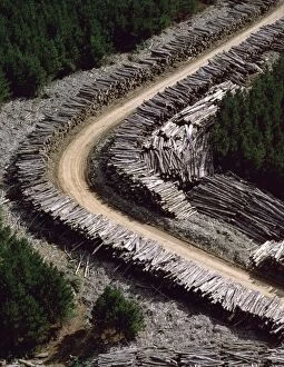
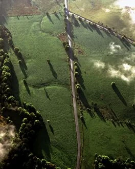
Aerial - Timber loading Northeastern Tasmania, Australia JPF49498JPF-13845 Aerial - Timber loading Northeastern Tasmania, Australia Jean-Paul Ferrero Please note that prints are for personal display purposes only and may not be reproduced in anyway
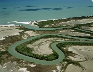
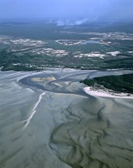
Aerial - Duck Creek - with ox-bows and mangrove-lined river banks, Gulf of Carpentaria, Cape York PeninsulaJPF-13862 Aerial - Duck Creek - with ox-bows and mangrove-lined river banks Gulf of Carpentaria, Cape York Peninsula, Queensland
Aerial - Cape York Peninsula - Gulf of Carpentaria - Mitchell River - MangrovesJPF-13864 Aerial - Cape York Peninsula - Gulf of Carpentaria Mitchell River - Mangroves and sand banks - Queensland - Australia Jean-Paul Ferrero Please note that prints are for personal display
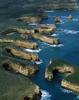
Aerial - Port Campbell National Park with Muttonbird Island in foreground, the Island ArchwayJPF-13825 Aerial - Port Campbell National Park with Muttonbird Island in foreground the Island Archway, and Twelve Apostles beyond, Victoria
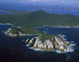
Aerial - Port Davey (northern shores) North Head - World Heritage Area, Southwest National ParkJPF-13836 Aerial - Port Davey (northern shores) North Head World Heritage Area, Southwest National Park, Tasmania (World Heritage Area)
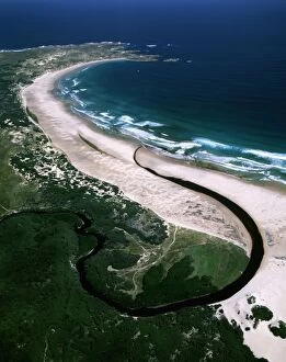
Aerial - Younghusband Peninsula Coorong National Park, South Australia, Shorebird Network Site; Ramsar wetland JPF49655JPF-13859 Aerial - Younghusband Peninsula Coorong National Park, South Australia Shorebird Network Site; Ramsar wetland Jean-Paul Ferrero Please note that prints are for personal display purposes
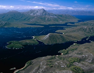
Aerial - Towterer Creek area & De Witt Range Southwest National Park, Tasmania (World Heritage Area)JPF-13843 Aerial - Towterer Creek area & De Witt Range Southwest National Park Tasmania (World Heritage Area), Australia Jean-Paul Ferrero Please note that prints are for personal display purposes
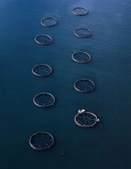
Aerial - Salmon farming off Port Arthur (aquaculture) Tasmania, Australia JPF49468JPF-13848 Aerial - Salmon farming off Port Arthur (aquaculture) Tasmania, Australia Jean-Paul Ferrero Please note that prints are for personal display purposes only
Boucaut Bay, aerial sandy beach & mangrove, bushfire in distance, Arnhemland, Northern Territory, Australia JPF48711JPF-13822 Boucaut Bay, aerial sandy beach & mangrove, bushfire in distance Arnhemland, Northern Territory, Australia Jean-Paul Ferrero Please note that prints are for personal display purposes only
Boucaut Bay, aerial sandy beach & mangroves, Arnhemland, Northern Territory, Australia JPF48714JPF-13820 Boucaut Bay, aerial sandy beach & mangroves Arnhemland, Northern Territory, Australia Jean-Paul Ferrero Please note that prints are for personal display purposes only
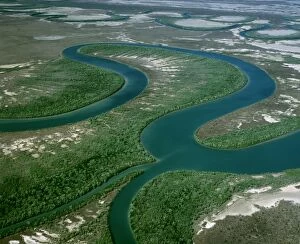
Gin Arm Creek aerial showing oxbows (meanders), Gulf of Carpentaria, Queensland, Australia JPF48727JPF-13818 Gin Arm Creek aerial showing oxbows (meanders) Gulf of Carpentaria, Queensland, Australia Jean-Paul Ferrero Please note that prints are for personal display purposes only
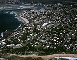
Aerial - Noosa: Heads, main beach & Sound Sunshine Coast, Queensland, Australia JPF48318JPF-13810 Aerial - Noosa: Heads, main beach & Sound Sunshine Coast, Queensland, Australia Jean-Paul Ferrero Please note that prints are for personal display purposes only
Caloundra aerial, Sunshine Coast, Queensland, Australia JPF48341JPF-13809 Caloundra aerial, Sunshine Coast Queensland, Australia Jean-Paul Ferrero Please note that prints are for personal display purposes only and may not be reproduced in anyway
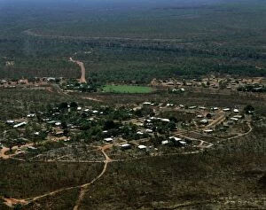
Aerial - Borroloola Northern Territory, Australia JPF48663JPF-13807 Aerial - Borroloola Northern Territory, Australia Jean-Paul Ferrero Please note that prints are for personal display purposes only and may not be reproduced in anyway
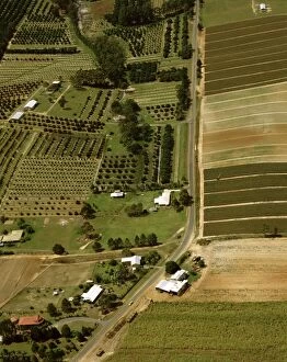
Pineapple & Macadamia plantations Sunshine Coast, Queensland, Australia JPF48685JPF-13806 Pineapple & Macadamia plantations Sunshine Coast Queensland, Australia Jean-Paul Ferrero Please note that prints are for personal display purposes only and may not be reproduced in anyway
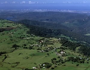
Aerial - Agricultural land & distant Gold Coast high-rises near Beechmont, Queensland JPF48697JPF-13805 Aerial - Agricultural land & distant Gold Coast high-rises near Beechmont, Queensland Jean-Paul Ferrero Please note that prints are for personal display purposes only
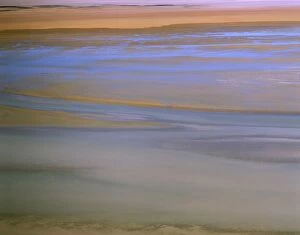
Aerial - Lake Eyre North filling up Lake Eyre National Park, South Australia JPF48134JPF-13801 Aerial - Lake Eyre North filling up Lake Eyre National Park, South Australia Jean-Paul Ferrero Please note that prints are for personal display purposes only
Aerial - Oxley River Valley farmland, between Mount Warning & the McPherson Range New South Wales, Australia JPF48233JPF-13795 Aerial - Oxley River Valley farmland, between Mount Warning & the McPherson Range New South Wales Australia Jean-Paul Ferrero Please note that prints are for personal display purposes only
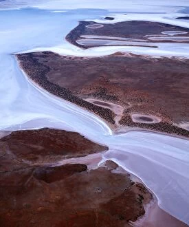
Aerial - Lake Gairdner, aerial About 160 kilometres long and 50 kilometres acrossJPF-13794 Aerial - Lake Gairdner, aerial About 160 kilometres long and 50 kilometres across with salt more than a metre thick at some points
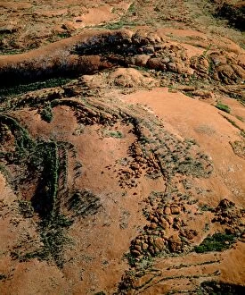
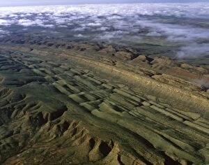
Aerial - Everard Ranges on the northern edge of the Great Victoria Desert, northern edge of Great Victoria DesertJPF-13793 Aerial - Everard Ranges on the northern edge of the Great Victoria Desert northern edge of Great Victoria Desert
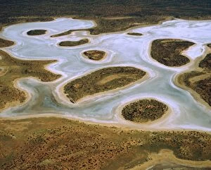
Aerial - Lake Amadeus salt lake, Kajiti Aboriginal Land, Northern Territory, Australia JPF47718JPF-13791 Aerial - Lake Amadeus salt lake Kajiti Aboriginal Land, Northern Territory, Australia Jean-Paul Ferrero Please note that prints are for personal display purposes only
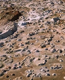
Aerial - Opal mining, aerial Coober Pedy, South Australia JPF47786JPF-13789 Aerial - Opal mining, aerial Coober Pedy South Australia Jean-Paul Ferrero Please note that prints are for personal display purposes only and may not be reproduced in anyway
Aerial - James Ranges (Ltalaltuma Aboriginal Land) Northern Territory, Australia JPF47798JPF-13788 Aerial - James Ranges (Ltalaltuma Aboriginal Land) Northern Territory, Australia Jean-Paul Ferrero Please note that prints are for personal display purposes only
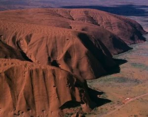
Aerial - Uluru (Ayers Rock), base, aerial Uluru-Kata Tjuta National Park (World Heritage Area), Northern TerritoryJPF-13786 Aerial - Uluru (Ayers Rock), base, aerial Uluru-Kata Tjuta National Park (World Heritage Area), Northern Territory