mail_outline sales@mediastorehouse.com
Rossing Mountain and the ancient Moon Valley landscape seen from the air - Natural drainages cut through the ancientKAT-714 Rossing Mountain and the ancient Moon Valley landscape seen from the air Natural drainages cut through the ancient rock below - Namib Desert - Namibia - Africa Karl Terblanche Please note
The Moon Valley from the air - landscape showing folded marbles gneisses and doerite dykes - from the 500 million yearKAT-720 The Moon Valley from the air - landscape showing folded marbles gneisses and doerite dykes - from the 500 million year metamorphism of the Damaran rocks Damaran orogeny - Namib Desert
Aerial view of mist rolling in from the cold Atlantic Ocean over the Namib Desert Plains - Namib Desert - NamibiaKAT-715 Aerial view of mist rolling in from the cold Atlantic Ocean over the Namib Desert Plains Namib Desert - Namibia - Africa Karl Terblanche Please note that prints are for personal display
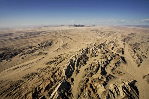
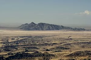
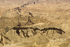
Rossing Mountain and the ancient Moon Valley landsurface - The area is a hotbed for uranium prospecting - NearKAT-703 Rossing Mountain and the ancient Moon Valley landsurface - The area is a hotbed for uranium prospecting Near Swakopmund - Namibia - Africa Karl Terblanche Please note that prints are for
Dolerite dyke controls natural erosion patterns in the Moon Valley - Namib Desert - Namibia - AfricaKAT-711 Dolerite dyke controls natural erosion patterns in the Moon Valley Namib Desert - Namibia - Africa Karl Terblanche Please note that prints are for personal display purposes only
Black dolerite dykes clearly visible as they cut through the rocky terrain of the Moon Valley near Swakopmund - NamibKAT-700 Black dolerite dykes clearly visible as they cut through the rocky terrain of the Moon Valley near Swakopmund Namib Desert - Namibia - Africa Karl Terblanche Please note that prints are for
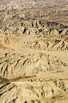
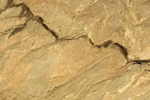
Marble dolerite and gneiss seen from the air - Moon Valley near Swakopmund - Namibia - AfricaKAT-701 Marble dolerite and gneiss seen from the air Moon Valley near Swakopmund - Namibia - Africa Karl Terblanche Please note that prints are for personal display purposes only
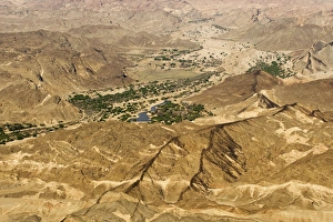
Black dolerite dykes spread through the Moon Valley Landscape - The Swakop River with its green foliage leads off intoKAT-699 Black dolerite dykes spread through the Moon Valley Landscape - The Swakop River with its green foliage leads off into the distance Namib Desert - Namibia - Africa Karl Terblanche Please note
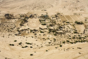
Uran development spreading into the desert - small holdings and an oval race track - Namib Desert - Namibia - AfricaKAT-708 Uran development spreading into the desert - small holdings and an oval race track Namib Desert - Namibia - Africa Karl Terblanche Please note that prints are for personal display purposes
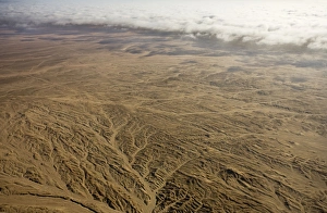
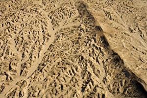
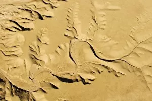
Drainage Patterns on the ancient Namib Plains - aerial view of the desert near Swakopmund - Namib Desert - NamibiaKAT-695 Drainage Patterns on the ancient Namib Plains - aerial view of the desert near Swakopmund Namib Desert - Namibia - Africa Karl Terblanche Please note that prints are for personal display
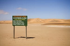
Conservation board at the begging of the Dune Sea - -Dune Fields - Namib Desert - Namibia - AfricaKAT-555 Conservation board at the begging of the Dune Sea Dune Fields - Namib Desert - Namibia - Africa Karl Terblanche Please note that prints are for personal display purposes only
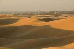
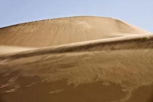
Swakopmund - scene from the dunes - Dune Fields - Namib Desert - Namibia - AfricaKAT-552 Swakopmund - scene from the dunes Dune Fields - Namib Desert - Namibia - Africa Karl Terblanche Please note that prints are for personal display purposes only
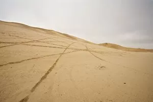
Vehicle tracks on the inter dunal gravel plains - destruction caused by quad bikes - Dune Fields - Namib DesertKAT-551 Vehicle tracks on the inter dunal gravel plains - destruction caused by quad bikes Dune Fields - Namib Desert - Namibia - Africa Karl Terblanche Please note that prints are for personal
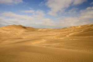
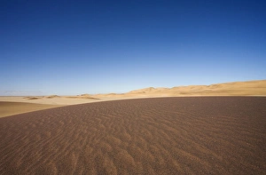
Dune scene - under a blue sky with light clouds - Dune Fields - Namib Desert - Namibia - AfricaKAT-547 Dune scene - under a blue sky with light clouds Dune Fields - Namib Desert - Namibia - Africa Karl Terblanche Please note that prints are for personal display purposes only
Water flowing over smooth rocks in the Naukluft Mountains - Namib Naukluft Park - Fringes of the Namib Desert - NamibiaKAT-694 Water flowing over smooth rocks in the Naukluft Mountains - Namib Naukluft Park Fringes of the Namib Desert - Namibia - Africa Karl Terblanche Please note that prints are for personal display
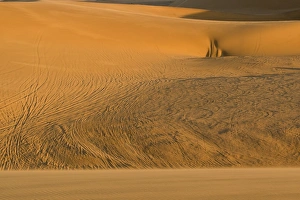
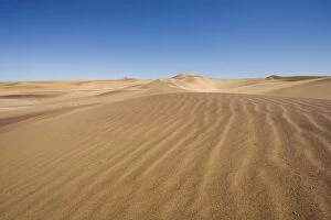
Sand blowing along the slipface of a dune - Dune Fields - Namib Desert - Namibia - AfricaKAT-529 Sand blowing along the slipface of a dune Dune Fields - Namib Desert - Namibia - Africa Karl Terblanche Please note that prints are for personal display purposes only
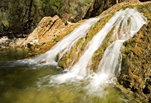
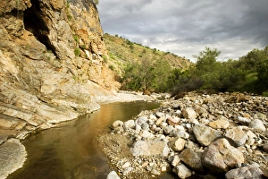
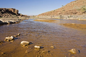
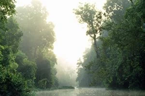
Water flowing over rocky terrain - Namib Desert - Namibia - AfricaKAT-689 Water flowing over rocky terrain Namib Desert - Namibia - Africa Karl Terblanche Please note that prints are for personal display purposes only and may not be reproduced in anyway
Water flows in the Naukluft Mountains under a stormy sky - Namib Naukluft Park - Fringes of the Namib Desert - NamibiaKAT-693 Water flows in the Naukluft Mountains under a stormy sky - Namib Naukluft Park Fringes of the Namib Desert - Namibia - Africa Karl Terblanche Please note that prints are for personal display
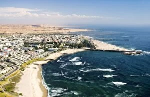
Town & shoreline - Namib Desert - Namibia - AfricaKAT-686 Town & shoreline Namib Desert - Namibia - Africa Karl Terblanche Please note that prints are for personal display purposes only and may not be reproduced in anyway
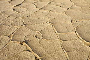
Cracked Caly in the Desert Namib Desert, Namibia, AfricaKAT-294 Cracked Clay in the Desert Namib Desert, Namibia, Africa Karl Terblanche Please note that prints are for personal display purposes only and may not be reproduced in anyway
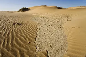
Cracked clay in the dunes Remnants of the sparse rainfall Namib Desert, Namibia, AfricaKAT-293 Cracked clay in the dunes - Remnants of the sparse rainfall Namib Desert, Namibia, Africa Karl Terblanche Please note that prints are for personal display purposes only
Vehicle tracks in the dunes Left by a 4x4 crossing the dune sea Namib Desert, Namibia, AfricaKAT-291 Vehicle tracks in the dunes - Left by a 4x4 crossing the dune sea Namib Desert, Namibia, Africa Karl Terblanche Please note that prints are for personal display purposes only
Darker dune Sand Contrasting with the Common Yellow dunes The colour is due to natural heavy metals found in the sandKAT-286 Darker dune Sand Contrasting with the Common Yellow dunes The colour is due to natural heavy metals found in the sand Namib Desert, Namibia
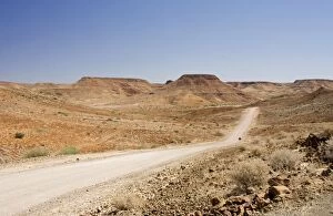
Gravel Roads winding through a rugged environment Near Vreede Damaraland, Namibia, AfricaKAT-284 Gravel Roads winding through a rugged environment Near Vreede, Damaraland, Namibia, Africa Karl Terblanche Please note that prints are for personal display purposes only
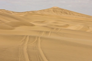
Tracks scar the dunes and Gravel Plains Left by scramblers Near Swakopmund, Namibia, AfricaKAT-280 Tracks scar the dunes and Gravel Plains - Left by scramblers Near Swakopmund, Namibia, Africa Tracks on the Gravel Plains will remain for more than 100 years
Dune Scene with blue sky Cetral Dune Belt near Swakopmund Namibia, AfricaKAT-278 Dune Scene with blue sky Central Dune Belt near Swakopmund - Namibia, Africa Karl Terblanche Please note that prints are for personal display purposes only
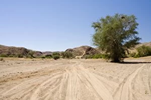
Vehicle tracks in a dry river bed Damaraland, Namibia, AfricaKAT-277 Vehicle tracks in a dry river bed Damaraland, Namibia, Africa Karl Terblanche Please note that prints are for personal display purposes only and may not be reproduced in anyway
Water in the Desert Precious water near Palmwag Damaraland, Namibia, AfricaKAT-276 Water in the Desert - Precious water near Palmwag Damaraland, Namibia, Africa Karl Terblanche Please note that prints are for personal display purposes only
The Kolmanskop Stranded On rocky reef near Swakopmund, warning notice Namibia, AfricaKAT-273 The Kolmanskop Stranded - On rocky reef near Swakopmund, warning notice Namibia, Africa Karl Terblanche Please note that prints are for personal display purposes only
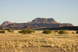
Typical view of a flat top mountain Of North Western Namibia Damaraland, Namibia, AfricaKAT-272 Typical view of a flat top mountain of North Western Namibia Damaraland, Namibia, Africa Karl Terblanche Please note that prints are for personal display purposes only
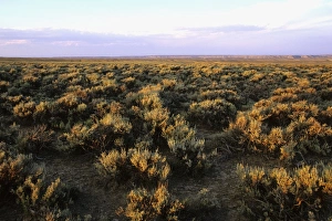
USA - Prairie in WyomingJZ-3052 USA - Prairie in Wyoming Jim Zipp Please note that prints are for personal display purposes only and may not be reproduced in anyway
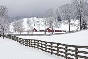
Farm in winter just after a snow. CT, USAJZ-2792 Farm in winter just after a snow. CT, USA Jim Zipp Please note that prints are for personal display purposes only and may not be reproduced in anyway
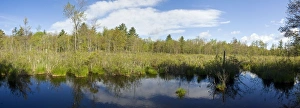
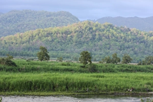
Freshwater Marsh in White Memorial Preserve. Litchfield CT USA - MayJZ-3216 Freshwater Marsh in White Memorial Preserve Litchfield CT USA - May Jim Zipp Please note that prints are for personal display purposes only and may not be reproduced in anyway
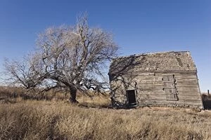
USA - Abandoned farmhouse Texas PanhandleJZ-2938 USA - Abandoned farmhouse Texas Panhandle Jim Zipp Please note that prints are for personal display purposes only and may not be reproduced in anyway
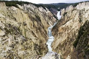
USA - Grand Canyon of the Yellowstone Yellowstone National ParkJZ-2165 USA - Grand Canyon of the Yellowstone Jim Zipp Please note that prints are for personal display purposes only and may not be reproduced in anyway
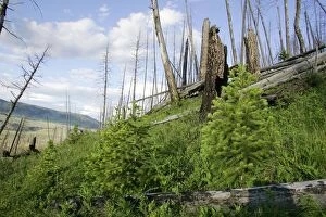
Yellowstone national park, 15 years after firesJZ-2161 Yellowstone national park, 15 years after fires USA Jim Zipp Please note that prints are for personal display purposes only and may not be reproduced in anyway
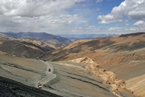
Trucks descending from Taglang La (5359m pass on Manali Leh road). Ladakh India North sideJVG-3573 Trucks descending from Taglang La (5359m pass on Manali Leh road) Ladakh India North side Joanna Van Gruisen Please note that prints are for personal display purposes only
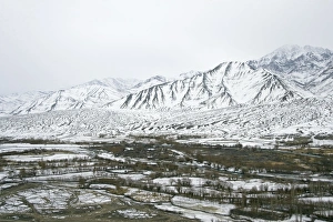
Indus Valley in Ladakh - winter scene. TransHimalaya IndiaJVG-3570 Indus Valley in Ladakh - winter scene TransHimalaya India Joanna Van Gruisen Please note that prints are for personal display purposes only and may not be reproduced in anyway
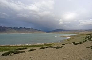
Tso Kar under cloud. Changthang, East Ladakh, IndiaJVG-3562 Tso Kar under cloud Changthang, East Ladakh, India Joanna Van Gruisen Please note that prints are for personal display purposes only and may not be reproduced in anyway
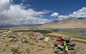
Prayer flags frame the twin lakes of the Tso Kar basin, Changthang, Ladakh, IndiaJVG-3555 Prayer flags frame the twin lakes of the Tso Kar basin Changthang, Ladakh, India Joanna Van Gruisen Please note that prints are for personal display purposes only
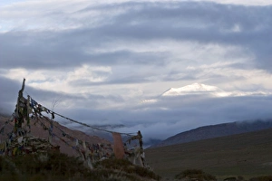
Prayer flags on a minor pass en route to Tso Kar basin, Changthang, Eastern Ladakh, India View towards Tanglang LaJVG-3550 Prayer flags on a minor pass en route to Tso Kar basin Changthang, Eastern Ladakh, India View towards Tanglang Joanna Van Gruisen Please note that prints are for personal display purposes
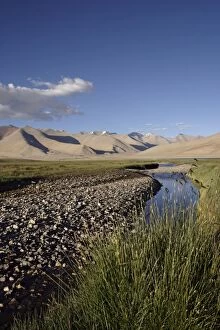
Tso Kar - Basin view - fresh water stream feeding into Startsapuk Tso, the fresh water twin lake of Tso Kar in the TsoJVG-3458 Tso Kar - Basin view - fresh water stream feeding into Startsapuk Tso, the fresh water twin lake of Tso Kar in the Tso Kar basin Trans Himalyan region of Eastern Ladakh at the beginning of
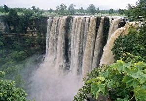
India - monsoon season. Tropical deciduous forest. Dhundwa falls, Panna National ParkJVG-3295 India - monsoon season. Tropical deciduous forest. Dhundwa falls, Panna National Park Joanna Van Gruisen Please note that prints are for personal display purposes only
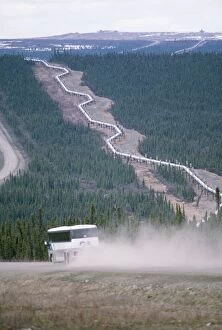
Oil Pipe Line AlaskaJS-692 Oil Pipe Line Alaska John Swedberg Please note that prints are for personal display purposes only and may not be reproduced in anyway
Corbett National Park, IndiaJR-1250 Corbett National Park, India Jagdeep Rajput Please note that prints are for personal display purposes only and may not be reproduced in anyway
Sabah - rainforest Borneo MalasiaJPF-8359 Sabah - rainforest Borneo Malaysia Jean Paul Ferrero Please note that prints are for personal display purposes only and may not be reproduced in anyway
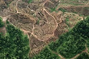
Borneo - Sabah - Oil palm plantations & remnant of rainforestJPF-9275 Borneo - Sabah - Oil palm plantations & remnant of rainfores Jean Paul Ferrero Please note that prints are for personal display purposes only and may not be reproduced in anyway
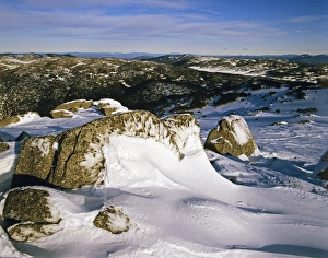
Granite boulders covered with wind-blown ice on Ramshead Range with Victoria beyond Kosciuszko National ParkJPF-14428 Granite boulders covered with wind-blown ice on Ramshead Range with Victoria beyond Kosciuszko National Park New South Wales