mail_outline sales@mediastorehouse.com
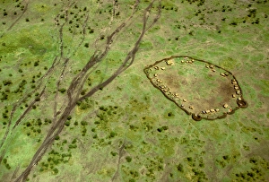
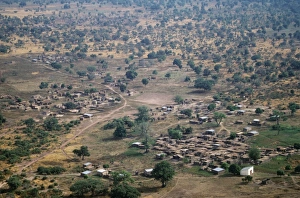
Aerial: Maasai village and vehicle tracks, Masai Mara, Kenya JFL14122FL-3273 Aerial: Maasai village and vehicle tracks Maasai Mara, Kenya Ferrero Labat Please note that prints are for personal display purposes only and may not be reproduced in anyway
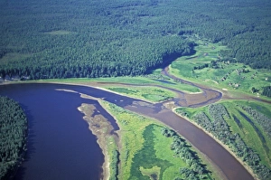
Siberian Taiga - Ural Mountains - SiberiaCAN-3546 Siberian Taiga Ural Mountains - Siberia John Cancalosi Please note that prints are for personal display purposes only and may not be reproduced in anyway
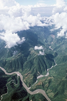
Nepal - Himalayas foothillsBMD-40 Nepal - Himalayas foothills Brian McDairmant Please note that prints are for personal display purposes only and may not be reproduced in anyway
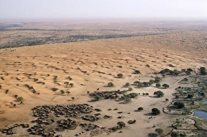
West Africa - village & sand dunes Burkina Faso is a landlocked nation in West AfricaBMD-106 West Africa - village & sand dunes Burkina Faso is a landlocked nation in West Africa. Brian McDairmant Please note that prints are for personal display purposes only
West Africa - village near Bobo Burkina Faso is a landlocked nation in West AfricaBMD-100 West Africa - village near Bobo Burkina Faso is a landlocked nation in West Africa. Brian McDairmant Please note that prints are for personal display purposes only
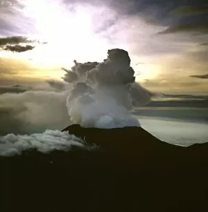
Aerial view of the Great Rift Valley, East Africa: Mount Nyiragongo, an active volcano in the Virunga Mountains inAW-6814 Aerial view of the Great Rift Valley, East Africa East Africa: Mount Nyiragongo, an active volcano in the Virunga Mountains in Virunga National Park
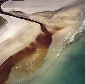
Aerial image of Scotland, UK: Sinclair's Bay, south of Keiss, north-east Caithness, east coast of ScotlandAW-6851 Aerial image of Scotland, UK: Sinclair's Bay south of Keiss, north-east Caithness, east coast of Scotland. Water of the Burn of Lyth flows through Loch of Wester
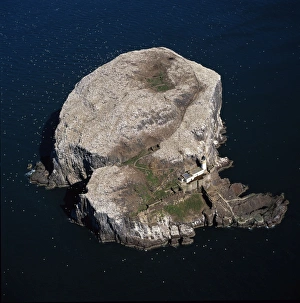
Aerial image of Scotland, UK: Bass Rock (The Bass), Volcanic plug of Phonolite in the Firth of Forth, near AuldhameAW-6841 Aerial image of Scotland, UK: Bass Rock (The Bass) Volcanic plug of Phonolite in the Firth of Forth, near Auldhame, East Lothian
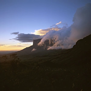
Mount Kukenaam (Kukenan, Kukenan, Cuguenan) from the upper slopes of Roraima, Gran Sabana, Estado Boliovar, VenezuelaAW-6719 Mount Kukenaam (Kukenan, Kukenan, Cuguenan) from the upper slopes of Roraima Gran Sabana, Estado Boliovar, Venezuela
Aerial image of Venezuela, South America: Skeleton forest (damaged from forest fire) on La Gran SabanaAW-6749 Aerial image of Venezuela, South America Skeleton forest (damaged from forest fire) on La Gran Sabana, Canaima National Park
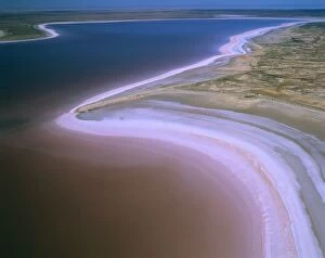
Lake Eyre North - dry salt lake that floods a few times each century and Jackboot BayAUS-1894 Lake Eyre North - dry salt lake that floods a few times each century and Jackboot Bay, along Hunt Peninsula (Elliot Price Conservation Park) fills with pink tinted water (algae)
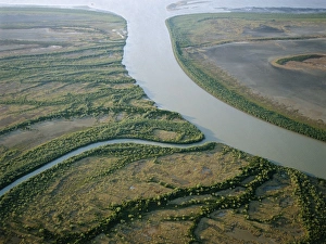
Australia Bynoe River floodplain, Gulf of Carpentaria, QueenslandAU-41-law AUSTRALIA - Coastal wetland wilderness of the Bynoe River floodplain near its mouth Gulf of Carpentaria, Queensland, Australia Showing tidal saltflats and mangrove lined channels
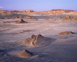
Chile - Valle De Le Luna (Valley of the Moon). Driest place on earth, Atacama Desert, Los Flamencos National ReserveAU-5-PLA Chile - Valle De Le Luna (Valley of the Moon). Driest place on earth, Atacama Desert, Los Flamencos National Reserve Auscape Please note that prints are for personal display purposes only
Arctic tundra - aerial view from a helicopter. A typical landscape near Kara sea, Taimyr peninsula, North of SiberiaANZ-996 Arctic tundra - aerial view from a helicopter. landscape near Kara sea, Taimyr peninsula, North of Siberia, Russian Arctic. Summer, July
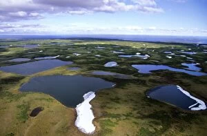
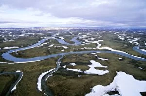
Semi-tundra, aerial view from a helicopter. A typical landscape near large lake Pyasina, Taimyr peninsulaANZ-993 Semi-tundra, aerial view from a helicopter. landscape near large lake Pyasina, Taimyr peninsula, North of Siberia, Russian Arctic, summer
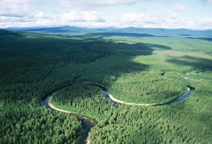
Russia Aerial. Coniferous boreal forest. Taiga Forest & river, North Ural MountainsANZ-683 RUSSIA - North Urals Mountains, Aerial, view Taiga Forest, Ural mountains, Russia Andrey Zvoznikov Please note that prints are for personal display purposes only
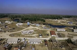
Maloyuganskii village, aerial view over the village and taiga-forest, a fog visible over horizon due to uncontrolledANZ-788 Maloyuganskii village - aerial of village and taiga forest near Surgut, Siberia, Russia. Spring Fog visible on the horizon is due to smoke from uncontrolled forest fires
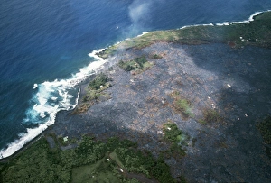
Hawaii - Kalapana gardens destroyed by lavaFG-5714 Hawaii - Kalapana gardens destroyed by lava from volcano Francois Gohier Please note that prints are for personal display purposes only and may not be reproduced in anyway
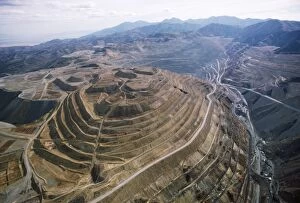
Copper Mine - Kennecott open pit, largest in Northern America. Utah, USAFG-4240 COPPER Mine - Kennecott open pit, largest in Northern America Utah, USA Francois Gohier Please note that prints are for personal display purposes only and may not be reproduced in anyway
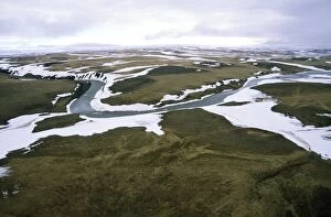
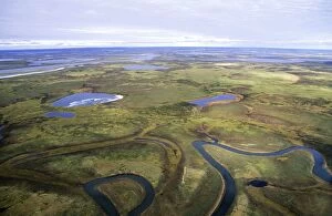
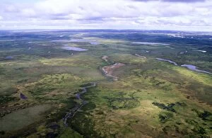
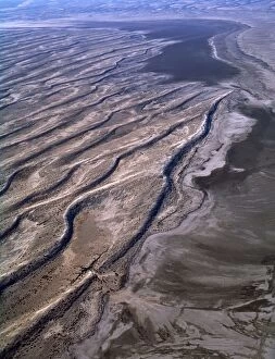
Tundra - lakes and rivers - an aerial view from a helicopter. A smaller river has an old river-bed, on foregroundANZ-1298 Tundra - lakes and rivers - an aerial view from a helicopter. A smaller river has an old river-bed, on foreground
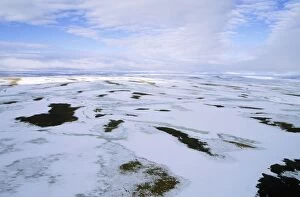
Snow melts in arctic tundra spring. Aerial view from a helicopter. A typical landscape near Kara sea, Taimyr peninsulaANZ-1305 Snow melts in arctic tundra spring. Aerial view from a helicopter. landscape near Kara sea, Taimyr peninsula, North of Siberia, Russian Arctic. July
Tundra - aerial view from a helicopter. A typical landscape in Taimyr peninsula, North of Siberia, Russian ArcticANZ-1297 Tundra - aerial view from a helicopter. Taimyr peninsula, North of Siberia, Russian Arctic, summer Andrey Zvoznikov Please note that prints are for personal display purposes only
Arctic tundra in spring - an aerial view from a helicopter. A typical landscape near Kara sea, Taimyr peninsulaANZ-1310 Arctic tundra in spring - an aerial view from a helicopter. landscape near Kara sea, Taimyr peninsula, North of Siberia, Russian Arctic. Summer, July
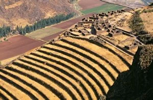
Peru - Pisac: agricultural terrasses Inca Cusco RegionFG-10823 Peru - Pisac: agricultural terrasses Inca Cusco Region Francois Gohier Please note that prints are for personal display purposes only and may not be reproduced in anyway
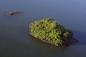
An island covered with rainforest vegetation in Sulu Sea near Sandakan; helicopter view; Sabah, BorneoANZ-1046 An island covered with rainforest vegetation in Sulu Sea near Sandakan Sabah, Borneo, Malaysia; morning in June. Andrey Zvoznikov Please note that prints are for personal display purposes
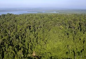
Rainforest and Sekong Bay near Sandakan; helicopter view; Sabah, Borneo, Malaysia; morning in June. Ma39. 3094ANZ-1047 Rainforest and Sekong Bay near Sandakan Sabah, Borneo, Malaysia; morning in June. Andrey Zvoznikov Please note that prints are for personal display purposes only
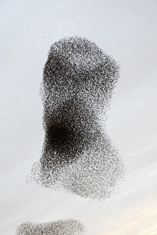
Starling FlockROY-488 Common Starling Flock - Large flock formation as the birds prepare to roost Gretna - Scotland Sturnus vulgaris Roy Glen Please note that prints are for personal display purposes only
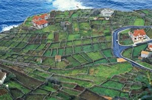
Madeira ROG 9526 Tiny fields hedged with Tree Heather, against wind. Port do Moniz, West MadiraROG-9526 Madeira - Tiny fields hedged with tree heather Port do Moniz, W. Madeira Bob Gibbons Please note that prints are for personal display purposes only and may not be reproduced in any way
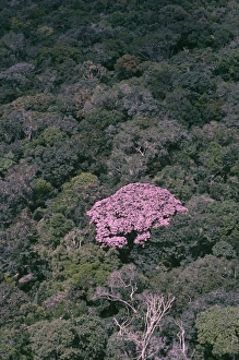
Rainforest - flowering couratari crown emergent rainforest tree, showing how tree uses colour to advertise forNG-1069 Rainforest - flowering couratari crown emergent rainforest tree, showing how tree uses colour to advertise for pollinators. Amazonia, Brazil
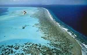
Maldives - atolls & coral reefs. Indian OceanKA-445 Maldives - atolls & coral platform reefs. Indian Ocean Kurt Amsler Please note that prints are for personal display purposes only and may not be reproduced in any way
Great Barrier Reef - hardy reef seperated from hook reef by deep channel Great Barrier Reef Marine Park, QueenslandJPF-9523 Great Barrier Reef - hardy reef seperated from hook reef by deep channel Great Barrier Reef Marine Park, Queensland, Australia
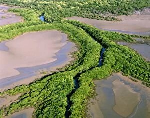
North Kennedy River - Mangrove-lined banks - Lakefield National Park, far north Queensland, Australia JPF52329JPF-14398 North Kennedy River - Mangrove-lined banks Lakefield National Park, far north Queensland, Australia Jean-Paul Ferrero Please note that prints are for personal display purposes only
Aerial - Port Davey (southern shores), Stephens Bay, Hannant Inlet, and Mount Rugby beyond JPF49253 Southwest NationalJPF-14385 Aerial - Port Davey (southern shores), Stephens Bay, Hannant Inlet, and Mount Rugby beyond Southwest National Park, Tasmania (World Heritage Area)
Aerial - Sand dunes near Warburton river mouth Lake Eyre National Park, South Australia JPF43143JPF-14339 Aerial - Sand dunes near Warburton river mouth Lake Eyre National Park, South Australia Jean-Paul Ferrero Please note that prints are for personal display purposes only
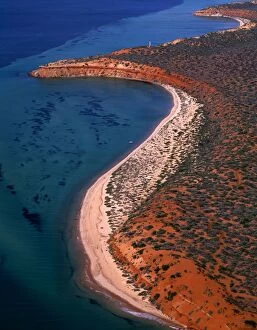
Aerial - Seagrass bed / dugong habitat at Cape Peron and Herald Bight Francois Peron National ParkJPF-14335 Aerial - Seagrass bed / dugong habitat at Cape Peron and Herald Bight Francois Peron National Park, Shark Bay Marine Park
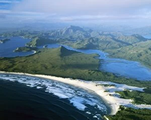
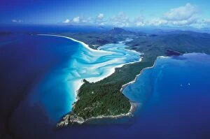
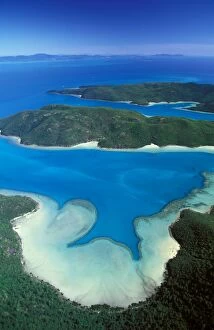
Aerial - Tongue Point, Hill Inlet, Whitehaven Beach Whitsunday Group, Great Barrier Reef Marine ParkJPF-14303 Aerial - Tongue Point, Hill Inlet, Whitehaven Beach Whitsunday Group, Great Barrier Reef Marine Park (World Heritage Area), Queensland
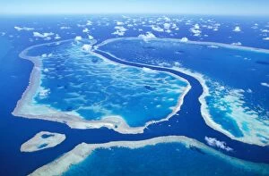
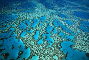
Aerial - Coral formation - Hardy Reef, Great Barrier Reef Marine Park (World Heritage Area), QueenslandJPF-14300 Aerial - Coral formation Hardy Reef, Great Barrier Reef Marine Park (World Heritage Area), Queensland, Australia Jean-Paul Ferrero Please note that prints are for personal display purposes
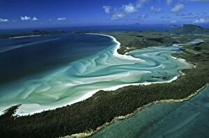
Aerial - Tongue Point, Hill Inlet and Whitehaven Beach Whitsunday Group, Great Barrier Reef Marine ParkJPF-14298 Aerial - Tongue Point, Hill Inlet and Whitehaven Beach Whitsunday Group, Great Barrier Reef Marine Park (World Heritage Area), Queensland
Aerial - Hook Island: Macona & Nara Inlets Whitsunday Group, Great Barrier Reef Marine Park (World Heritage Area)JPF-14297 Aerial - Hook Island: Macona & Nara Inlets Whitsunday Group, Great Barrier Reef Marine Park (World Heritage Area), Queensland
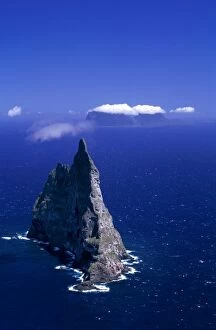
Aerial - Balls Pyramid world's tallest sea stack, 562 metres, Lord Howe Island, New South Wales, Australia JPF33533JPF-14289 Aerial - Balls Pyramid worlds tallest sea stack, 562 metres Lord Howe Island, New South Wales, Australia Jean-Paul Ferrero Please note that prints are for personal display purposes only
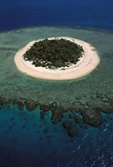
Aerial - Malamala Island - a coral cay - Mamanuca Group, Fiji JPF31628JPF-14276 Aerial - Malamala Island - a coral cay - Mamanuca Group, Fiji Jean-Paul Ferrero Please note that prints are for personal display purposes only and may not be reproduced in any way
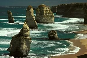
The Twelve Apostles - stack in foreground collapsed in 2005 Port Campbell National Park, Victoria, Australia JPF01559JPF-14065 The Twelve Apostles - stack in foreground collapsed in 2005 Port Campbell National Park, Victoria, Australia Jean-Paul Ferrero Please note that prints are for personal display purposes only
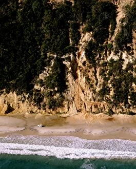
Aerial - Four-wheel driving beneath sand cliffs Cooloolah Section, Great Sandy National Park, QueenslandJPF-13993 Aerial - Four-wheel driving beneath sand cliffs Cooloolah Section, Great Sandy National Park, Queensland, Australia Jean-Paul Ferrero Please note that prints are for personal display
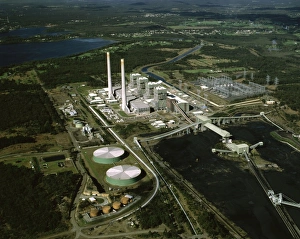
Coal-fired Eraring Power Station aerial shot. It provides about a quarter of the State's power needsJPF-13985 Coal-fired Eraring Power Station aerial shot. It provides about a quarter of the States power needs Southern end of Lake Macquarie, New South Wales
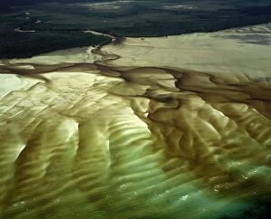
Aerial - A bay with shallow water revealing patterns in the white sand, Cape Grenville (not far from Shelburne Bay)JPF-13975 Aerial - A bay with shallow water revealing patterns in the white sand, Cape Grenville (not far from Shelburne Bay), Cape York Peninsula, Queensland
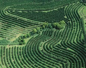
Aerial - Macadamia plantation Sunshine Coast, Queensland, Australia JPF52280JPF-13957 Aerial - Macadamia nut plantation Sunshine Coast Queensland, Australia Jean-Paul Ferrero Please note that prints are for personal display purposes only and may not be reproduced in any way
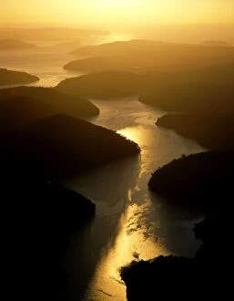
Cowan Water joining Hawkesbury River, with Broken Bay and Lion Island in background at sunriseJPF-13917 Cowan Water joining Hawkesbury River, with Broken Bay and Lion Island in background at sunrise Ku-ring-gai Chase National Park, Sydney, New South Wales
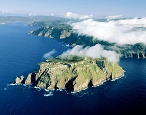
Aerial - Tasman Island and Cape Pillar with Tasman Island Lighthouse, Tasman National Park, Tasman Peninsula, TasmaniaJPF-13855 Aerial - Tasman Island and Cape Pillar with Tasman Island Lighthouse Tasman National Park, Tasman Peninsula, Tasmania