mail_outline sales@mediastorehouse.com
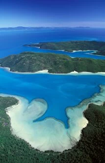
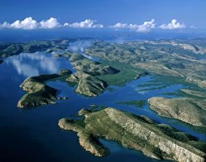
Aerial - Hook Island: Macona & Nara Inlets Whitsunday Group, Great Barrier Reef Marine Park (World Heritage Area)JPF-14297 Aerial - Hook Island: Macona & Nara Inlets Whitsunday Group, Great Barrier Reef Marine Park (World Heritage Area), Queensland
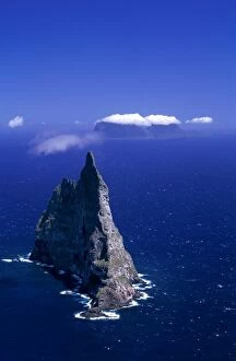
Aerial - Balls Pyramid world's tallest sea stack, 562 metres, Lord Howe Island, New South Wales, Australia JPF33533JPF-14289 Aerial - Balls Pyramid worlds tallest sea stack, 562 metres Lord Howe Island, New South Wales, Australia Jean-Paul Ferrero Please note that prints are for personal display purposes only
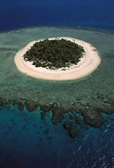
Aerial - Malamala Island - a coral cay - Mamanuca Group, Fiji JPF31628JPF-14276 Aerial - Malamala Island - a coral cay - Mamanuca Group, Fiji Jean-Paul Ferrero Please note that prints are for personal display purposes only and may not be reproduced in any way
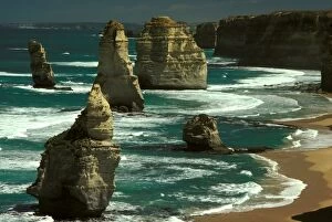
The Twelve Apostles - stack in foreground collapsed in 2005 Port Campbell National Park, Victoria, Australia JPF01559JPF-14065 The Twelve Apostles - stack in foreground collapsed in 2005 Port Campbell National Park, Victoria, Australia Jean-Paul Ferrero Please note that prints are for personal display purposes only
Aerial - Four-wheel driving beneath sand cliffs Cooloolah Section, Great Sandy National Park, QueenslandJPF-13993 Aerial - Four-wheel driving beneath sand cliffs Cooloolah Section, Great Sandy National Park, Queensland, Australia Jean-Paul Ferrero Please note that prints are for personal display
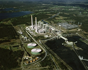
Coal-fired Eraring Power Station aerial shot. It provides about a quarter of the State's power needsJPF-13985 Coal-fired Eraring Power Station aerial shot. It provides about a quarter of the States power needs Southern end of Lake Macquarie, New South Wales
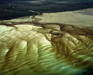
Aerial - A bay with shallow water revealing patterns in the white sand, Cape Grenville (not far from Shelburne Bay)JPF-13975 Aerial - A bay with shallow water revealing patterns in the white sand, Cape Grenville (not far from Shelburne Bay), Cape York Peninsula, Queensland
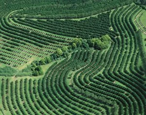
Aerial - Macadamia plantation Sunshine Coast, Queensland, Australia JPF52280JPF-13957 Aerial - Macadamia nut plantation Sunshine Coast Queensland, Australia Jean-Paul Ferrero Please note that prints are for personal display purposes only and may not be reproduced in any way
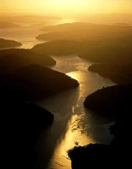
Cowan Water joining Hawkesbury River, with Broken Bay and Lion Island in background at sunriseJPF-13917 Cowan Water joining Hawkesbury River, with Broken Bay and Lion Island in background at sunrise Ku-ring-gai Chase National Park, Sydney, New South Wales
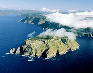
Aerial - Tasman Island and Cape Pillar with Tasman Island Lighthouse, Tasman National Park, Tasman Peninsula, TasmaniaJPF-13855 Aerial - Tasman Island and Cape Pillar with Tasman Island Lighthouse Tasman National Park, Tasman Peninsula, Tasmania
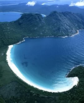
Aerial - Wineglass Bay and the Hazards Freycinet National Park, Tasmania, Australia JPF49185JPF-13837 Aerial - Wineglass Bay and the Hazards Freycinet National Park, Tasmania, Australia Jean-Paul Ferrero Please note that prints are for personal display purposes only
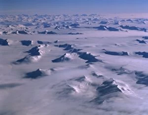
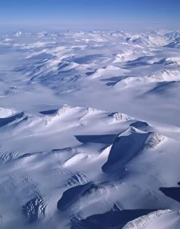
Aerial - Admiralty Mountains - Transanctartic Mountains - Antarctica JPF48805JPF-13834 Aerial - Admiralty Mountains Transanctartic Mountains - Antarctica Jean-Paul Ferrero Please note that prints are for personal display purposes only and may not be reproduced in any way
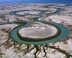
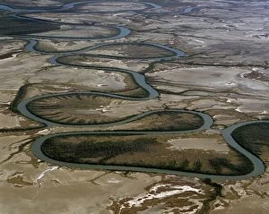
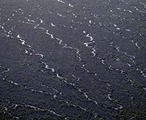
Aerial - Gin Arm Creek, oxbows (meanders) Gulf of Carpentaria, Queensland, Australia JPF48719JPF-13819 Aerial - Gin Arm Creek, oxbows (meanders) Gulf of Carpentaria, Queensland, Australia Jean-Paul Ferrero Please note that prints are for personal display purposes only
Wearyan River region aerial showing mangrove-lined banks, Gulf of Carpentaria, Northern Territory, Australia JPF48737JPF-13817 Wearyan River region aerial showing mangrove-lined banks Gulf of Carpentaria, Northern Territory, Australia Jean-Paul Ferrero Please note that prints are for personal display purposes only
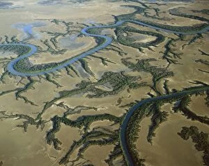
Aerial - McArthur River near delta, Gulf of Carpentaria, Northern Territory, Australia JPF48751JPF-13816 Aerial - McArthur River near delta, Gulf of Carpentaria, Northern Territory, Australia Jean-Paul Ferrero Please note that prints are for personal display purposes only
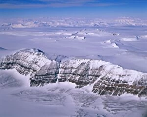
Aerial - Transactartic Mountains, Admiralty Mountains Victoria Land, Antarctica JPF48800JPF-13815 Aerial - Transactartic Mountains Admiralty Mountains Victoria Land, Antarctica Jean-Paul Ferrero Please note that prints are for personal display purposes only
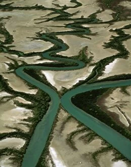
Aerial - Limmen Bight River, near the mouth with mangrove lined shores, Gulf of Carpentaria, Northern TerritoryJPF-13814 Aerial - Limmen Bight River, near the mouth with mangrove lined shores Gulf of Carpentaria, Northern Territory, Australia Jean-Paul Ferrero Please note that prints are for personal display
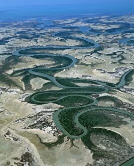
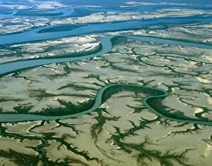
Aerial - Roper River delta Gulf of Carpentaria, Northern Territory, Australia JPF48298JPF-13813 Aerial - Roper River delta Gulf of Carpentaria Northern Territory, Australia Jean-Paul Ferrero Please note that prints are for personal display purposes only
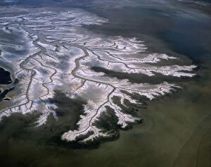
Aerial - Roper River delta aerial with saline flats and mangrove lined dendritic channels, Gulf of CarpentariaJPF-13808 Aerial - Roper River delta aerial with saline flats and mangrove lined dendritic channels Gulf of Carpentaria, Northern Territory
Aerial - Duck Creek oxbows Gulf of Carpentaria, Queensland, Australia JPF48259JPF-13796 Aerial - Duck Creek oxbows Gulf of Carpentaria Queensland, Australia Jean-Paul Ferrero Please note that prints are for personal display purposes only and may not be reproduced in any way
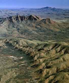
Aerial - Mounts Sonder & Ziel West MacDonnell National Park, Northern Territory, Australia JPF47825JPF-13787 Aerial - Mounts Sonder & Ziel West MacDonnell National Park Northern Territory, Australia Jean-Paul Ferrero Please note that prints are for personal display purposes only
Aerial - TransAntarctic Mountains Victoria Land, Antarctica JPF47231JPF-13779 Aerial - TransAntarctic Mountains Victoria Land Antarctica Jean-Paul Ferrero Please note that prints are for personal display purposes only and may not be reproduced in any way
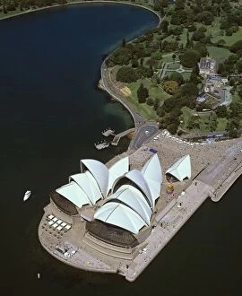
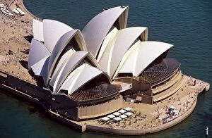
Aerial - Sydney Opera House - Sydney Australia JPF46730JPF-13737 Aerial - Sydney Opera House Sydney Australia Jean-Paul Ferrero Please note that prints are for personal display purposes only and may not be reproduced in any way
Sydney Opera House from the air Sydney, New South Wales, Australia JPF46840JPF-13736 Sydney Opera House from the air Sydney, New South Wales, Australia Jean-Paul Ferrero Please note that prints are for personal display purposes only and may not be reproduced in any way
Aerial - L. Eyre South: unnamed islands surrounded by rising water Lake Eyre National Park, South Australia JPF46549JPF-13730 Aerial - Lake Eyre South: unnamed islands surrounded by rising water Lake Eyre National Park, South Australia Jean-Paul Ferrero Please note that prints are for personal display purposes
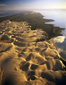
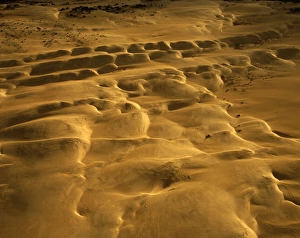
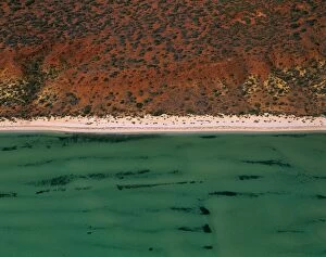
Bellefin Prong aerial showing sand dunes, Shark Bay Marine Park, Western Australia JPF44927JPF-13681 Bellefin Prong aerial showing sand dunes, Shark Bay Marine Park, Western Australia Jean-Paul Ferrero Please note that prints are for personal display purposes only
Aerial - Tidal flats along King Sound area, near Derby with mangrove-lined tidal riverJPF-13676 Aerial - Tidal flats along King Sound area, near Derby with mangrove-lined tidal river and dendritic drainage channels Kimberley region
Aerial: Talbot Bay Islands Kimberley region - coastal, Western Australia JPF44673JPF-13668 Aerial: Talbot Bay Islands Kimberley region coastal, Western Australia Jean-Paul Ferrero Please note that prints are for personal display purposes only and may not be reproduced in any way
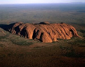
Aerial - Uluru (Ayers Rock) Aerial, Uluru-Kata Tjuta National Park (World Heritage Area), Northern TerritoryJPF-13635 Aerial - Uluru (Ayers Rock) Aerial, Uluru-Kata Tjuta National Park (World Heritage Area), Northern Territory, Australia Jean-Paul Ferrero Please note that prints are for personal display
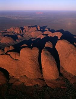
Aerial - Kata Tjuta (the Olgas) at sunset Uluru-Kata Tjuta National Park (World Heritage Area), Northern TerritoryJPF-13634 Aerial - Kata Tjuta (the Olgas) at sunset Uluru-Kata Tjuta National Park (World Heritage Area), Northern Territory
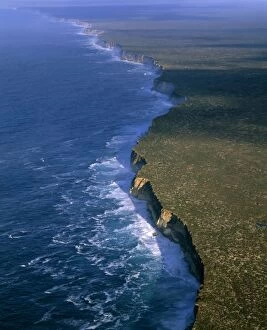
Aerial - Baxter Cliffs at edge of Nullarbor Plain/Great Australian Bight, Nuytsland Nature ReserveJPF-13632 Aerial - Baxter Cliffs at edge of Nullarbor Plain / Great Australian Bight Nuytsland Nature Reserve, Western Australia Jean-Paul Ferrero Please note that prints are for personal display
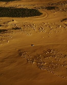
Aerial: ‘The Pinnacles Desert Nambung National Park, Western Australia JPF43806JPF-13617 Aerial: The Pinnacles Desert Nambung National Par Western Australia Jean-Paul Ferrero Please note that prints are for personal display purposes only and may not be reproduced in any way
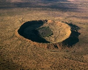
Wolfe Creek meteor crater, aerial second largest meteorite crater in Australia and about 25 million years oldJPF-13604 Wolfe Creek meteor crater Wolfe Creek Crater National Park, Kimberley region, Western Australia aerial second largest meteorite crater in Australia and about 25 million years old
Seagrass bed / dugong habitat at Herald Bight (Dugong dugon) Shark Bay, Peron Peninsula, Western Australia JPF43590JPF-13600 Seagrass bed / dugong habitat at Herald Bight (Dugong dugon) Shark Bay, Peron Peninsula, Western Australia Jean-Paul Ferrero Please note that prints are for personal display purposes only
Aerial: ‘The Pinnacles limestone pillars formed underground by vertical seepage, and cemented by dissolved limeJPF-13598 Aerial: The Pinnacles Nambung National Park, Western Australia limestone pillars formed underground by vertical seepage, and cemented by dissolved lime
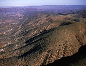
South Flinders Ranges South Australia JPF42884JPF-13585 South Flinders Ranges South Australia Jean-Paul Ferrero Please note that prints are for personal display purposes only and may not be reproduced in any way
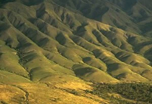
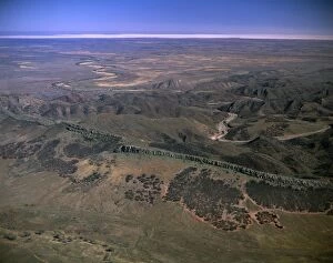
Aerial - North Flinders Ranges South Australia JPF43094JPF-13579 Aerial - North Flinders Ranges South Australia Jean-Paul Ferrero Please note that prints are for personal display purposes only and may not be reproduced in any way
Aerial - South Flinders Ranges near Hawker with salt lake in the far distance, South Australia JPF43139JPF-13578 Aerial - South Flinders Ranges near Hawker with salt lake in the far distance South Australia Jean-Paul Ferrero Please note that prints are for personal display purposes only
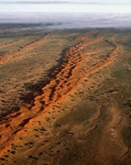
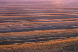
Longitudinal sand dunes aerial, Strzelecki Desert, South Australia JPF41247JPF-13564 Longitudinal sand dunes aerial Strzelecki Desert, South Australia Jean-Paul Ferrero Please note that prints are for personal display purposes only and may not be reproduced in any way
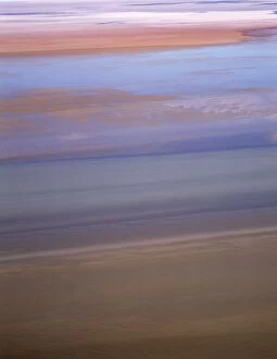
Goyder Lagoon Simpson Desert, South Australia JPF41557JPF-13561 Goyder Lagoon Simpson Desert South Australia Jean-Paul Ferrero Please note that prints are for personal display purposes only and may not be reproduced in any way
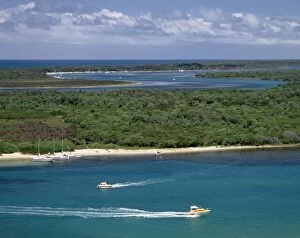
Aerial: Lakes Entrance Victoria with boats - Australia JPF41568JPF-13560 Aerial: Lakes Entrance Victoria with boats Australia Jean-Paul Ferrero Please note that prints are for personal display purposes only and may not be reproduced in any way
Dunefields, Longitudinal sand dunes S. E. Simpson Desert, South Australia JPF41712JPF-13559 Dunefields Longitudinal sand dunes S.E. Simpson Desert, South Australia Jean-Paul Ferrero Please note that prints are for personal display purposes only
Lake Eyre North filling up, Lake Eyre National Park, South Australia JPF41417JPF-13555 Lake Eyre North filling up Lake Eyre National Park, South Australia Jean-Paul Ferrero Please note that prints are for personal display purposes only and may not be reproduced in any way
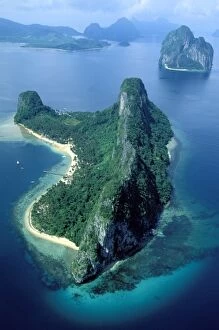
Bacuit Bay - near El Nido, Malapacao Island, Palawan, Philippines JPF37947JPF-13468 Bacuit Bay - near El Nido Malapacao Island, Palawan, Philippines Jean-Paul Ferrero Please note that prints are for personal display purposes only and may not be reproduced in any way
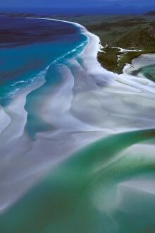
Hill Inlet, Whitehaven Beach Great Barrier Reef Marine Park (World Heritage Area), Queensland, Australia JPF34527JPF-13400 Hill Inlet, Whitehaven Beach Great Barrier Reef Marine Park (World Heritage Area), Queensland, Australia Jean-Paul Ferrero Please note that prints are for personal display purposes only
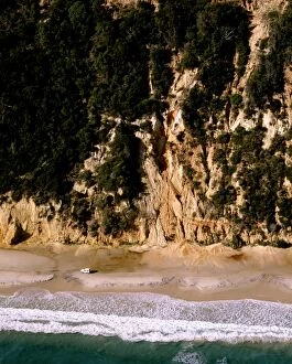
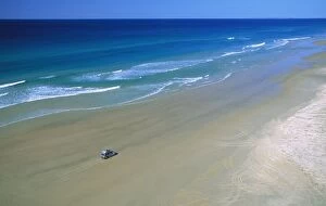
Seventy-five Mile Beach with 4WD vehicle; aerial, Fraser Island, Queensland, Australia JPF34617JPF-13397 Seventy-five Mile Beach with 4WD vehicle aerial, Fraser Island, Queensland, Australia Jean-Paul Ferrero Please note that prints are for personal display purposes only
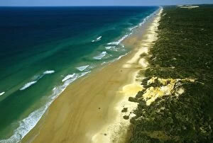
Seventy-five Mile Beach aerial, Great Sandy National Park, Fraser Island, Queensland, Australia JPF34624JPF-13396 Seventy-five Mile Beach aerial Great Sandy National Park, Fraser Island, Queensland, Australia Jean-Paul Ferrero Please note that prints are for personal display purposes only
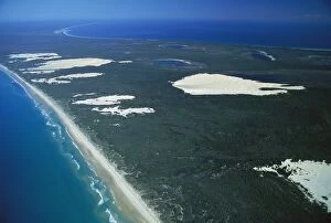
Aerial, lagoons lakes, sand dunes Great Sandy National Park, Fraser Island, Queensland, Australia JPF34643JPF-13395 Aerial, lagoons lakes, sand dunes Great Sandy National Park Fraser Island, Queensland, Australia Jean-Paul Ferrero Please note that prints are for personal display purposes only