mail_outline sales@mediastorehouse.com
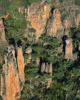
Australia - sandstone kombolgie formation (early Proterozoic 1700 Ma) Mt Brockman area 9detached part of the ArnhemJPF-12429 Australia - sandstone kombolgie formation (early Proterozoic 1700 Ma) Mt Brockman area 9 detached part of the Arnhem Land Plateau / Escarpment) Kakadu National Park
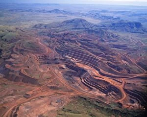
Australia - mining iron ore-open cut mine. Pilbara region, Hamersley RangeJPF-11728 Australia - mining iron ore-open cut mine. Pilbara region, Hamersley Range Jean Paul Ferrero Please note that prints are for personal display purposes only
Western Australia - The Pinnacles aerial view. Limestone pillars formed underground by vertical seepageJPF-11735 Western Australia - The Pinnacles aerial view. Nambung National Park, Western Australia. Limestone pillars formed underground by vertical seepage. Dissolved lime cemented
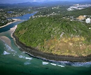
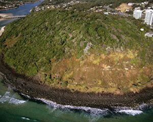
Basalt hill Burleigh Head National Park, Tallebudgera Creek near Southport, Gold Coast, Queensland, Australia JLR06983JLR-348 Basalt hill Burleigh Head National Park, Tallebudgera Creek near Southport, Gold Coast, Queensland, Australia Jean-marc La Roque Please note that prints are for personal display purposes only
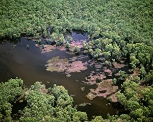
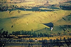
Aerial - Murray River and billabong - near Wentworth, New South Wales, Australia, JLR06370JLR-228 Aerial - Murray River and billabong near Wentworth, New South Wales, Australia Jean-marc La Roque Please note that prints are for personal display purposes only
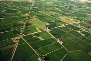
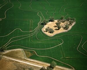
Aerial - Citrus and apricot orchards - Murray River irrigation area Mildura, Victoria, Australia JLR06622JLR-367 Aerial - Citrus and apricot orchards Murray River irrigation area Mildura, Victoria, Australia Jean-marc La Roque Please note that prints are for personal display purposes only
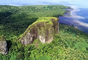
Aerial - Volcanic formation Pohnpei, Micronesia JLR04333JLR-325 Aerial - Volcanic formation Pohnpei Micronesia Jean-marc La Roque Please note that prints are for personal display purposes only and may not be reproduced in anyway
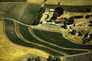
Aerial - Vineyards on edge of Barossa Valley, from the air South Australia JLR06678JLR-364 Aerial - Vineyards on edge of Barossa Valley from the air South Australia Jean-marc La Roque Please note that prints are for personal display purposes only
Aerial - Ricefield - Barham, New South Wales, Australia JLR06357JLR-328 Aerial - Ricefield - Barham New South Wales, Australia Jean-marc La Roque Please note that prints are for personal display purposes only and may not be reproduced in anyway
Aerial - Basalt hill - Burleigh Head National Park, Tallebudgera Creek near Southport, Gold Coast, QueenslandJLR-387 Aerial - Basalt hill - Burleigh Head National Park, Tallebudgera Creek near Southport, Gold Coast, Queensland, Australia Jean-marc La Roque Please note that prints are for personal display
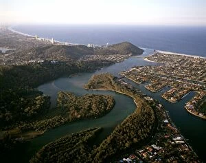
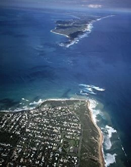
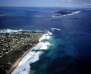
Gold Coast with Burleigh Head & Burleigh Head National Park Queensland, Australia JLR06978JLR-350 Gold Coast with Burleigh Head & Burleigh Head National Park Queensland, Australia Jean-marc La Roque Please note that prints are for personal display purposes only
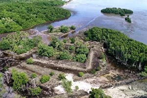
Aerial - Nan Douwas, walls 8 metres high of basalt columns Nan Madol fortress (c. 1200 AD) Pohnpei, Micronesia JLR04336JLR-323 Aerial - Nan Douwas, walls 8 metres high of basalt columns Nan Madol fortress (c.1200 AD) Pohnpei, Micronesia Jean-marc La Roque Please note that prints are for personal display purposes only
Hume Highway Victoria, Australia JLR02350JLR-289 Hume Highway Victoria, Australia Jean-marc La Roque Please note that prints are for personal display purposes only and may not be reproduced in anyway
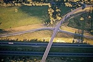
Aerial - Hume Highway - Victoria, Australia JLR02346JLR-250 Aerial - Hume Highway Victoria, Australia Jean-marc La Roque Please note that prints are for personal display purposes only and may not be reproduced in anyway
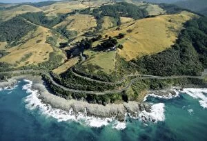
Aerial - Great Ocean Road & Sunnyside Road Otway Ranges near Apollo Bay, Victoria, Australia JLR06487JLR-227 Aerial - Great Ocean Road & Sunnyside Road Otway Ranges near Apollo Bay Victoria, Australia Jean-marc La Roque Please note that prints are for personal display purposes only
Point Lonsdale, the Rip and Pointt Nepean Melbourne, Victoria, Australia JLR06924JLR-352 Point Lonsdale, the Rip and Pointt Nepean Melbourne Victoria, Australia Jean-marc La Roque Please note that prints are for personal display purposes only and may not be reproduced in anyway
The Rip, entrance to Port Phillip Bay Point Nepean and Point Lonsdale in background; Melbourne, VictoriaJLR-351 The Rip, entrance to Port Phillip Bay Point Nepean and Point Lonsdale in background Melbourne, Victoria, Australia Jean-marc La Roque Please note that prints are for personal display purposes
Utala'aina Bay Vava'u Island, Vava'u Group, Tonga JLR06081JLR-333 Utala aina Bay Vava u Island Vava u Group, Tonga Jean-marc La Roque Please note that prints are for personal display purposes only and may not be reproduced in anyway
Aerial - Kolonia, the capital Pohnpei Island, Micronesia JLR04131JLR-304 Aerial - Kolonia, the capital Pohnpei Island, Micronesia Jean-marc La Roque Please note that prints are for personal display purposes only and may not be reproduced in anyway
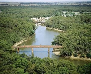
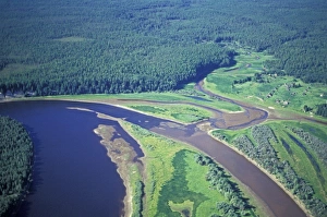
Port of Echuca on Murray River Northeastern Victoria, Australia JLR01377JLR-126 Port of Echuca on Murray River Northeastern Victoria Australia Jean-marc La Roque Please note that prints are for personal display purposes only and may not be reproduced in anyway
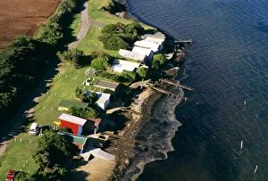
Aerial - Beach houses - Werribee, near Melbourne, Victoria, Australia JLR05064JLR-209 Aerial - Beach houses - Werribee near Melbourne, Victoria, Australia Jean-marc La Roque Please note that prints are for personal display purposes only and may not be reproduced in anyway
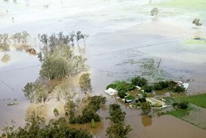
Shepparton flood, 1993 - aerial of farm during the flood - northeastern Victoria, Australia JLR04698JLR-186 Shepparton flood, 1993 - aerial of farm during the flood northeastern Victoria, Australia Jean-marc La Roque Please note that prints are for personal display purposes only
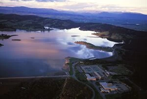
Yan Yean Reservoir Melbourne, Victoria, Australia JLR02368JLR-143 Yan Yean Reservoir Melbourne Victoria, Australia Jean-marc La Roque Please note that prints are for personal display purposes only and may not be reproduced in anyway
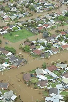
Streets under water aerial, Shepparton, Northeastern Victoria, Australia, 1993 JLR04586JLR-185 Streets under water aerial, Shepparton Northeastern Victoria, Australia, 1993 Jean-marc La Roque Please note that prints are for personal display purposes only
Aerial - Minefield - Coober Pedy, South Australia JLR05253JLR-203 Aerial - Minefield - Coober Pedy South Australia Jean-marc La Roque Please note that prints are for personal display purposes only and may not be reproduced in anyway
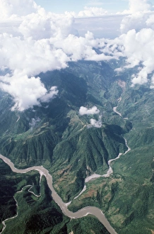
Egypt River Nile, near Luxor (aerial)JG-3705 Egypt - River Nile, near Luxor Ardea London Please note that prints are for personal display purposes only and may not be reproduced in anyway
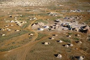
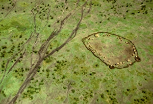
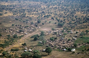
Aerial: Maasai village and vehicle tracks, Masai Mara, Kenya JFL14122FL-3273 Aerial: Maasai village and vehicle tracks Maasai Mara, Kenya Ferrero Labat Please note that prints are for personal display purposes only and may not be reproduced in anyway
Siberian Taiga - Ural Mountains - SiberiaCAN-3546 Siberian Taiga Ural Mountains - Siberia John Cancalosi Please note that prints are for personal display purposes only and may not be reproduced in anyway
Nepal - Himalayas foothillsBMD-40 Nepal - Himalayas foothills Brian McDairmant Please note that prints are for personal display purposes only and may not be reproduced in anyway
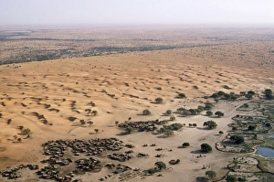
West Africa - village & sand dunes Burkina Faso is a landlocked nation in West AfricaBMD-106 West Africa - village & sand dunes Burkina Faso is a landlocked nation in West Africa. Brian McDairmant Please note that prints are for personal display purposes only
West Africa - village near Bobo Burkina Faso is a landlocked nation in West AfricaBMD-100 West Africa - village near Bobo Burkina Faso is a landlocked nation in West Africa. Brian McDairmant Please note that prints are for personal display purposes only
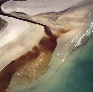
Aerial image of Scotland, UK: Sinclair's Bay, south of Keiss, north-east Caithness, east coast of ScotlandAW-6851 Aerial image of Scotland, UK: Sinclair's Bay south of Keiss, north-east Caithness, east coast of Scotland. Water of the Burn of Lyth flows through Loch of Wester
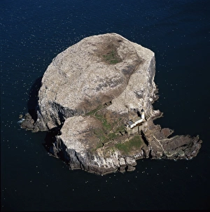
Aerial image of Scotland, UK: Bass Rock (The Bass), Volcanic plug of Phonolite in the Firth of Forth, near AuldhameAW-6841 Aerial image of Scotland, UK: Bass Rock (The Bass) Volcanic plug of Phonolite in the Firth of Forth, near Auldhame, East Lothian
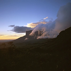
Mount Kukenaam (Kukenan, Kukenan, Cuguenan) from the upper slopes of Roraima, Gran Sabana, Estado Boliovar, VenezuelaAW-6719 Mount Kukenaam (Kukenan, Kukenan, Cuguenan) from the upper slopes of Roraima Gran Sabana, Estado Boliovar, Venezuela
Aerial image of Venezuela, South America: Skeleton forest (damaged from forest fire) on La Gran SabanaAW-6749 Aerial image of Venezuela, South America Skeleton forest (damaged from forest fire) on La Gran Sabana, Canaima National Park
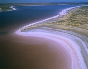
Lake Eyre North - dry salt lake that floods a few times each century and Jackboot BayAUS-1894 Lake Eyre North - dry salt lake that floods a few times each century and Jackboot Bay, along Hunt Peninsula (Elliot Price Conservation Park) fills with pink tinted water (algae)
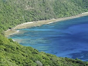
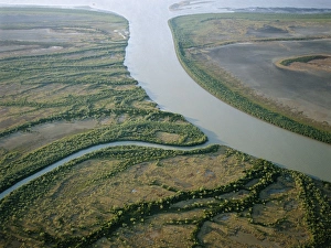
Australia Bynoe River floodplain, Gulf of Carpentaria, QueenslandAU-41-law AUSTRALIA - Coastal wetland wilderness of the Bynoe River floodplain near its mouth Gulf of Carpentaria, Queensland, Australia Showing tidal saltflats and mangrove lined channels
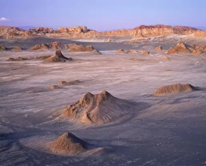
Chile - Valle De Le Luna (Valley of the Moon). Driest place on earth, Atacama Desert, Los Flamencos National ReserveAU-5-PLA Chile - Valle De Le Luna (Valley of the Moon). Driest place on earth, Atacama Desert, Los Flamencos National Reserve Auscape Please note that prints are for personal display purposes only
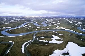
Arctic tundra - aerial view from a helicopter. A typical landscape near Kara sea, Taimyr peninsula, North of SiberiaANZ-996 Arctic tundra - aerial view from a helicopter. landscape near Kara sea, Taimyr peninsula, North of Siberia, Russian Arctic. Summer, July
Semi-tundra, aerial view from a helicopter. A typical landscape near large lake Pyasina, Taimyr peninsulaANZ-993 Semi-tundra, aerial view from a helicopter. landscape near large lake Pyasina, Taimyr peninsula, North of Siberia, Russian Arctic, summer
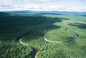
Russia Aerial. Coniferous boreal forest. Taiga Forest & river, North Ural MountainsANZ-683 RUSSIA - North Urals Mountains, Aerial, view Taiga Forest, Ural mountains, Russia Andrey Zvoznikov Please note that prints are for personal display purposes only
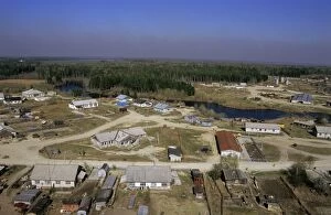
Maloyuganskii village, aerial view over the village and taiga-forest, a fog visible over horizon due to uncontrolledANZ-788 Maloyuganskii village - aerial of village and taiga forest near Surgut, Siberia, Russia. Spring Fog visible on the horizon is due to smoke from uncontrolled forest fires
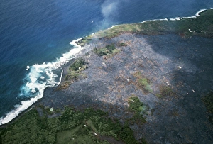
Hawaii - Kalapana gardens destroyed by lavaFG-5714 Hawaii - Kalapana gardens destroyed by lava from volcano Francois Gohier Please note that prints are for personal display purposes only and may not be reproduced in anyway
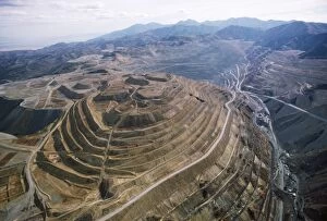
Copper Mine - Kennecott open pit, largest in Northern America. Utah, USAFG-4240 COPPER Mine - Kennecott open pit, largest in Northern America Utah, USA Francois Gohier Please note that prints are for personal display purposes only and may not be reproduced in anyway
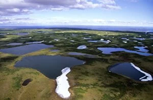
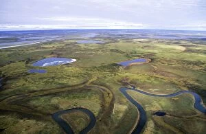
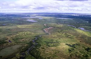
Tundra - lakes and rivers - an aerial view from a helicopter. A smaller river has an old river-bed, on foregroundANZ-1298 Tundra - lakes and rivers - an aerial view from a helicopter. A smaller river has an old river-bed, on foreground
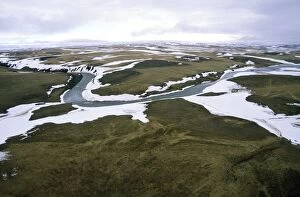
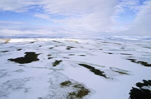
Snow melts in arctic tundra spring. Aerial view from a helicopter. A typical landscape near Kara sea, Taimyr peninsulaANZ-1305 Snow melts in arctic tundra spring. Aerial view from a helicopter. landscape near Kara sea, Taimyr peninsula, North of Siberia, Russian Arctic. July
Tundra - aerial view from a helicopter. A typical landscape in Taimyr peninsula, North of Siberia, Russian ArcticANZ-1297 Tundra - aerial view from a helicopter. Taimyr peninsula, North of Siberia, Russian Arctic, summer Andrey Zvoznikov Please note that prints are for personal display purposes only
Arctic tundra in spring - an aerial view from a helicopter. A typical landscape near Kara sea, Taimyr peninsulaANZ-1310 Arctic tundra in spring - an aerial view from a helicopter. landscape near Kara sea, Taimyr peninsula, North of Siberia, Russian Arctic. Summer, July