mail_outline sales@mediastorehouse.com
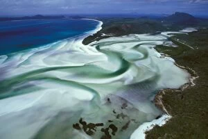
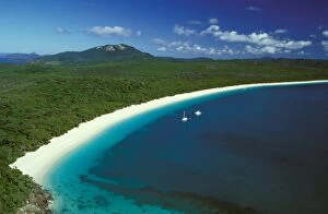
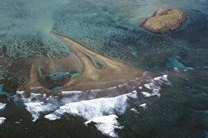
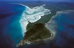
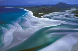
Hill Inlet, Whitehaven Beach, Whitsunday Islands Whitsunday Group, Great Barrier Reef Marine Park (World Heritage Area)JPF-13376 Hill Inlet, Whitehaven Beach Whitsunday Islands Whitsunday Group, Great Barrier Reef Marine Park (World Heritage Area), Queensland
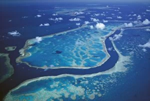
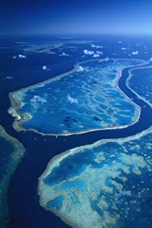
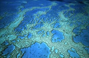
Hardy Reef separated from Hook Reef by deep tidal channel Hardy Reef, Great Barrier Reef Marine ParkJPF-13375 Hardy Reef separated from Hook Reef by deep tidal channel Hardy Reef, Great Barrier Reef Marine Park (World Heritage Area), Queensland
Hook Reef - separated from Hardy Reef (top) by a deep tidal channel, Great Barrier Reef Marine ParkJPF-13374 Hook Reef - separated from Hardy Reef (top) by a deep tidal channel, Great Barrier Reef Marine Park (World Heritage Area), Queensland
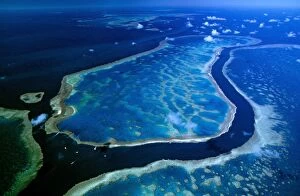
Hardy & Hook Reefs separated by deep channel, Hardy Reef, Great Barrier Reef Marine Park (World Heritage Area)JPF-13371 Hardy & Hook Reefs separated by deep channel, Hardy Reef, Great Barrier Reef Marine Park (World Heritage Area), Queensland
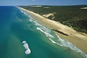
Maheno wreck on Maheno Beach, Great Sandy National Park, Fraser Island, Queensland, Australia JPF33695JPF-13357 Maheno wreck on Maheno Beach Great Sandy National Park, Fraser Island, Queensland, Australia Jean-Paul Ferrero Please note that prints are for personal display purposes only
Whitehaven Beach, Whitsunday Island Whitsunday Group, Great Barrier Reef Marine Park (World Heritage Area), QueenslandJPF-13356 Whitehaven Beach, Whitsunday Island Whitsunday Group Great Barrier Reef Marine Park (World Heritage Area), Queensland
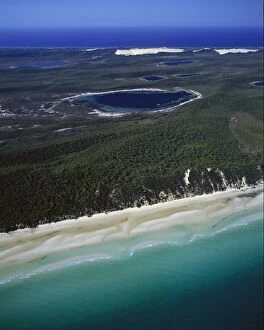
Aerial of Platypus Bay with lakes and lagoons, Great Sandy National Park, Fraser Island, Queensland, Australia JPF33763JPF-13355 Aerial of Platypus Bay with lakes and lagoons Great Sandy National Park, Fraser Island, Queensland, Australia Jean-Paul Ferrero Please note that prints are for personal display purposes
Hardy Reef separated from Hook Reef by deep channel, Great Barrier Reef Marine Park (World Heritage Area), QueenslandJPF-13354 Hardy Reef separated from Hook Reef by deep channel Great Barrier Reef Marine Park (World Heritage Area), Queensland
Lagoon and Rabbit Island from the air, Lord Howe Island, New South Wales, Australia JPF32733JPF-13333 Lagoon and Rabbit Island from the air Lord Howe Island, New South Wales, Australia Jean-Paul Ferrero Please note that prints are for personal display purposes only
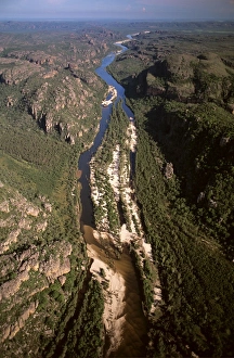
East Alligator River Gorge aerial looking downstream, Kakadu National Park (World Heritage Area), Northern TerritoryJPF-13224 East Alligator River Gorge aerial looking downstream Kakadu National Park (World Heritage Area), Northern Territory
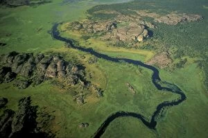
Aerial view - Billabong & limestone outcrops Cannon Hill, East Alligator regionJPF-13206 Aerial view - Billabong & limestone outcrops Cannon Hill, East Alligator region, Kakadu National Park (World Heritage Area), Northern Territory
Gordon Dam detail of the dam wall. Part of the hydro-electric scheme for Tasmania, Gordon River, TasmaniaJPF-13172 Gordon Dam detail of the dam wall. Part of the hydro-electric scheme for Tasmania, Gordon River, Tasmania, Australia Jean-Paul Ferrero Please note that prints are for personal display
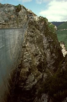
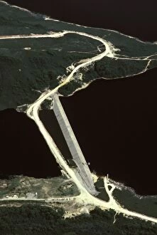
Gordon Dam - aerial image part of the hydro-electric scheme for Tasmania, Gordon River, Tasmania, Australia JPF24475JPF-13156 Gordon Dam - aerial image part of the hydro-electric scheme for Tasmania Gordon River, Tasmania, Australia Jean-Paul Ferrero Please note that prints are for personal display purposes only
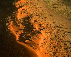
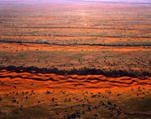
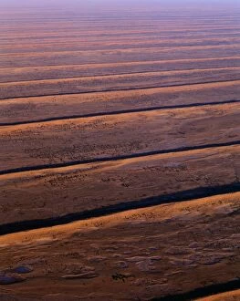
Dunefields & Salt Lakes (playas) Simpson Desert, South Austraia JPF41706JPF-13136 Dunefields & Salt Lakes (playas) Simpson Desert, South Austraia Jean-Paul Ferrero Please note that prints are for personal display purposes only and may not be reproduced in any way
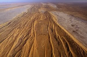
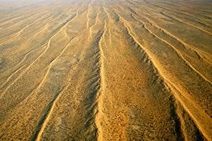
Sand dunes and corridor near Old Andado Station, Simpson Desert, Northern Territory, Australia JPF45048JPF-13133 Sand dunes and corridor near Old Andado Station Simpson Desert, Northern Territory, Australia Jean-Paul Ferrero Please note that prints are for personal display purposes only
Tanami Desert vegetation: spinifex, desert oaks & acacias Northern Territory, Australia JPF45095JPF-13132 Tanami Desert vegetation: spinifex, desert oaks & acacias Northern Territory, Australia Jean-Paul Ferrero Please note that prints are for personal display purposes only
Great Victoria Desert South Australia JPF47890JPF-13129 Great Victoria Desert South Australia Jean-Paul Ferrero Please note that prints are for personal display purposes only and may not be reproduced in any way
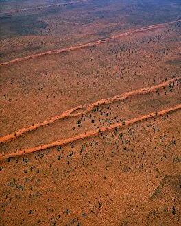
Longitudinal sand dunes - Strzelecki Desert, South Australia JPF41251JPF-13109 Longitudinal sand dunes Strzelecki Desert, South Australia Jean-Paul Ferrero Please note that prints are for personal display purposes only and may not be reproduced in any way
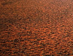
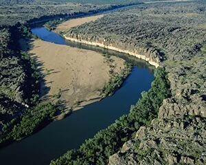
Western Australia - river cutting through ancient limestone coral reef formed during Devonian PeriodJPF-12857 Western Australia - river cutting through ancient limestone coral reef formed during Devonian Period (350 million years ago)
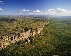
Australia Arnhem Land Escarpment, Kakadu National Park, National Terretory, AustraliaJPF-12747 AUSTRALIA - Northern Territory, Amhem Land Escarpment Kakadu National Park Jean Paul Ferrero Please note that prints are for personal display purposes only
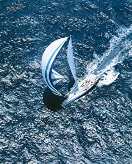
Yacht Race JPF 12617 Sydney to Hobart yacht race - December 26th 1998 © Jean-Paul Ferrero / ARDEA LONDONJPF-12617 Australia - Sydney to Hobart yacht race Sydney, NSW Boxing Day, December 26, 1998 Jean Paul Ferrero Please note that prints are for personal display purposes only
Australia JPF 12204 Northern territory Kakadu National Park. Magela wetlands during the wet seasonJPF-12204 Australia - Northern territory Kakadu National Park Magela wetlands during the wet season. Birds, mostly egrets also Ducks
Western Australia Kimberley region Talbot Bay IslandsJPF-11597 Western Australia Kimberley region Talbot Bay Islands Jean Paul Ferrero Please note that prints are for personal display purposes only and may not be reproduced in any way
South Australia JPF 11327 Flinders Ranger National Park Wilpena Pound © Jean-Paul Ferrero / ARDEA LONDONJPF-11327 South Australia - Wilpena Pound Flinders Range, National Park. Ancient range of mountains that have been eroded away over millions of years
Australia - dunefields. Sand dunes & claypans in interdune corridors South-eastern Simpson, South AustraliaJPF-11313 Australia - dunefields South-eastern Simpson, South Australia. sand dunes & claypans in interdune corridors Jean Paul Ferrero Please note that prints are for personal display purposes only
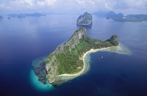
Philippines Palawan Biscuit Bay near El Nido, Malapacao IslandJPF-10567 PHILIPPINES - Palawan - Bacuit Bay, Malapacao Island Jean Paul Ferrero Please note that prints are for personal display purposes only and may not be reproduced in any way
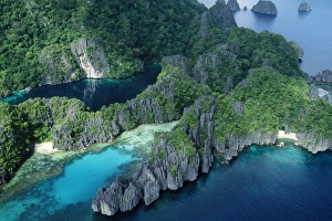
Philippines - the lagoons Bacuit Bay Miniloc Island, Palawan, PhilippinesJPF-10564 Philippines - the lagoons Bacuit Bay Miniloc Island, Palawan, Philippines. Jean Paul Ferrero Please note that prints are for personal display purposes only
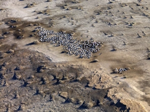
Lake Eyre north South Australia. 2009 flood - Pelicans nesting on an island - Lake Eyre is an extensive salt sinkJLR-91 Lake Eyre north South Australia. 2009 flood - Pelicans nesting on an island - Lake Eyre is an extensive salt sink and has only filled to capacity three times in the past 150 years
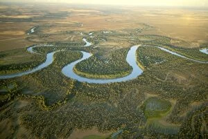
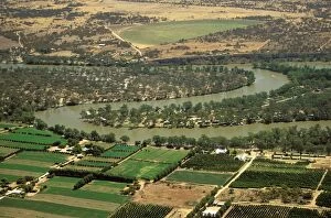
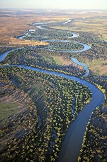
Aerial - Murray River and its meanders between Wentworth, New South Wales and Renmark, South Australia JLR06671JLR-365 Aerial - Murray River and its meanders between Wentworth New South Wales and Renmark, South Australia Jean-marc La Roque Please note that prints are for personal display purposes only
Lakes Entrance, Cunninghame Arm, South Gippsland Lakes, Victoria, Australia JLR06763JLR-362 Lakes Entrance, Cunninghame Arm South Gippsland Lakes, Victoria, Australia Jean-marc La Roque Please note that prints are for personal display purposes only
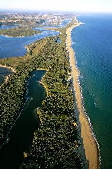
Hopetoun Channel, Ninety Mile Beach, Lakes Entrance, South Gippsland Lakes, Victoria, Australia JLR06768JLR-361 Hopetoun Channel, Ninety Mile Beach, Lakes Entrance South Gippsland Lakes, Victoria, Australia Jean-marc La Roque Please note that prints are for personal display purposes only
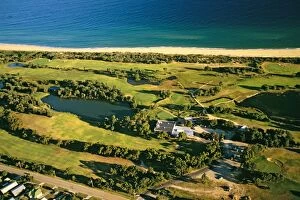
Aerial - Lakes Entrance golf course - South Gippsland Lakes, Victoria, Australia JLR06779JLR-356 Aerial - Lakes Entrance golf course South Gippsland Lakes, Victoria, Australia Jean-marc La Roque Please note that prints are for personal display purposes only
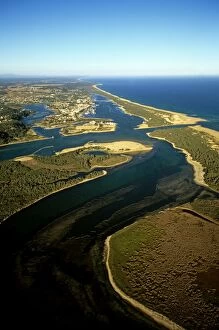
Aerial - Lakes Entrance, Hopetoun Channel aerial South Gippsland Lakes, Victoria, Australia JLR06781JLR-355 Aerial - Lakes Entrance, Hopetoun Channel aerial South Gippsland Lakes, Victoria, Australia Jean-marc La Roque Please note that prints are for personal display purposes only
Aerial - Lakes Entrance, Ninety Mile Beach, South Gippsland Lakes, Victoria, Australia JLR06786JLR-354 Aerial - Lakes Entrance, Ninety Mile Beach South Gippsland Lakes, Victoria, Australia Jean-marc La Roque Please note that prints are for personal display purposes only
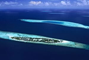
Aerial - Ari Atoll Maldives JLR05187JLR-321 Aerial - Ari Atoll Maldives Jean-marc La Roque Please note that prints are for personal display purposes only and may not be reproduced in any way
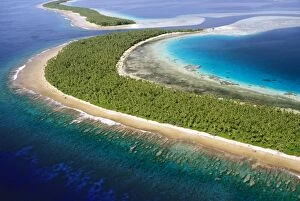
Aerial - Ant Atoll SW of Pohnpei - Tauenai Passage Pohnpei, Micronesia JLR04120JLR-305 Aerial - Ant Atoll SW of Pohnpei Tauenai Passage Pohnpei, Micronesia Jean-marc La Roque Please note that prints are for personal display purposes only and may not be reproduced in any way
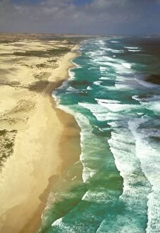
Aerial - Discovery Bay Coastal Park Victoria, Australia JLR06505JLR-226 Aerial - Discovery Bay Coastal Park Victoria, Australia Jean-marc La Roque Please note that prints are for personal display purposes only and may not be reproduced in any way
Aerial - Murray River irrigation: citrus orchards - between Swan Reach & Waikerie, South Australia JLR06609JLR-224 Aerial - Murray River irrigation: citrus orchards - between Swan Reach & Waikerie South Australia Jean-marc La Roque Please note that prints are for personal display purposes only
Aerial - South Australia - The Murray River and its meanders between Wentworth, New South Wales and RenmarkJLR-222 Aerial - South Australia - The Murray River and its meanders between Wentworth New South Wales and Renmark, South Australia Jean-marc La Roque Please note that prints are for personal display
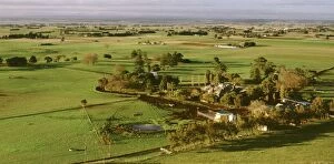
Dairy landscape near Colac Victoria, Australia JLR07646JLR-216 Dairy landscape near Colac Victoria Australia Jean-marc La Roque Please note that prints are for personal display purposes only and may not be reproduced in any way
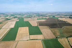
Farming - Fen Farmland Cambridgeshire UKJLM-7103 FARMING - Fen farmland Cambridgeshire UK John Mason Please note that prints are for personal display purposes only and may not be reproduced in any way
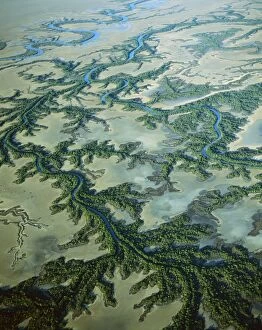
Aerial - Roper River delta with saline flats and mangrove-lined dendritic channels, Gulf of CarpentariaJPF-13812 Aerial - Roper River delta with saline flats and mangrove-lined dendritic channels Gulf of Carpentaria, Northern Territory
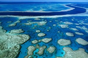
Hardy Reef aerial of coral formations, Great Barrier Reef Marine Park (World Heritage Area), QueenslandJPF-13381 Hardy Reef aerial of coral formations Great Barrier Reef Marine Park (World Heritage Area), Queensland, Australia Jean-Paul Ferrero Please note that prints are for personal display purposes
Whitehaven Beach Whitsunday Group, Great Barrier Reef Marine Park (World Heritage Area), Queensland, Australia JPF34502JPF-13377 Whitehaven Beach Whitsunday Group Great Barrier Reef Marine Park (World Heritage Area), Queensland, Australia Jean-Paul Ferrero Please note that prints are for personal display purposes
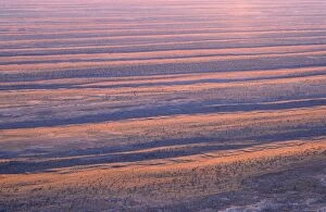
Aerial view - Dunefields, dunes and interdune corridors 30m+ high and rarely branched, Central-east Simpson DesertJPF-13139 Aerial view - Dunefields, dunes and interdune corridors 30m+ high and rarely branched Central-east Simpson Desert, South Australia
Aerial of dunefields, sand dunes and claypans in interdune corridors, southeastern Simpson DesertJPF-13134 Aerial of dunefields, sand dunes and claypans in interdune corridors southeastern Simpson Desert, South Australia Jean-Paul Ferrero Please note that prints are for personal display purposes
Hill Inlet, Whitehaven Beach Great Barrier Reef Marine Park (World Heritage Area), Queensland, Australia JPF34522JPF-13402 Hill Inlet, Whitehaven Beach Great Barrier Reef Marine Park (World Heritage Area), Queensland, Australia Jean-Paul Ferrero Please note that prints are for personal display purposes only
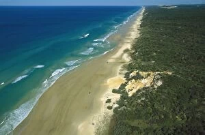
Seventy Five Mile Beach Great Sandy National Park, Fraser Island, Queensland, Australia JPF33691JPF-13358 Seventy Five Mile Beach Great Sandy National Park Fraser Island, Queensland, Australia Jean-Paul Ferrero Please note that prints are for personal display purposes only