mail_outline sales@mediastorehouse.com
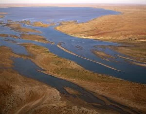
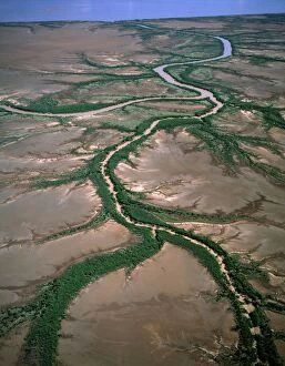
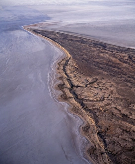
Aerial - Margaret River flowing into L. Eyre South Lake Eyre National Park, South Australia JPF46553JPF-13729 Aerial - Margaret River flowing into Lake Eyre South Lake Eyre National Park, South Australia Jean-Paul Ferrero Please note that prints are for personal display purposes only
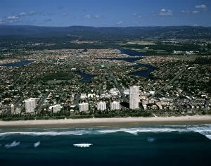
Areial - Miami - North Burleigh Beach, Gold Coast, Queensland JPF46578JPF-13708 Aerial - Miami - North Burleigh Beach, Gold Coast, Queensland Jean-Paul Ferrero Please note that prints are for personal display purposes only and may not be reproduced in anyway
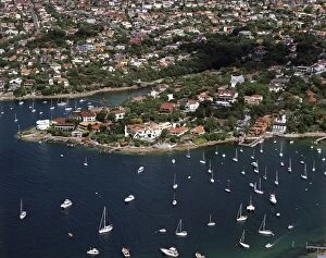
Vaucluse Bay and Parsley Bay Sydney Harbour, New South Wales, Australia JPF45369JPF-13695 Vaucluse Bay and Parsley Bay Sydney Harbour New South Wales, Australia Jean-Paul Ferrero Please note that prints are for personal display purposes only and may not be reproduced in anyway
Aerial of Neilsen Park, Vaucluse Bay and Parsley Bay during Tall Ships race, Sydney Harbour, New South WalesJPF-13693 Aerial of Neilsen Park, Vaucluse Bay and Parsley Bay during Tall Ships race Sydney Harbour, New South Wales, Australia
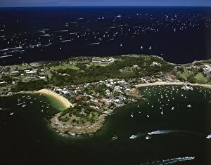
Aerial of Camp Cove, Laings Point and Watsons Bay during Tall Ships race, Sydney Harbour, New South Wales, AustraliaJPF-13692 Aerial of Camp Cove, Laings Point and Watsons Bay during Tall Ships race Sydney Harbour, New South Wales, Australia
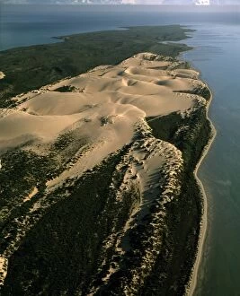
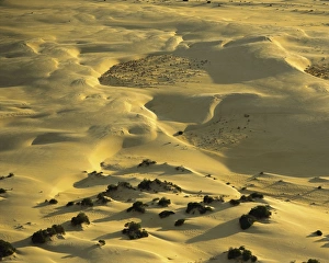
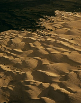
Aerial - Bellefin Prong sand dunes, Shark Bay Marine Park, Western Australia JPF44917JPF-13682 Aerial - Bellefin Prong sand dunes Shark Bay Marine Park, Western Australia Jean-Paul Ferrero Please note that prints are for personal display purposes only
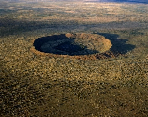
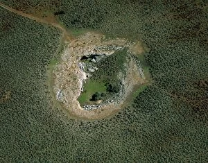
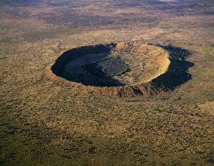
Wolfe Creek Crater - Wolfe Creek Crater National Park, Kimberley region, Western Australia JPF43544JPF-13605 Wolfe Creek Crater - Wolfe Creek Crater National Park Kimberley region, Western Australia Jean-Paul Ferrero Please note that prints are for personal display purposes only
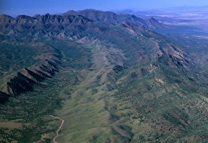
South of Brachina Gorge Flinders Ranges National Park, South Australia JPF42895JPF-13584 South of Brachina Gorge Flinders Ranges National Park, South Australia Jean-Paul Ferrero Please note that prints are for personal display purposes only and may not be reproduced in anyway
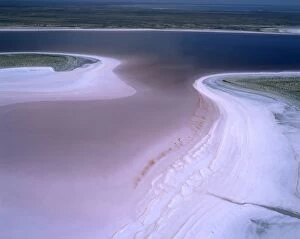
Lake MacLeod salt lake mineral-laden artesian water surfacing on lake's edge. Aerial. Western Australia JPF44357JPF-13627 Lake MacLeod salt lake mineral-laden artesian water surfacing on lakes edge Aerial. Western Australia Jean-Paul Ferrero Please note that prints are for personal display purposes only
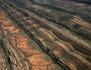
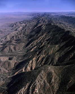
Aerial - South Flinders Ranges South Australia JPF42982JPF-13583 Aerial - South Flinders Ranges South Australia Jean-Paul Ferrero Please note that prints are for personal display purposes only and may not be reproduced in anyway
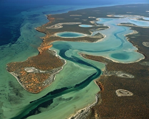
Big Lagoon Aerial from 2000 feet. Francois Peron National Park, Shark Bay, Western Australia JPF43555JPF-13602 Big Lagoon Aerial from 2000 feet. Francois Peron National Park, Shark Bay, Western Australia Jean-Paul Ferrero Please note that prints are for personal display purposes only
Aerial: ‘The Pinnacles Nambung National Park, Western Australia JPF43790JPF-13619 Aerial: The Pinnacles Nambung National Park, Western Australia Jean-Paul Ferrero Please note that prints are for personal display purposes only and may not be reproduced in anyway
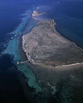
Aerial - Easter Group (Rat & Little Islands) with lobster fishermen's houses, Houtman Abrolhos IslandsJPF-13670 Aerial - Easter Group (Rat & Little Islands) with lobster fishermens houses Houtman Abrolhos Islands, Western Australia Jean-Paul Ferrero Please note that prints are for personal display
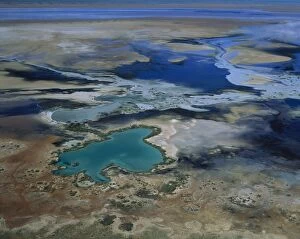
Aerial - Lake Eyre National Park (south) South Australia JPF44343JPF-13631 Aerial - Lake Eyre National Park (south) South Australia Jean-Paul Ferrero Please note that prints are for personal display purposes only and may not be reproduced in anyway
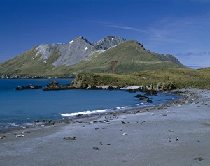
Cooper Bay and Cooper Island, South Georgia, Antarctica Elephant seals, Fur seals and Penguins JPF41817JPF-13577 Cooper Bay and Cooper Island South Georgia, Antarctica Elephant seals, Fur seals and Penguins Jean-Paul Ferrero Please note that prints are for personal display purposes only
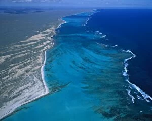
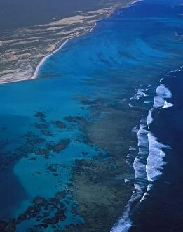
Ningaloo Reef aerial, Ningaloo Marine Park, Western Australia JPF44352JPF-13629 Ningaloo Reef aerial Ningaloo Marine Park, Western Australia Jean-Paul Ferrero Please note that prints are for personal display purposes only and may not be reproduced in anyway
Aerial - Madura Cave - a sinkhole Nullarbor Plain, Western Australia JPF44465JPF-13637 Aerial - Madura Cave a sinkhole Nullarbor Plain, Western Australia Jean-Paul Ferrero Please note that prints are for personal display purposes only and may not be reproduced in anyway
Aerial: Ningaloo Reef Ningaloo Marine Park, Western Australia JPF44353JPF-13628 Aerial: Ningaloo Reef Ningaloo Marine Park Western Australia Jean-Paul Ferrero Please note that prints are for personal display purposes only and may not be reproduced in anyway
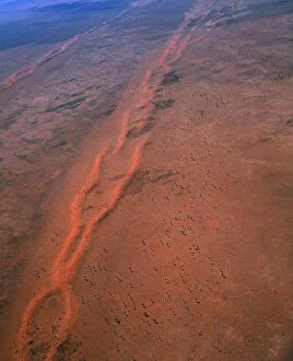
Aerail - Tanami Desert - Northern Territory - Australia JPF45096JPF-13675 Aerial - Tanami Desert Northern Territory - Australia Jean-Paul Ferrero Please note that prints are for personal display purposes only and may not be reproduced in anyway
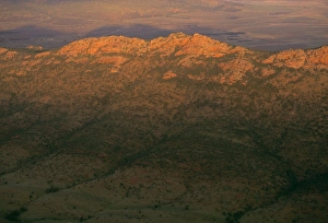
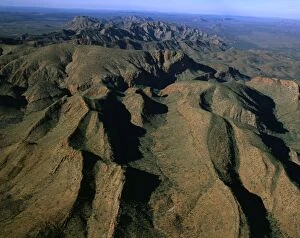
Aerial - Brinkley Bluff area West MacDonnell National Park, Northern Territory, Australia JPF44756JPF-13662 Aerial - Brinkley Bluff area West MacDonnell National Park Northern Territory, Australia Jean-Paul Ferrero Please note that prints are for personal display purposes only
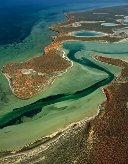
Big Lagoon, Shark Bay Western Australia JPF43573JPF-13601 Big Lagoon, Shark Bay Western Australia Jean-Paul Ferrero Please note that prints are for personal display purposes only and may not be reproduced in anyway
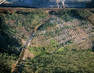
Aerial - Resurfacing and replanting former open-cut iron mine aerial, Koolan Island, Western Australia JPF45635JPF-13687 Aerial - Resurfacing and replanting former open-cut iron mine aerial Koolan Island, Western Australia Jean-Paul Ferrero Please note that prints are for personal display purposes only
Aerial: sand dunes Nambung National Park, Western Australia JPF43782JPF-13620 Aerial: sand dunes Nambung National Park Western Australia Jean-Paul Ferrero Please note that prints are for personal display purposes only and may not be reproduced in anyway
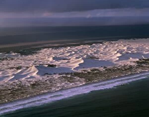
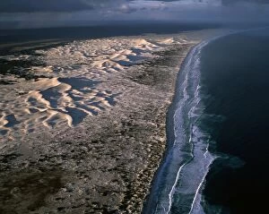
Coastal dunes Nuytsland Nature Reserve, Western Australia JPF45648JPF-13684 Coastal dunes Nuytsland Nature Reserve Western Australia Jean-Paul Ferrero Please note that prints are for personal display purposes only and may not be reproduced in anyway
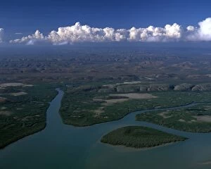
Aerial - King Sound near Derby: tidal flats, mangrove-lined river and dendritic drainage Kimberley regionJPF-13677 Aerial - King Sound near Derby: tidal flats, mangrove-lined river and dendritic drainage Kimberley region Western Australia Jean-Paul Ferrero Please note that prints are for personal
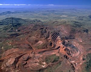
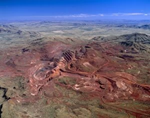
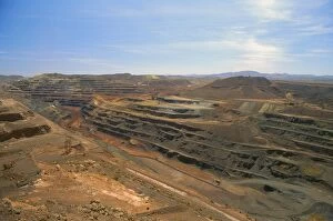
Aerial - Tom Price iron ore-open cut mine Hamersley Range, Pilbara Region, Western Australia JPF45003JPF-13679 Aerial - Tom Price iron ore-open cut mine Hamersley Range Pilbara Region, Western Australia Jean-Paul Ferrero Please note that prints are for personal display purposes only
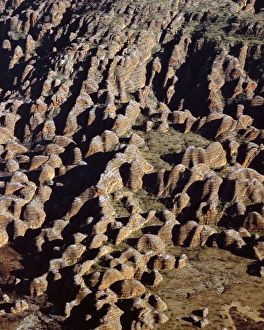
Aerial: Bungle Bungle Range Purnululu National Park, Kimberley region, Western Australia JPF43703JPF-13621 Aerial: Bungle Bungle Range Purnululu National Park Kimberley region, Western Australia Jean-Paul Ferrero Please note that prints are for personal display purposes only
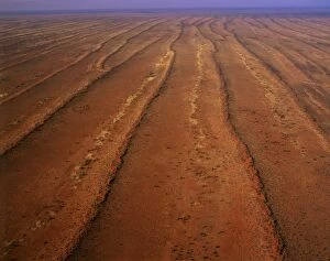
Aerial - Desert - parallel longitudinal sand dunes and sandy interdune corridors, north west Simpson DesertJPF-13678 Aerial - Desert - parallel longitudinal sand dunes and sandy interdune corridors north west Simpson Desert, Northern Territory
Booth Island Antarctic Peninsula JPF41796JPF-13575 Booth Island Antarctic Peninsula Jean-Paul Ferrero Please note that prints are for personal display purposes only and may not be reproduced in anyway
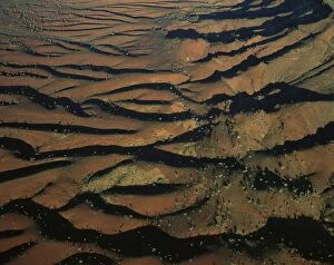
Aerial - North Flinders Ranges, aerial South Australia JPF43064JPF-13580 Aerial - North Flinders Ranges aerial South Australia Jean-Paul Ferrero Please note that prints are for personal display purposes only and may not be reproduced in anyway
Aerial - Coastal dunes between Wylie Scarp & Southern ocean (Great Australian Bight) Nuytsland Nature ReserveJPF-13685 Aerial - Coastal dunes between Wylie Scarp & Southern ocean (Great Australian Bight) Nuytsland Nature Reserve, Western Australia Jean-Paul Ferrero Please note that prints are for personal
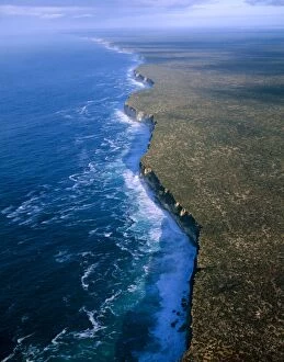
Aerial - Baxter Cliffs at edge of Nullarbor Plain Nuytsland Nature Reserve, Great Australian BightJPF-13633 Aerial - Baxter Cliffs at edge of Nullarbor Plain Nuytsland Nature Reserve, Great Australian Bight, Western Australia Jean-Paul Ferrero Please note that prints are for personal display
Aerial - King Sound: mangrove-lined river & hills Kimberley region, Western Australia JPF44711JPF-13666 Aerial - King Sound: mangrove-lined river & hills Kimberley region, Western Australia Jean-Paul Ferrero Please note that prints are for personal display purposes only
Wolfe Creek meteor crater, aerial Wolfe Creek Crater National Park, Kimberley region, Western Australia JPF43550JPF-13603 Wolfe Creek meteor crater, aerial Wolfe Creek Crater National Park, Kimberley region, Western Australia Jean-Paul Ferrero Please note that prints are for personal display purposes only
Aerial - Tom Price open-cut iron ore mine Hamersley Range, Pilbara Region, Western Australia JPF44455JPF-13638 Aerial - Tom Price open-cut iron ore mine Hamersley Range Pilbara Region, Western Australia Jean-Paul Ferrero Please note that prints are for personal display purposes only
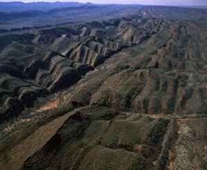
Aerial - Folded mountains near Glen Helen & Finke Gorge West MacDonnell National Park, Northern TerritoryJPF-13665 Aerial - Folded mountains near Glen Helen & Finke Gorge West MacDonnell National Park, Northern Territory, Australia Jean-Paul Ferrero Please note that prints are for personal display
Aerial: MacDonnell ranges near Finke Gorge, Northern Territory, Australia JPF43849JPF-13614 Aerial: MacDonnell ranges near Finke Gorge Northern Territory, Australia Jean-Paul Ferrero Please note that prints are for personal display purposes only
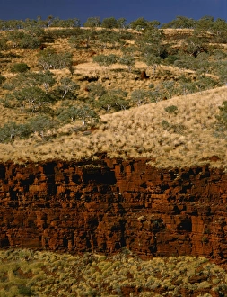
Aerial: south-western side of Hamersley Range the Pilbara seabed rose to form one of Earth's first permanent landJPF-13630 Aerial: south-western side of Hamersley Range Pilbara region, Western Australia the Pilbara seabed rose to form one of Earths first permanent land masses about 3.5 billion years ago
Aerial - Simpson Desert near Dalhousie homestead, Witjira National Park, northeastern South Australia JPF45567JPF-13689 Aerial - Simpson Desert near Dalhousie homestead Witjira National Park, northeastern South Australia Jean-Paul Ferrero Please note that prints are for personal display purposes only
Bungle Bungle Range Purnululu National Park, Kimberley region, Western Australia JPF43641JPF-13599 Bungle Bungle Range Purnululu National Park Kimberley region, Western Australia Jean-Paul Ferrero Please note that prints are for personal display purposes only
Lake Eyre north Elliott Price Conservation Park, Sth Australia JPF41355JPF-13563 Lake Eyre north Elliott Price Conservation Park Sth Australia Jean-Paul Ferrero Please note that prints are for personal display purposes only and may not be reproduced in anyway
North of Brachina Gorge Flinders Ranges National Park, South Australia JPF41751JPF-13557 North of Brachina Gorge Flinders Ranges National Park, South Australia Jean-Paul Ferrero Please note that prints are for personal display purposes only and may not be reproduced in anyway
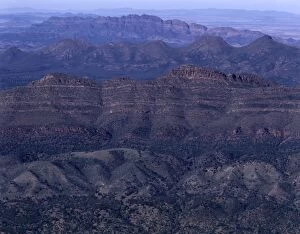
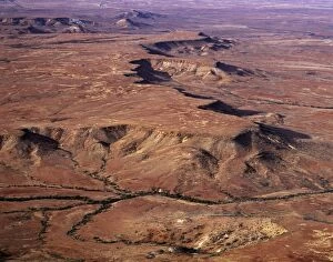
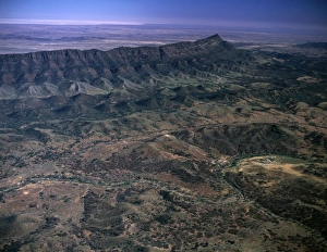
Southern Flinders Ranges Aerial South Australia JPF41777JPF-13556 Southern Flinders Ranges Aerial South Australia Jean-Paul Ferrero Please note that prints are for personal display purposes only and may not be reproduced in anyway
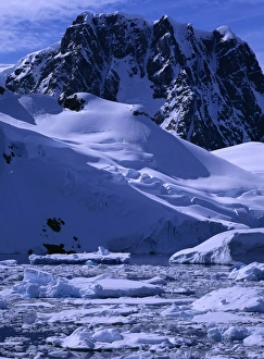
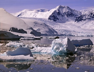
Southern end of Lemaire Channel Girard Bay, Antarctic Peninsula JPF41789JPF-13553 Southern end of Lemaire Channel Girard Bay Antarctic Peninsula Jean-Paul Ferrero Please note that prints are for personal display purposes only and may not be reproduced in anyway
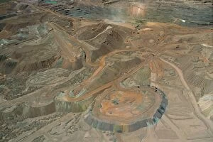
Mount Newman open-cut iron mine Pilbara region, Western Australia JPF34564JPF-13410 Mount Newman open-cut iron mine Pilbara region Western Australia Jean-Paul Ferrero Please note that prints are for personal display purposes only and may not be reproduced in anyway
Mt Newman iron mine on Mt Whaleback open cut mine, Pilbara region, Western australia JPF34573JPF-13409 Mt Newman iron mine on Mt Whaleback open cut mine Pilbara region, Western australia Jean-Paul Ferrero Please note that prints are for personal display purposes only
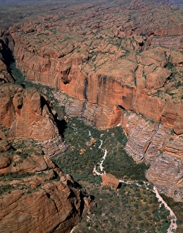
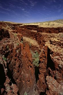
Western Australia, Karijini National Park, Pilbara region. Junction of Red, Joffre and Hancock Gorges. JPF28110JPF-13256 Western Australia, Karijini National Park, Pilbara region Junction of Red, Joffre and Hancock Gorges. Jean-Paul Ferrero Please note that prints are for personal display purposes only
Joffre Gorge Karijini National Park, Pilbara region, Western Australia JPF28667JPF-13225 Joffre Gorge Karijini National Park Pilbara region, Western Australia Jean-Paul Ferrero Please note that prints are for personal display purposes only and may not be reproduced in anyway